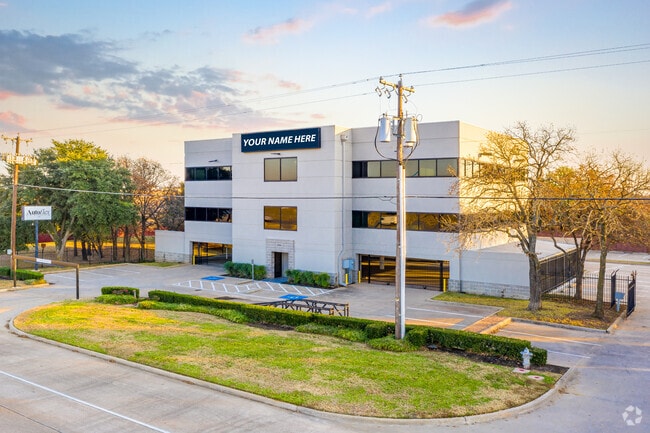
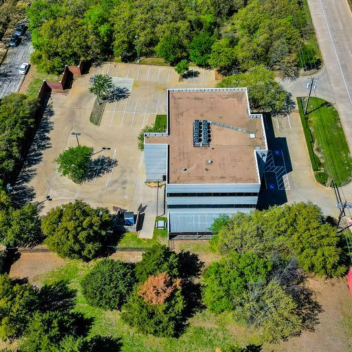
Property Record
2000 W Interstate 20, Arlington, TX 76017

Property Detail
2000 W Interstate 20
Dallas-Fort Worth-Arlington, TX
WIMBLEDON NORTH ADDITION BLOCK 8 LOT 5
03558096
TARRANT
Commercialnec
Texas
B and X Area of moderate flood hazard, usually the area between the limits of the 100-year and 500-year floods.
5
2024
1.08 AC
2025
Arlington/Mansfield
111530
Dallas/Ft Worth
13,368 SF
NEARBY LISTINGS FOR SALE OR LEASE
DEMOGRAPHICS near 2000 W Interstate 20
1 mile
3 mile
5 mile
2024 Total Population
7,081
116,034
324,990
2029 Population
7,333
121,254
340,400
Pop Growth 2024-2029
+ 3.56%
+ 4.50%
+ 4.74%
Average Age
42
39
38
2024 Total Households
2,958
42,156
113,513
HH Growth 2024-2029
+ 3.65%
+ 4.66%
+ 4.93%
Median Household Inc
$76,231
$83,237
$78,445
Avg Household Size
2.40
2.70
2.80
2024 Avg HH Vehicles
2.00
2.00
2.00
Median Home Value
$365,722
$315,602
$319,522
Median Year Built
1984
1985
1986
Nearby Places
Map Layers
Map Styles
 Street
 Aerial
Transit
 Traffic
 Biking
Places
Listings with unknown addresses are not visible on the map
- Restaurants
- Banks
- Shops
- Fitness
- Groceries
PUBLIC TRANSPORTATION
AIRPORT
Dallas-Fort Worth International
Drive
Walk
Distance
Dallas-Fort Worth International
31 min
21.9 mi
Dallas Love Field
Drive
Walk
Distance
Dallas Love Field
40 min
30.5 mi
SALE & LEASE HISTORY
LISTING DATE
SALE/LEASE

Jun 19, 2020
For Lease
Feb 10, 2021
For Sale
Feb 10, 2021
For Lease
Dec 10, 2020
For Sale
Dec 10, 2020
For Sale
Aug 14, 2024
For Sale
Apr 11, 2023
For Sale
Nearby Properties
Address
Land Use
TOTAL SIZE
Lot Size
Zoning
Address
Land Use
TOTAL SIZE
Lot Size
Zoning
1,342,617 SF
40.67 AC
Address
Land Use
TOTAL SIZE
Lot Size
Zoning
569,876 SF
47.80 AC
Address
Land Use
TOTAL SIZE
Lot Size
Zoning
537,189 SF
29.08 AC
Address
Land Use
TOTAL SIZE
Lot Size
Zoning
799,893 SF
19.43 AC
Address
Land Use
TOTAL SIZE
Lot Size
Zoning
377,463 SF
19.50 AC
Address
Land Use
TOTAL SIZE
Lot Size
Zoning
569,312 SF
71.52 AC
Address
Land Use
TOTAL SIZE
Lot Size
Zoning
462,396 SF
25.76 AC
Address
Land Use
TOTAL SIZE
Lot Size
Zoning
280,000 SF
10.85 AC
Address
Land Use
TOTAL SIZE
Lot Size
Zoning
296,092 SF
7.66 AC
Address
Land Use
TOTAL SIZE
Lot Size
Zoning
252,416 SF
15.86 AC
Address
Land Use
TOTAL SIZE
Lot Size
Zoning
858,995 SF
41.93 AC
Address
Land Use
TOTAL SIZE
Lot Size
Zoning
202,262 SF
12.59 AC
Address
Land Use
TOTAL SIZE
Lot Size
Zoning
28,825 SF
81.97 AC
Address
Land Use
TOTAL SIZE
Lot Size
Zoning
257,077 SF
14.49 AC
Address
Land Use
TOTAL SIZE
Lot Size
Zoning
268,340 SF
70 AC
Address
Land Use
TOTAL SIZE
Lot Size
Zoning
258,465 SF
8.99 AC
Address
Land Use
TOTAL SIZE
Lot Size
Zoning
425,000 SF
21.26 AC
Address
Land Use
TOTAL SIZE
Lot Size
Zoning
415,800 SF
20.97 AC
Address
Land Use
TOTAL SIZE
Lot Size
Zoning
218,110 SF
8.85 AC
Address
Land Use
TOTAL SIZE
Lot Size
Zoning
425,000 SF
21.82 AC
Address
Land Use
TOTAL SIZE
Lot Size
Zoning
226,623 SF
22.90 AC
Address
Land Use
TOTAL SIZE
Lot Size
Zoning
240,032 SF
11.27 AC
Address
Land Use
TOTAL SIZE
Lot Size
Zoning
281,009 SF
16.39 AC
Address
Land Use
TOTAL SIZE
Lot Size
Zoning
278,273 SF
9.09 AC
Address
Land Use
TOTAL SIZE
Lot Size
Zoning
202,827 SF
11.96 AC
Address
Land Use
TOTAL SIZE
Lot Size
Zoning
182,763 SF
10.54 AC
Address
Land Use
TOTAL SIZE
Lot Size
Zoning
208,010 SF
10 AC
Address
Land Use
TOTAL SIZE
Lot Size
Zoning
165,842 SF
9.48 AC
Address
Land Use
TOTAL SIZE
Lot Size
Zoning
246,060 SF
25.44 AC
Address
Land Use
TOTAL SIZE
Lot Size
Zoning
245,354 SF
30.82 AC
The World's #1 Commercial Real Estate Marketplace
Connect with us
© 2026 CoStar Group
The information above has been obtained from sources believed reliable. While we do not doubt its accuracy we have not verified it and make no guarantee, warranty or representation about it. It is your responsibility to independently confirm its accuracy and completeness. Any projections, opinions, assumptions, or estimates used are for example only and do not represent the current or future performance of the property. The value of this transaction to you depends on tax and other factors which should be evaluated by your tax, financial, and legal advisors. You and your advisors should conduct a careful, independent investigation of the property to determine to your satisfaction the suitability of the property for your needs.