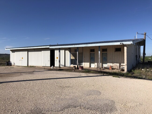
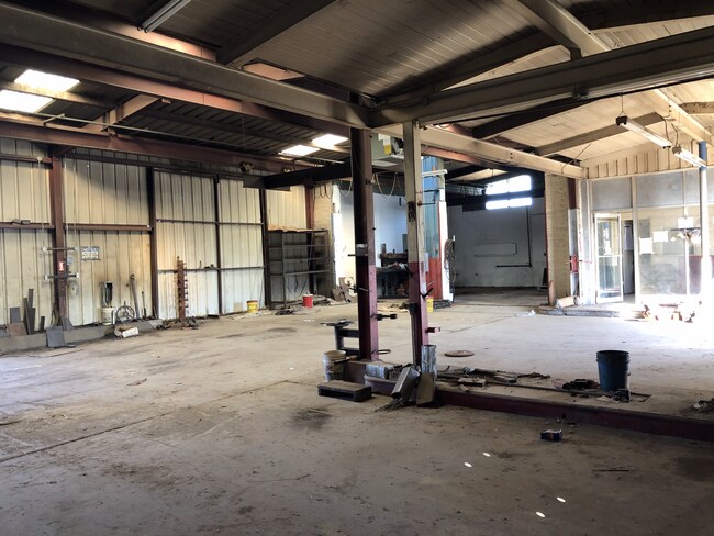
Property Record
2000 W Interstate 20, Big Spring, TX 79720

Property Detail
2000 W Interstate 20
297076
SC 26 BK 33 1N 023 BLK/TRACT 33 1N 1.76 ACRES ACQ 07212021
Commercialnec
HOWARD
B and X Area of moderate flood hazard, usually the area between the limits of the 100-year and 500-year floods.
Texas
2025
1.76 AC
2025
Texas West Area
950300
Other Market Areas
8,751 SF
Big Spring, TX
NEARBY LISTINGS FOR SALE OR LEASE
DEMOGRAPHICS near 2000 W Interstate 20
1 mile
3 mile
5 mile
2025 Total Population
537
13,633
24,985
2030 Population
540
13,417
24,631
Pop Growth 2025-2030
+ 0.56%
(1.58%)
(1.42%)
Average Age
41
39
39
2025 Total Households
203
5,061
8,876
HH Growth 2025-2030
+ 3.45%
(1.26%)
(1.76%)
Median Household Inc
$35,357
$61,124
$70,554
Avg Household Size
2.40
2.40
2.50
2025 Avg HH Vehicles
1.00
2.00
2.00
Median Home Value
$64,285
$96,248
$142,330
Median Year Built
1969
1962
1964
Nearby Places
Map Layers
Map Styles
 Street
 Aerial
Transit
 Traffic
 Biking
Places
Listings with unknown addresses are not visible on the map
- Restaurants
- Banks
- Shops
- Fitness
- Groceries
SALE & LEASE HISTORY
LISTING DATE
SALE/LEASE

Dec 18, 2019
For Sale
Nearby Properties
Address
Land Use
TOTAL SIZE
Lot Size
Zoning
Address
Land Use
TOTAL SIZE
Lot Size
Zoning
249,191 SF
13 AC
Address
Land Use
TOTAL SIZE
Lot Size
Zoning
99.22 AC
Address
Land Use
TOTAL SIZE
Lot Size
Zoning
225,060 SF
34 AC
Address
Land Use
TOTAL SIZE
Lot Size
Zoning
122,312 SF
8.41 AC
Address
Land Use
TOTAL SIZE
Lot Size
Zoning
119,700 SF
31 AC
Address
Land Use
TOTAL SIZE
Lot Size
Zoning
59.78 AC
Address
Land Use
TOTAL SIZE
Lot Size
Zoning
124,640 SF
14.74 AC
Address
Land Use
TOTAL SIZE
Lot Size
Zoning
134,210 SF
21.14 AC
Address
Land Use
TOTAL SIZE
Lot Size
Zoning
393,167 SF
5 AC
Address
Land Use
TOTAL SIZE
Lot Size
Zoning
89,840 SF
2.11 AC
Address
Land Use
TOTAL SIZE
Lot Size
Zoning
95,564 SF
57.84 AC
Address
Land Use
TOTAL SIZE
Lot Size
Zoning
161,078 SF
368 AC
Address
Land Use
TOTAL SIZE
Lot Size
Zoning
47,705 SF
1.86 AC
Address
Land Use
TOTAL SIZE
Lot Size
Zoning
63,804 SF
3.77 AC
Address
Land Use
TOTAL SIZE
Lot Size
Zoning
86,002 SF
4.13 AC
Address
Land Use
TOTAL SIZE
Lot Size
Zoning
95,454 SF
0.32 AC
Address
Land Use
TOTAL SIZE
Lot Size
Zoning
60,507 SF
125.89 AC
Address
Land Use
TOTAL SIZE
Lot Size
Zoning
75,540 SF
1.03 AC
Address
Land Use
TOTAL SIZE
Lot Size
Zoning
84,709 SF
0.96 AC
Address
Land Use
TOTAL SIZE
Lot Size
Zoning
393,341 SF
19.26 AC
Address
Land Use
TOTAL SIZE
Lot Size
Zoning
52,448 SF
1.92 AC
Address
Land Use
TOTAL SIZE
Lot Size
Zoning
11,687 SF
1.96 AC
Address
Land Use
TOTAL SIZE
Lot Size
Zoning
120,530 SF
5.41 AC
Address
Land Use
TOTAL SIZE
Lot Size
Zoning
190,928 SF
9.69 AC
Address
Land Use
TOTAL SIZE
Lot Size
Zoning
102,592 SF
1.57 AC
Address
Land Use
TOTAL SIZE
Lot Size
Zoning
2.78 AC
Address
Land Use
TOTAL SIZE
Lot Size
Zoning
155,178 SF
5.51 AC
Address
Land Use
TOTAL SIZE
Lot Size
Zoning
193 AC
Address
Land Use
TOTAL SIZE
Lot Size
Zoning
189,264 SF
1.57 AC
Address
Land Use
TOTAL SIZE
Lot Size
Zoning
52,000 SF
0.96 AC
The World's #1 Commercial Real Estate Marketplace
Connect with us
© 2026 CoStar Group
The information above has been obtained from sources believed reliable. While we do not doubt its accuracy we have not verified it and make no guarantee, warranty or representation about it. It is your responsibility to independently confirm its accuracy and completeness. Any projections, opinions, assumptions, or estimates used are for example only and do not represent the current or future performance of the property. The value of this transaction to you depends on tax and other factors which should be evaluated by your tax, financial, and legal advisors. You and your advisors should conduct a careful, independent investigation of the property to determine to your satisfaction the suitability of the property for your needs.