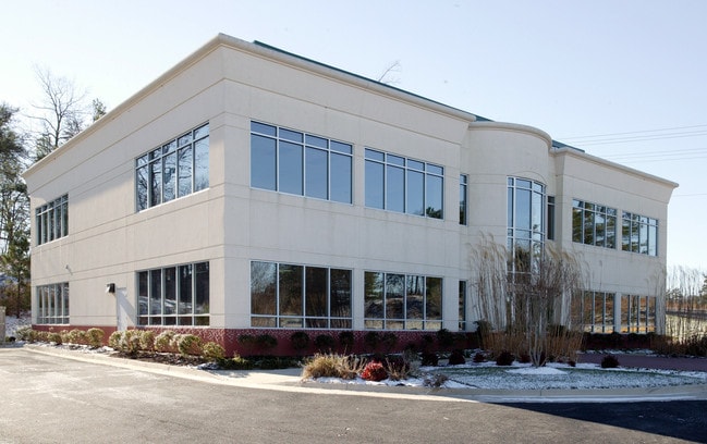
Property Record
2000 Ware Bottom Spring Rd, Chester, VA 23836


Current Lease Availabilities
Property Detail
2000 Ware Bottom Spring Rd
802-65-37-16-800-000
N/S WARE BOTTOM SPRNG RD PAR 2
Officebuilding
Chesterfield
C3 - COMMU
Virginia
B and X Area of moderate flood hazard, usually the area between the limits of the 100-year and 500-year floods.
2.23 AC
2026
Iron Bridge Corridor
2026
Richmond VA
100509
Richmond, VA
10,286 SF
NEARBY LISTINGS FOR SALE OR LEASE
DEMOGRAPHICS near 2000 Ware Bottom Spring Rd
1 mile
3 mile
5 mile
2025 Total Population
1,995
35,982
78,000
2030 Population
2,112
38,050
82,537
Pop Growth 2025-2030
+ 5.86%
+ 5.75%
+ 5.82%
Average Age
38
39
40
2025 Total Households
836
13,426
28,195
HH Growth 2025-2030
+ 6.10%
+ 5.88%
+ 6.11%
Median Household Inc
$80,152
$97,360
$95,304
Avg Household Size
2.30
2.60
2.60
2025 Avg HH Vehicles
2.00
2.00
2.00
Median Home Value
$279,203
$336,814
$333,861
Median Year Built
1987
1993
1992
Nearby Places
Map Layers
Map Styles
 Street
 Aerial
Layers
 Traffic
 Biking
Places
Listings with unknown addresses are not visible on the map
- Restaurants
- Banks
- Shops
- Fitness
- Groceries
PUBLIC TRANSPORTATION
COMMUTER RAIL
Drive
Walk
Distance
19 min
9.4 mi
AIRPORT
Richmond International
Drive
Walk
Distance
Richmond International
29 min
18.2 mi
Freight Ports
Virginia Port Authority - Richmond
Drive
Walk
Distance
Virginia Port Authority - Richmond
18 min
10.6 mi
Nearby Properties
Address
Land Use
TOTAL SIZE
Lot Size
Zoning
Address
Land Use
TOTAL SIZE
Lot Size
Zoning
640,864 SF
39.40 AC
I3 - HVY I
Address
Land Use
TOTAL SIZE
Lot Size
Zoning
289,964 SF
39.62 AC
R7 - SINGL
Address
Land Use
TOTAL SIZE
Lot Size
Zoning
98,841 SF
13.38 AC
C5 - GEN B
Address
Land Use
TOTAL SIZE
Lot Size
Zoning
1.60 AC
RMF - RES,
Address
Land Use
TOTAL SIZE
Lot Size
Zoning
138,854 SF
8.57 AC
I2 - GEN I
Address
Land Use
TOTAL SIZE
Lot Size
Zoning
100 SF
36.88 AC
RMF - RES,
Address
Land Use
TOTAL SIZE
Lot Size
Zoning
243,414 SF
27.31 AC
C2 - NBHD
Address
Land Use
TOTAL SIZE
Lot Size
Zoning
177,908 SF
13.59 AC
RMF - RES,
Address
Land Use
TOTAL SIZE
Lot Size
Zoning
233,054 SF
25.57 AC
RMF - RES,
Address
Land Use
TOTAL SIZE
Lot Size
Zoning
165,359 SF
17.72 AC
R15 - SING
Address
Land Use
TOTAL SIZE
Lot Size
Zoning
100 SF
25.80 AC
R7 - SINGL
Address
Land Use
TOTAL SIZE
Lot Size
Zoning
175,817 SF
11.82 AC
C3 - COMMU
Address
Land Use
TOTAL SIZE
Lot Size
Zoning
67,060 SF
4.93 AC
C5 - GEN B
Address
Land Use
TOTAL SIZE
Lot Size
Zoning
261,922 SF
19.85 AC
I1 - LT IN
Address
Land Use
TOTAL SIZE
Lot Size
Zoning
318,611 SF
24.17 AC
I3 - HVY I
Address
Land Use
TOTAL SIZE
Lot Size
Zoning
194,000 SF
175.55 AC
I1 - LT IN
Address
Land Use
TOTAL SIZE
Lot Size
Zoning
170,100 SF
17.77 AC
I3 - HVY I
Address
Land Use
TOTAL SIZE
Lot Size
Zoning
29,808 SF
5.63 AC
C3 - COMMU
Address
Land Use
TOTAL SIZE
Lot Size
Zoning
187,980 SF
15.31 AC
I1 - LT IN
Address
Land Use
TOTAL SIZE
Lot Size
Zoning
141,764 SF
20.08 AC
C3 - COMMU
Address
Land Use
TOTAL SIZE
Lot Size
Zoning
123,740 SF
29.94 AC
C3 - COMMU
Address
Land Use
TOTAL SIZE
Lot Size
Zoning
138,096 SF
16 AC
R7 - SINGL
Address
Land Use
TOTAL SIZE
Lot Size
Zoning
92,905 SF
24.72 AC
A - AGRICU
Address
Land Use
TOTAL SIZE
Lot Size
Zoning
12.69 AC
R7 - SINGL
Address
Land Use
TOTAL SIZE
Lot Size
Zoning
15,600 SF
3.97 AC
C3 - COMMU
Address
Land Use
TOTAL SIZE
Lot Size
Zoning
490,345 SF
101.57 AC
I2 - GEN I
Address
Land Use
TOTAL SIZE
Lot Size
Zoning
147,276 SF
27.04 AC
R7 - SINGL
Address
Land Use
TOTAL SIZE
Lot Size
Zoning
47.44 AC
MH1 - MOBI
Address
Land Use
TOTAL SIZE
Lot Size
Zoning
40,701 SF
17.96 AC
C5 - GEN B
Address
Land Use
TOTAL SIZE
Lot Size
Zoning
111,566 SF
19.01 AC
C3 - COMMU
The World's #1 Commercial Real Estate Marketplace
Connect with us
© 2026 CoStar Group
The information above has been obtained from sources believed reliable. While we do not doubt its accuracy we have not verified it and make no guarantee, warranty or representation about it. It is your responsibility to independently confirm its accuracy and completeness. Any projections, opinions, assumptions, or estimates used are for example only and do not represent the current or future performance of the property. The value of this transaction to you depends on tax and other factors which should be evaluated by your tax, financial, and legal advisors. You and your advisors should conduct a careful, independent investigation of the property to determine to your satisfaction the suitability of the property for your needs.