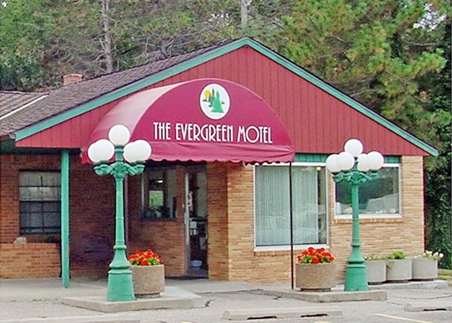
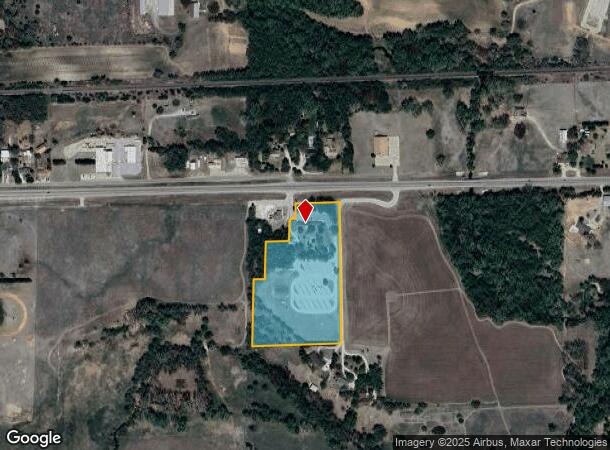
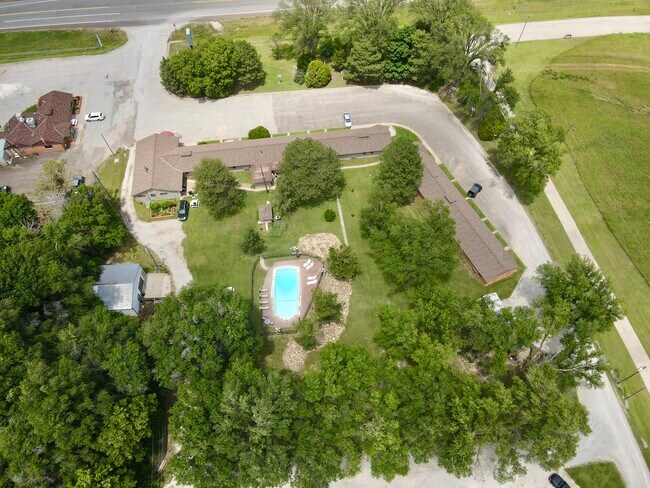
Property Record
20001 W Us Highway 54, Pratt, KS 67124
NEARBY LISTINGS FOR SALE OR LEASE
Property Detail
20001 W Us Highway 54
Other Market Areas
Subdivision 000
133-05-0-00-04-005.00-0
S05, T28, R13, ACRES 9.2, BEG 281.4E NW/C SW/4 NW/4 E 239.1 S 950 W 572.5 N 400 E 70 N 235 E 144.4 N 124 E 7 N 15 E 30 N 80 E
Motel
Pratt
2024
Kansas
2025
9.20 AC
968700
Kansas Area
6,114 SF
DEMOGRAPHICS near 20001 W Us Highway 54
1 Mile
3 Mile
5 Mile
2024 Total Population
199
6,975
7,265
2029 Population
194
6,889
7,176
Pop Growth 2024-2029
(2.51%)
(1.23%)
(1.23%)
Average Age
43
40
41
2024 Total Households
76
2,794
2,910
HH Growth 2024-2029
(2.63%)
(1.29%)
(1.27%)
Median Household Inc
$77,941
$56,383
$56,444
Avg Household Size
2.50
2.30
2.30
2024 Avg HH Vehicles
2.00
2.00
2.00
Median Home Value
$212,500
$115,300
$118,121
Median Year Built
1978
1954
1955
Nearby Places
Map Layers
Map Styles
 Street
 Aerial
- Restaurants
- Banks
- Shops
- Fitness
- Groceries
SALE & LEASE HISTORY
LISTING DATE
SALE/LEASE

Sep 13, 2019
For Sale
Nov 07, 2023
For Sale
Nov 02, 2021
For Sale
Nearby Properties
Address
Land Use
TOTAL SIZE
Lot Size
Zoning
Address
Land Use
TOTAL SIZE
Lot Size
Zoning
34,936 SF
9.50 AC
Address
Land Use
TOTAL SIZE
Lot Size
Zoning
129,534 SF
15 AC
Address
Land Use
TOTAL SIZE
Lot Size
Zoning
67,800 SF
38.60 AC
Address
Land Use
TOTAL SIZE
Lot Size
Zoning
31,087 SF
3.50 AC
Address
Land Use
TOTAL SIZE
Lot Size
Zoning
17,426 SF
0.79 AC
Address
Land Use
TOTAL SIZE
Lot Size
Zoning
37,939 SF
3.38 AC
Address
Land Use
TOTAL SIZE
Lot Size
Zoning
37,372 SF
2.10 AC
Address
Land Use
TOTAL SIZE
Lot Size
Zoning
14,200 SF
0.68 AC
Address
Land Use
TOTAL SIZE
Lot Size
Zoning
27,220 SF
6 AC
Address
Land Use
TOTAL SIZE
Lot Size
Zoning
21,912 SF
0.65 AC
Address
Land Use
TOTAL SIZE
Lot Size
Zoning
16,045 SF
2.90 AC
Address
Land Use
TOTAL SIZE
Lot Size
Zoning
38,480 SF
1.69 AC
Address
Land Use
TOTAL SIZE
Lot Size
Zoning
8,991 SF
4.90 AC
Address
Land Use
TOTAL SIZE
Lot Size
Zoning
10,392 SF
2.70 AC
Address
Land Use
TOTAL SIZE
Lot Size
Zoning
16,229 SF
16 AC
Address
Land Use
TOTAL SIZE
Lot Size
Zoning
9,724 SF
0.48 AC
Address
Land Use
TOTAL SIZE
Lot Size
Zoning
12,984 SF
0.81 AC
Address
Land Use
TOTAL SIZE
Lot Size
Zoning
6,496 SF
2.65 AC
Address
Land Use
TOTAL SIZE
Lot Size
Zoning
23,350 SF
0.57 AC
Address
Land Use
TOTAL SIZE
Lot Size
Zoning
5,672 SF
2.20 AC
Address
Land Use
TOTAL SIZE
Lot Size
Zoning
10,430 SF
0.41 AC
Address
Land Use
TOTAL SIZE
Lot Size
Zoning
7,182 SF
1.52 AC
Address
Land Use
TOTAL SIZE
Lot Size
Zoning
5,167 SF
0.33 AC
Address
Land Use
TOTAL SIZE
Lot Size
Zoning
5,976 SF
1.70 AC
Address
Land Use
TOTAL SIZE
Lot Size
Zoning
10,400 SF
0.65 AC
Address
Land Use
TOTAL SIZE
Lot Size
Zoning
4,617 SF
0.49 AC
Address
Land Use
TOTAL SIZE
Lot Size
Zoning
45.50 AC
Address
Land Use
TOTAL SIZE
Lot Size
Zoning
Address
Land Use
TOTAL SIZE
Lot Size
Zoning
3,300 SF
0.24 AC
Address
Land Use
TOTAL SIZE
Lot Size
Zoning
5,007 SF
0.49 AC
The World's #1 Commercial Real Estate Marketplace
Connect with us
© 2026 CoStar Group
The information above has been obtained from sources believed reliable. While we do not doubt its accuracy we have not verified it and make no guarantee, warranty or representation about it. It is your responsibility to independently confirm its accuracy and completeness. Any projections, opinions, assumptions, or estimates used are for example only and do not represent the current or future performance of the property. The value of this transaction to you depends on tax and other factors which should be evaluated by your tax, financial, and legal advisors. You and your advisors should conduct a careful, independent investigation of the property to determine to your satisfaction the suitability of the property for your needs.