Property Record
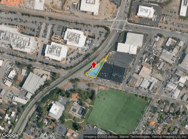
2001 Spring St, Redwood City, CA 94063
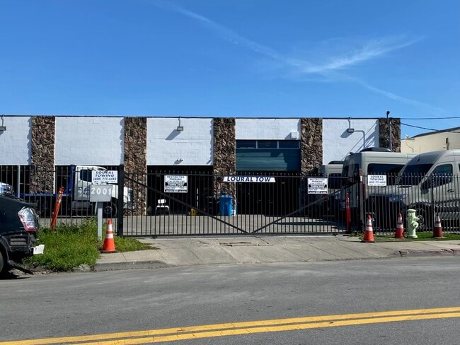
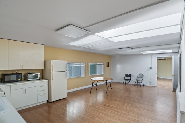

This Property Is For Sale
NEARBY LISTINGS FOR SALE OR LEASE
Property Detail
2001 Spring St
San Francisco-Redwood City-South San Francisco, CA
Dumbarton Acres
054-065-010
ON NELY COR OF SPRING ST & WOODSIDE EXPRESSWAY BEING PTN OF LOT A DUMBARTON ACRES RSM 16/8
Miscellaneous
San Mateo
X
California
06081C0302F
a
2024
0.30 AC
2025
Redwood City
610201
San Francisco
5,124 SF
DEMOGRAPHICS near 2001 Spring St
1 Mile
3 Mile
5 Mile
2024 Total Population
29,616
117,906
255,162
2029 Population
28,553
112,965
244,179
Pop Growth 2024-2029
(3.59%)
(4.19%)
(4.30%)
Average Age
37
40
40
2024 Total Households
9,906
41,875
90,183
HH Growth 2024-2029
(3.21%)
(4.21%)
(4.39%)
Median Household Inc
$92,128
$140,863
$151,730
Avg Household Size
2.80
2.70
2.60
2024 Avg HH Vehicles
2.00
2.00
2.00
Median Home Value
$1,064,366
$1,128,914
$1,131,286
Median Year Built
1975
1962
1966
Nearby Places
- Restaurants
- Banks
- Shops
- Fitness
- Groceries
PUBLIC TRANSPORTATION
COMMUTER RAIL
Redwood City (Caltrain - Caltrain (Caltrain))
DRIVE
WALK
Distance
Redwood City (Caltrain - Caltrain (Caltrain))
4 min
16 min
0.8 mi
Menlo Park (Caltrain - Caltrain (Caltrain))
DRIVE
WALK
Distance
Menlo Park (Caltrain - Caltrain (Caltrain))
11 min
3.8 mi
AIRPORT
San Francisco International
DRIVE
WALK
Distance
San Francisco International
17 min
15.1 mi
Norman Y Mineta San Jose International
DRIVE
WALK
Distance
Norman Y Mineta San Jose International
21 min
19.0 mi
Metro Oakland International
DRIVE
WALK
Distance
Metro Oakland International
34 min
30.6 mi
Freight Ports
Port of Redwood City
DRIVE
WALK
Distance
Port of Redwood City
1 min
1.7 mi
Nearby Properties
Address
Land Use
TOTAL SIZE
Lot Size
Zoning
Address
Land Use
TOTAL SIZE
Lot Size
Zoning
719,052 SF
56.03 AC
Address
Land Use
TOTAL SIZE
Lot Size
Zoning
Address
Land Use
TOTAL SIZE
Lot Size
Zoning
520,988 SF
8.88 AC
Address
Land Use
TOTAL SIZE
Lot Size
Zoning
373,238 SF
7.94 AC
Address
Land Use
TOTAL SIZE
Lot Size
Zoning
8.31 AC
EA00CA
Address
Land Use
TOTAL SIZE
Lot Size
Zoning
491,030 SF
2.74 AC
Address
Land Use
TOTAL SIZE
Lot Size
Zoning
528,437 SF
9.69 AC
Address
Land Use
TOTAL SIZE
Lot Size
Zoning
330,071 SF
1.64 AC
Address
Land Use
TOTAL SIZE
Lot Size
Zoning
210,000 SF
10.79 AC
Address
Land Use
TOTAL SIZE
Lot Size
Zoning
283,015 SF
8.77 AC
Address
Land Use
TOTAL SIZE
Lot Size
Zoning
Address
Land Use
TOTAL SIZE
Lot Size
Zoning
Address
Land Use
TOTAL SIZE
Lot Size
Zoning
378,534 SF
2.24 AC
Address
Land Use
TOTAL SIZE
Lot Size
Zoning
283,015 SF
7.66 AC
Address
Land Use
TOTAL SIZE
Lot Size
Zoning
247,567 SF
3.52 AC
Address
Land Use
TOTAL SIZE
Lot Size
Zoning
368,000 SF
11.32 AC
Address
Land Use
TOTAL SIZE
Lot Size
Zoning
40,000 SF
1.60 AC
Address
Land Use
TOTAL SIZE
Lot Size
Zoning
61.20 AC
R10000
Address
Land Use
TOTAL SIZE
Lot Size
Zoning
395,625 SF
5.08 AC
Address
Land Use
TOTAL SIZE
Lot Size
Zoning
458,111 SF
2.26 AC
Address
Land Use
TOTAL SIZE
Lot Size
Zoning
2.69 AC
ML001R
Address
Land Use
TOTAL SIZE
Lot Size
Zoning
Address
Land Use
TOTAL SIZE
Lot Size
Zoning
16.43 AC
Address
Land Use
TOTAL SIZE
Lot Size
Zoning
366,384 SF
3.63 AC
Address
Land Use
TOTAL SIZE
Lot Size
Zoning
249,198 SF
1.14 AC
Address
Land Use
TOTAL SIZE
Lot Size
Zoning
171,563 SF
3.57 AC
Address
Land Use
TOTAL SIZE
Lot Size
Zoning
2,023 SF
1.31 AC
Address
Land Use
TOTAL SIZE
Lot Size
Zoning
262,189 SF
1.16 AC
Address
Land Use
TOTAL SIZE
Lot Size
Zoning
2,024 SF
1.38 AC
Address
Land Use
TOTAL SIZE
Lot Size
Zoning
68,488 SF
1.38 AC
M20000
The World's #1 Commercial Real Estate Marketplace
Connect with us
© 2025 CoStar Group
The information above has been obtained from sources believed reliable. While we do not doubt its accuracy we have not verified it and make no guarantee, warranty or representation about it. It is your responsibility to independently confirm its accuracy and completeness. Any projections, opinions, assumptions, or estimates used are for example only and do not represent the current or future performance of the property. The value of this transaction to you depends on tax and other factors which should be evaluated by your tax, financial, and legal advisors. You and your advisors should conduct a careful, independent investigation of the property to determine to your satisfaction the suitability of the property for your needs.