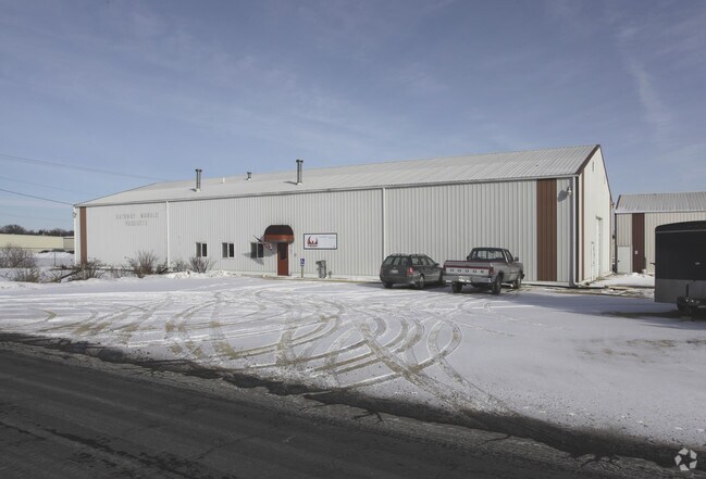
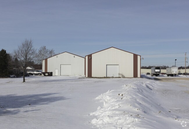
Property Record
2001 9Th St, Fulton, IL 61252
NEARBY LISTINGS FOR SALE OR LEASE
Property Detail
2001 9Th St
Sterling, IL
FULTON INDUSTRIAL DEVELOPMENT #2 W 15' LOT 3
0133201021
Whiteside
Industrialgeneral
Illinois
X
3
19045C0506F
0.42 AC
2024
Illinois North Area
2024
Other Market Areas
000400
DEMOGRAPHICS near 2001 9Th St
1 Mile
3 Mile
5 Mile
2024 Total Population
3,072
23,213
29,993
2029 Population
3,010
23,293
30,010
Pop Growth 2024-2029
(2.02%)
+ 0.34%
+ 0.06%
Average Age
42
42
42
2024 Total Households
1,361
9,974
12,840
HH Growth 2024-2029
(2.06%)
+ 0.34%
+ 0.05%
Median Household Inc
$48,940
$48,997
$50,808
Avg Household Size
2.20
2.20
2.20
2024 Avg HH Vehicles
2.00
2.00
2.00
Median Home Value
$103,870
$112,917
$118,627
Median Year Built
1956
1951
1953
Nearby Places
Map Layers
Map Styles
 Street
 Aerial
- Restaurants
- Banks
- Shops
- Fitness
- Groceries
PUBLIC TRANSPORTATION
AIRPORT
Quad Cities International
DRIVE
WALK
Distance
Quad Cities International
63 min
39.8 mi
Nearby Properties
Address
Land Use
TOTAL SIZE
Lot Size
Zoning
Address
Land Use
TOTAL SIZE
Lot Size
Zoning
165,649 SF
8.31 AC
Address
Land Use
TOTAL SIZE
Lot Size
Zoning
276,147 SF
15.22 AC
Address
Land Use
TOTAL SIZE
Lot Size
Zoning
61,488 SF
33.25 AC
Address
Land Use
TOTAL SIZE
Lot Size
Zoning
4.80 AC
Address
Land Use
TOTAL SIZE
Lot Size
Zoning
76,937 SF
8.26 AC
Address
Land Use
TOTAL SIZE
Lot Size
Zoning
36.01 AC
Address
Land Use
TOTAL SIZE
Lot Size
Zoning
112,935 SF
4.40 AC
Address
Land Use
TOTAL SIZE
Lot Size
Zoning
38,760 SF
14.91 AC
Address
Land Use
TOTAL SIZE
Lot Size
Zoning
85,930 SF
12 AC
Address
Land Use
TOTAL SIZE
Lot Size
Zoning
67,153 SF
3.16 AC
Address
Land Use
TOTAL SIZE
Lot Size
Zoning
960 SF
21.56 AC
Address
Land Use
TOTAL SIZE
Lot Size
Zoning
71,060 SF
7.36 AC
Address
Land Use
TOTAL SIZE
Lot Size
Zoning
29,485 SF
5.17 AC
Address
Land Use
TOTAL SIZE
Lot Size
Zoning
18,078 SF
5.89 AC
Address
Land Use
TOTAL SIZE
Lot Size
Zoning
48,728 SF
0.48 AC
Address
Land Use
TOTAL SIZE
Lot Size
Zoning
38,240 SF
19.75 AC
Address
Land Use
TOTAL SIZE
Lot Size
Zoning
45,410 SF
1.80 AC
Address
Land Use
TOTAL SIZE
Lot Size
Zoning
35,806 SF
4.13 AC
Address
Land Use
TOTAL SIZE
Lot Size
Zoning
55,006 SF
0.69 AC
Address
Land Use
TOTAL SIZE
Lot Size
Zoning
153,504 SF
148.23 AC
Address
Land Use
TOTAL SIZE
Lot Size
Zoning
18,360 SF
2.25 AC
Address
Land Use
TOTAL SIZE
Lot Size
Zoning
6,400 SF
5.85 AC
Address
Land Use
TOTAL SIZE
Lot Size
Zoning
25,967 SF
3.88 AC
Address
Land Use
TOTAL SIZE
Lot Size
Zoning
21,326 SF
2.21 AC
Address
Land Use
TOTAL SIZE
Lot Size
Zoning
2,464 SF
5.03 AC
Address
Land Use
TOTAL SIZE
Lot Size
Zoning
11,772 SF
Address
Land Use
TOTAL SIZE
Lot Size
Zoning
40,934 SF
5.28 AC
Address
Land Use
TOTAL SIZE
Lot Size
Zoning
18,060 SF
2.38 AC
Address
Land Use
TOTAL SIZE
Lot Size
Zoning
24,377 SF
3.75 AC
Address
Land Use
TOTAL SIZE
Lot Size
Zoning
840 SF
9.74 AC
The World's #1 Commercial Real Estate Marketplace
Connect with us
© 2026 CoStar Group
The information above has been obtained from sources believed reliable. While we do not doubt its accuracy we have not verified it and make no guarantee, warranty or representation about it. It is your responsibility to independently confirm its accuracy and completeness. Any projections, opinions, assumptions, or estimates used are for example only and do not represent the current or future performance of the property. The value of this transaction to you depends on tax and other factors which should be evaluated by your tax, financial, and legal advisors. You and your advisors should conduct a careful, independent investigation of the property to determine to your satisfaction the suitability of the property for your needs.