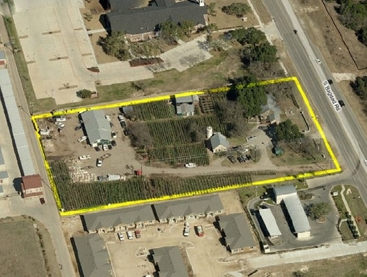
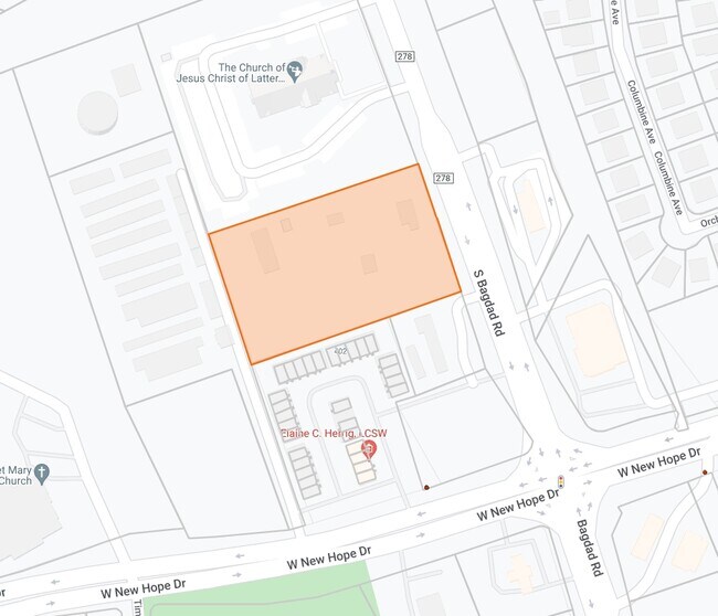
Property Record
2001 Bagdad Rd, Cedar Park, TX 78613

Save to a Folder
{{folder.Name}}
{{folder.ListingIds.length}} Properties
{{folder.ListingIds.length}} Property
Create a New Folder
Property Detail
2001 Bagdad Rd
Austin-Round Rock-San Marcos, TX
S6299 - ACORN ACRES, LOT 1, ACRES 3.36
R362149
Williamson
Commercialnec
Texas
B and X Area of moderate flood hazard, usually the area between the limits of the 100-year and 500-year floods.
1
2024
3.36 AC
2025
Cedar Park
020323
Austin
3,189 SF
NEARBY LISTINGS FOR SALE OR LEASE
DEMOGRAPHICS near 2001 Bagdad Rd
1 mile
3 mile
5 mile
2025 Total Population
13,834
86,194
182,465
2030 Population
15,548
97,342
206,468
Pop Growth 2025-2030
+ 12.39%
+ 12.93%
+ 13.15%
Average Age
37
37
37
2025 Total Households
5,021
30,349
65,929
HH Growth 2025-2030
+ 12.97%
+ 13.48%
+ 13.74%
Median Household Inc
$90,910
$122,630
$128,269
Avg Household Size
2.70
2.80
2.70
2025 Avg HH Vehicles
2.00
2.00
2.00
Median Home Value
$394,565
$474,136
$508,155
Median Year Built
1999
2005
2008
Nearby Places
Map Layers
Map Styles
 Street
 Aerial
Layers
 Traffic
 Biking
Places
Listings with unknown addresses are not visible on the map
- Restaurants
- Banks
- Shops
- Fitness
- Groceries
PUBLIC TRANSPORTATION
AIRPORT
Austin-Bergstrom International
Drive
Walk
Distance
Austin-Bergstrom International
48 min
34.2 mi
Freight Ports
Calhoun Port
Drive
Walk
Distance
Calhoun Port
213 min
177.7 mi
Nearby Properties
Address
Land Use
TOTAL SIZE
Lot Size
Zoning
Address
Land Use
TOTAL SIZE
Lot Size
Zoning
338,919 SF
42.88 AC
Address
Land Use
TOTAL SIZE
Lot Size
Zoning
313,727 SF
6.64 AC
Address
Land Use
TOTAL SIZE
Lot Size
Zoning
324,508 SF
24.08 AC
Address
Land Use
TOTAL SIZE
Lot Size
Zoning
181,000 SF
30.14 AC
Address
Land Use
TOTAL SIZE
Lot Size
Zoning
325,045 SF
22.75 AC
Address
Land Use
TOTAL SIZE
Lot Size
Zoning
335,765 SF
4.10 AC
Address
Land Use
TOTAL SIZE
Lot Size
Zoning
223,681 SF
7.78 AC
Address
Land Use
TOTAL SIZE
Lot Size
Zoning
250,556 SF
17.51 AC
Address
Land Use
TOTAL SIZE
Lot Size
Zoning
205,563 SF
18.24 AC
4-GR
Address
Land Use
TOTAL SIZE
Lot Size
Zoning
180,799 SF
22.90 AC
Address
Land Use
TOTAL SIZE
Lot Size
Zoning
117,076 SF
15.51 AC
Address
Land Use
TOTAL SIZE
Lot Size
Zoning
195,426 SF
12.11 AC
Address
Land Use
TOTAL SIZE
Lot Size
Zoning
316,408 SF
15 AC
Address
Land Use
TOTAL SIZE
Lot Size
Zoning
149,429 SF
16.98 AC
Address
Land Use
TOTAL SIZE
Lot Size
Zoning
94,861 SF
12.72 AC
Address
Land Use
TOTAL SIZE
Lot Size
Zoning
151,181 SF
6 AC
Address
Land Use
TOTAL SIZE
Lot Size
Zoning
89,872 SF
45.29 AC
Address
Land Use
TOTAL SIZE
Lot Size
Zoning
240,800 SF
17.16 AC
Address
Land Use
TOTAL SIZE
Lot Size
Zoning
264,140 SF
21.37 AC
Address
Land Use
TOTAL SIZE
Lot Size
Zoning
173,199 SF
7.66 AC
Address
Land Use
TOTAL SIZE
Lot Size
Zoning
47,009 SF
1.59 AC
Address
Land Use
TOTAL SIZE
Lot Size
Zoning
86,764 SF
Address
Land Use
TOTAL SIZE
Lot Size
Zoning
251,691 SF
14.73 AC
Address
Land Use
TOTAL SIZE
Lot Size
Zoning
72,489 SF
8.99 AC
Address
Land Use
TOTAL SIZE
Lot Size
Zoning
166,265 SF
15.29 AC
3-PD
Address
Land Use
TOTAL SIZE
Lot Size
Zoning
41,891 SF
10.42 AC
Address
Land Use
TOTAL SIZE
Lot Size
Zoning
123,858 SF
6.06 AC
Address
Land Use
TOTAL SIZE
Lot Size
Zoning
185,652 SF
10 AC
Address
Land Use
TOTAL SIZE
Lot Size
Zoning
299,242 SF
29.11 AC
Address
Land Use
TOTAL SIZE
Lot Size
Zoning
75,796 SF
5.62 AC
The World's #1 Commercial Real Estate Marketplace
Connect with us
© 2026 CoStar Group
The information above has been obtained from sources believed reliable. While we do not doubt its accuracy we have not verified it and make no guarantee, warranty or representation about it. It is your responsibility to independently confirm its accuracy and completeness. Any projections, opinions, assumptions, or estimates used are for example only and do not represent the current or future performance of the property. The value of this transaction to you depends on tax and other factors which should be evaluated by your tax, financial, and legal advisors. You and your advisors should conduct a careful, independent investigation of the property to determine to your satisfaction the suitability of the property for your needs.