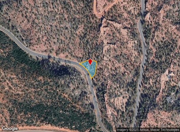
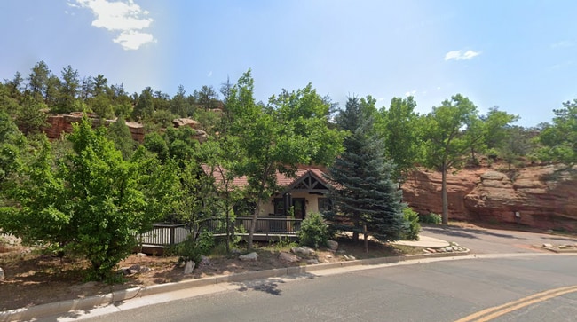
Property Record
2001 Black Canyon Rd, Colorado Springs, CO 80904

Current Lease Availabilities
NEARBY LISTINGS FOR SALE OR LEASE
Property Detail
2001 Black Canyon Rd
74042-00-013
Monument Add
Officebuilding
TRACT OF LAND IN SE4NW4 OF SEC 04-14-67 DESC AS FOLS: BEG AT PT WHICH BEARS N 35<4837 E 577.28 FT FROM SW COR OF SE4NW4 OF SD SEC 4, TH NWLY ALG ARC OF NON-TANG CUR TO L WITH A RAD OF 239.21 FT A C/A OF 48<0116 AN ARC DIST OF 200.49 FT, N 67<0259 E 1
X
El Paso
08041C0707G
Colorado
2024
0.39 AC
2025
Northwest
006701
Colorado Springs
880 SF
Colorado Springs, CO
DEMOGRAPHICS near 2001 Black Canyon Rd
1 Mile
3 Mile
5 Mile
2024 Total Population
3,944
25,066
81,878
2029 Population
4,170
26,638
86,846
Pop Growth 2024-2029
+ 5.73%
+ 6.27%
+ 6.07%
Average Age
47
46
43
2024 Total Households
1,939
12,032
37,830
HH Growth 2024-2029
+ 6.29%
+ 6.88%
+ 6.69%
Median Household Inc
$91,439
$79,965
$75,678
Avg Household Size
2.00
2.00
2.00
2024 Avg HH Vehicles
2.00
2.00
2.00
Median Home Value
$652,830
$566,458
$537,588
Median Year Built
1965
1976
1976
Nearby Places
- Restaurants
- Banks
- Shops
- Fitness
- Groceries
PUBLIC TRANSPORTATION
AIRPORT
City of Colorado Springs Municipal
DRIVE
WALK
Distance
City of Colorado Springs Municipal
28 min
15.5 mi
Freight Ports
Tulsa Port Of Catoosa
DRIVE
WALK
Distance
Tulsa Port Of Catoosa
751 min
699.5 mi
Nearby Properties
Address
Land Use
TOTAL SIZE
Lot Size
Zoning
Address
Land Use
TOTAL SIZE
Lot Size
Zoning
107,247 SF
56.98 AC
R-E PF
Address
Land Use
TOTAL SIZE
Lot Size
Zoning
139,621 SF
403.34 AC
A R-E HS
Address
Land Use
TOTAL SIZE
Lot Size
Zoning
2,422 SF
616.19 AC
PK MX-I PD
Address
Land Use
TOTAL SIZE
Lot Size
Zoning
75,349 SF
27.75 AC
EPC
Address
Land Use
TOTAL SIZE
Lot Size
Zoning
45,268 SF
8.37 AC
PDZ UV
Address
Land Use
TOTAL SIZE
Lot Size
Zoning
37,196 SF
3 AC
PDZ
Address
Land Use
TOTAL SIZE
Lot Size
Zoning
99,085 SF
6.85 AC
R-1 6
Address
Land Use
TOTAL SIZE
Lot Size
Zoning
282,722 SF
11.15 AC
PDZ HS SS
Address
Land Use
TOTAL SIZE
Lot Size
Zoning
296,778 SF
14.67 AC
MX-M HS CU
Address
Land Use
TOTAL SIZE
Lot Size
Zoning
184,424 SF
15.83 AC
BP
Address
Land Use
TOTAL SIZE
Lot Size
Zoning
34,126 SF
1.37 AC
Address
Land Use
TOTAL SIZE
Lot Size
Zoning
129,525 SF
9 AC
PDZ SS
Address
Land Use
TOTAL SIZE
Lot Size
Zoning
267,790 SF
15.13 AC
PDZ HS
Address
Land Use
TOTAL SIZE
Lot Size
Zoning
115,608 SF
9.45 AC
MX-M
Address
Land Use
TOTAL SIZE
Lot Size
Zoning
157,471 SF
0.02 AC
PUD,HS
Address
Land Use
TOTAL SIZE
Lot Size
Zoning
17,764 SF
1.63 AC
PDZ
Address
Land Use
TOTAL SIZE
Lot Size
Zoning
20,147 SF
38.98 AC
PK HS
Address
Land Use
TOTAL SIZE
Lot Size
Zoning
127.25 AC
PK HS
Address
Land Use
TOTAL SIZE
Lot Size
Zoning
31,314 SF
1.55 AC
MX-M/CR
Address
Land Use
TOTAL SIZE
Lot Size
Zoning
34,296 SF
0.85 AC
Address
Land Use
TOTAL SIZE
Lot Size
Zoning
3,058 SF
28.22 AC
HLDR
Address
Land Use
TOTAL SIZE
Lot Size
Zoning
6,658 SF
189.56 AC
R-E PK HS
Address
Land Use
TOTAL SIZE
Lot Size
Zoning
14,263 SF
0.98 AC
R-2 R-5
Address
Land Use
TOTAL SIZE
Lot Size
Zoning
129,554 SF
10 AC
BP
Address
Land Use
TOTAL SIZE
Lot Size
Zoning
80 AC
PK HS SS
Address
Land Use
TOTAL SIZE
Lot Size
Zoning
1,188 SF
27.20 AC
R-E
Address
Land Use
TOTAL SIZE
Lot Size
Zoning
464,447 SF
17.53 AC
PDZ
Address
Land Use
TOTAL SIZE
Lot Size
Zoning
33,548 SF
3.80 AC
R-E
Address
Land Use
TOTAL SIZE
Lot Size
Zoning
31,110 SF
9.38 AC
R-1 6
Address
Land Use
TOTAL SIZE
Lot Size
Zoning
4,062 SF
355.88 AC
PK HS
The World's #1 Commercial Real Estate Marketplace
Connect with us
© 2025 CoStar Group
The information above has been obtained from sources believed reliable. While we do not doubt its accuracy we have not verified it and make no guarantee, warranty or representation about it. It is your responsibility to independently confirm its accuracy and completeness. Any projections, opinions, assumptions, or estimates used are for example only and do not represent the current or future performance of the property. The value of this transaction to you depends on tax and other factors which should be evaluated by your tax, financial, and legal advisors. You and your advisors should conduct a careful, independent investigation of the property to determine to your satisfaction the suitability of the property for your needs.