Property Record
2001 Courthouse Rd, Stafford, VA 22554
NEARBY LISTINGS FOR SALE OR LEASE
-
-
View all Stafford listings for sale on LoopNet.com
Property Detail
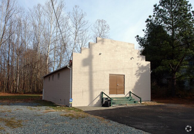
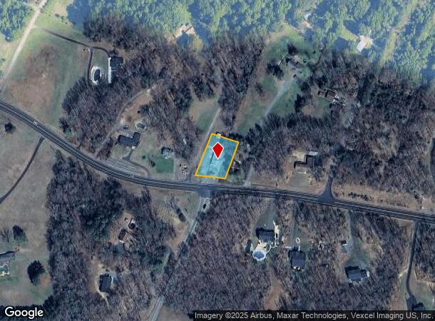
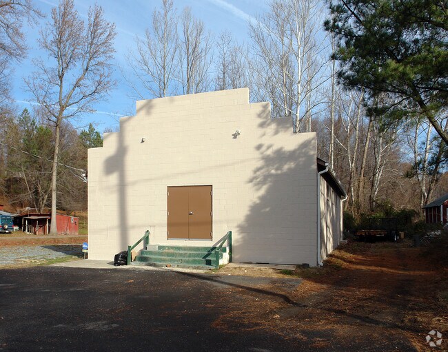
2001 Courthouse Rd
Washington-Arlington-Alexandria, DC-VA-MD-WV
Brooke
39-146C
BROOKE STORE LOT (14,480 SQFT)
Charitableorganization
Stafford
X
Virginia
51179C0144F
14
0
0.49 AC
2025
Stafford County
010105
Washington, DC
2,112 SF
DEMOGRAPHICS near 2001 Courthouse Rd
1 Mile
3 Mile
5 Mile
2024 Total Population
948
15,746
45,991
2029 Population
1,071
17,551
51,158
Pop Growth 2024-2029
+ 12.97%
+ 11.46%
+ 11.23%
Average Age
40
37
36
2024 Total Households
325
4,810
14,368
HH Growth 2024-2029
+ 12.92%
+ 11.98%
+ 11.45%
Median Household Inc
$130,555
$121,480
$124,790
Avg Household Size
2.80
3.00
3.10
2024 Avg HH Vehicles
3.00
3.00
2.00
Median Home Value
$524,038
$430,520
$431,187
Median Year Built
1999
1996
1996
Nearby Places
Map Layers
Map Styles
 Street
 Aerial
- Restaurants
- Banks
- Shops
- Fitness
- Groceries
PUBLIC TRANSPORTATION
COMMUTER RAIL
Brooke (Fredericksburg Line - Virginia Railway Express)
DRIVE
WALK
Distance
Brooke (Fredericksburg Line - Virginia Railway Express)
4 min
1.2 mi
Leeland Road (Fredericksburg Line - Virginia Railway Express)
DRIVE
WALK
Distance
Leeland Road (Fredericksburg Line - Virginia Railway Express)
13 min
6.6 mi
AIRPORT
Ronald Reagan Washington Ntl
DRIVE
WALK
Distance
Ronald Reagan Washington Ntl
61 min
43.2 mi
Nearby Properties
Address
Land Use
TOTAL SIZE
Lot Size
Zoning
Address
Land Use
TOTAL SIZE
Lot Size
Zoning
261,502 SF
33.80 AC
B2
Address
Land Use
TOTAL SIZE
Lot Size
Zoning
536,192 SF
72.22 AC
B2
Address
Land Use
TOTAL SIZE
Lot Size
Zoning
4,951 SF
36.12 AC
R2
Address
Land Use
TOTAL SIZE
Lot Size
Zoning
353,124 SF
17.78 AC
UD
Address
Land Use
TOTAL SIZE
Lot Size
Zoning
303,859 SF
77.36 AC
B3
Address
Land Use
TOTAL SIZE
Lot Size
Zoning
249,752 SF
50 AC
A1
Address
Land Use
TOTAL SIZE
Lot Size
Zoning
122,875 SF
11.61 AC
B2
Address
Land Use
TOTAL SIZE
Lot Size
Zoning
297,647 SF
54.88 AC
M1
Address
Land Use
TOTAL SIZE
Lot Size
Zoning
174,539 SF
11.37 AC
B3
Address
Land Use
TOTAL SIZE
Lot Size
Zoning
125,322 SF
18.81 AC
B2
Address
Land Use
TOTAL SIZE
Lot Size
Zoning
79,114 SF
15.87 AC
R1
Address
Land Use
TOTAL SIZE
Lot Size
Zoning
85,700 SF
9.55 AC
R1
Address
Land Use
TOTAL SIZE
Lot Size
Zoning
94,014 SF
4.43 AC
B2
Address
Land Use
TOTAL SIZE
Lot Size
Zoning
16,820 SF
37.60 AC
B3
Address
Land Use
TOTAL SIZE
Lot Size
Zoning
27,217 SF
8.16 AC
A1
Address
Land Use
TOTAL SIZE
Lot Size
Zoning
34,348 SF
2.10 AC
B2
Address
Land Use
TOTAL SIZE
Lot Size
Zoning
21,312 SF
4.54 AC
B2
Address
Land Use
TOTAL SIZE
Lot Size
Zoning
31.71 AC
M1
Address
Land Use
TOTAL SIZE
Lot Size
Zoning
39,353 SF
3.32 AC
B3
Address
Land Use
TOTAL SIZE
Lot Size
Zoning
16,702 SF
5.67 AC
R1
Address
Land Use
TOTAL SIZE
Lot Size
Zoning
42,625 SF
4.06 AC
B3
Address
Land Use
TOTAL SIZE
Lot Size
Zoning
37,250 SF
2.13 AC
R1
Address
Land Use
TOTAL SIZE
Lot Size
Zoning
25,200 SF
1.81 AC
B2
Address
Land Use
TOTAL SIZE
Lot Size
Zoning
25,484 SF
6.20 AC
R1
Address
Land Use
TOTAL SIZE
Lot Size
Zoning
241.45 AC
A1
Address
Land Use
TOTAL SIZE
Lot Size
Zoning
11,518 SF
3 AC
B2
Address
Land Use
TOTAL SIZE
Lot Size
Zoning
48,310 SF
4.89 AC
A1
Address
Land Use
TOTAL SIZE
Lot Size
Zoning
The World's #1 Commercial Real Estate Marketplace
Connect with us
© 2025 CoStar Group
The information above has been obtained from sources believed reliable. While we do not doubt its accuracy we have not verified it and make no guarantee, warranty or representation about it. It is your responsibility to independently confirm its accuracy and completeness. Any projections, opinions, assumptions, or estimates used are for example only and do not represent the current or future performance of the property. The value of this transaction to you depends on tax and other factors which should be evaluated by your tax, financial, and legal advisors. You and your advisors should conduct a careful, independent investigation of the property to determine to your satisfaction the suitability of the property for your needs.