Property Record
2001 E 11 Mile Rd, Warren, MI 48092

Save to a Folder
{{folder.Name}}
{{folder.ListingIds.length}} Properties
{{folder.ListingIds.length}} Property
Create a New Folder
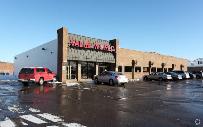
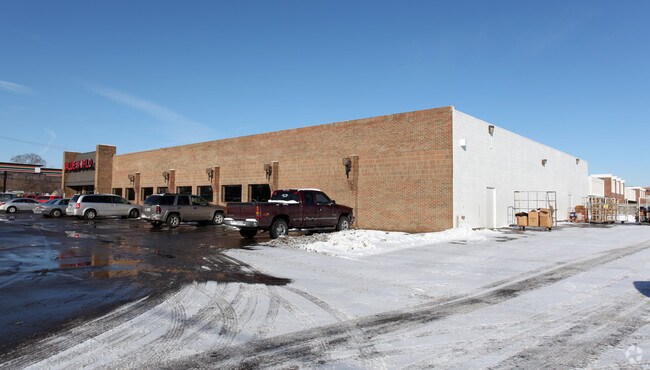
Property Detail
2001 E 11 Mile Rd
12-13-18-351-009
T1N,R12E,SEC 18,COMM AT SW CORSEC 18;TH NORTH 302.07 FT ALG THE C/L OF DEQUINDRE RD; TH S88*25'45"E 210.10 FT;TO POB; TH
Storebuilding
MACOMB
C-2
Michigan
B and X Area of moderate flood hazard, usually the area between the limits of the 100-year and 500-year floods.
1.15 AC
2025
Macomb West
2026
Detroit
262300
Detroit-Warren-Dearborn, MI
15,000 SF
NEARBY LISTINGS FOR SALE OR LEASE
DEMOGRAPHICS near 2001 E 11 Mile Rd
1 mile
3 mile
5 mile
2025 Total Population
14,158
115,592
334,614
2030 Population
14,276
117,316
339,602
Pop Growth 2025-2030
+ 0.83%
+ 1.49%
+ 1.49%
Average Age
42
41
41
2025 Total Households
6,270
50,881
144,082
HH Growth 2025-2030
+ 0.85%
+ 1.63%
+ 1.59%
Median Household Inc
$62,035
$69,134
$69,399
Avg Household Size
2.20
2.20
2.30
2025 Avg HH Vehicles
1.00
2.00
2.00
Median Home Value
$184,071
$197,431
$218,144
Median Year Built
1964
1959
1958
Nearby Places
Map Layers
Map Styles
 Street
 Aerial
Layers
 Traffic
 Biking
Places
Listings with unknown addresses are not visible on the map
- Restaurants
- Banks
- Shops
- Fitness
- Groceries
PUBLIC TRANSPORTATION
COMMUTER RAIL
Royal Oak Amtrak (Wolverine - Amtrak)
Drive
Walk
Distance
Royal Oak Amtrak (Wolverine - Amtrak)
8 min
3.4 mi
Troy Amtrak Station (Wolverine - Amtrak)
Drive
Walk
Distance
Troy Amtrak Station (Wolverine - Amtrak)
18 min
9.8 mi
AIRPORT
Windsor International
Drive
Walk
Distance
Windsor International
40 min
22.9 mi
Detroit Metro Wayne County
Drive
Walk
Distance
Detroit Metro Wayne County
45 min
32.5 mi
Freight Ports
Port of Toledo
Drive
Walk
Distance
Port of Toledo
91 min
73.4 mi
Nearby Properties
Address
Land Use
TOTAL SIZE
Lot Size
Zoning
Address
Land Use
TOTAL SIZE
Lot Size
Zoning
3,988,890 SF
223.80 AC
M-3
Address
Land Use
TOTAL SIZE
Lot Size
Zoning
1,727,664 SF
167.66 AC
M-3
Address
Land Use
TOTAL SIZE
Lot Size
Zoning
1,107,643 SF
173.73 AC
MZ
Address
Land Use
TOTAL SIZE
Lot Size
Zoning
4.20 AC
REG BUS
Address
Land Use
TOTAL SIZE
Lot Size
Zoning
910,140 SF
47.78 AC
Address
Land Use
TOTAL SIZE
Lot Size
Zoning
322,580 SF
Address
Land Use
TOTAL SIZE
Lot Size
Zoning
419,600 SF
Address
Land Use
TOTAL SIZE
Lot Size
Zoning
649,140 SF
43.98 AC
Address
Land Use
TOTAL SIZE
Lot Size
Zoning
1,150,792 SF
53.17 AC
AD
Address
Land Use
TOTAL SIZE
Lot Size
Zoning
576,924 SF
31.35 AC
Address
Land Use
TOTAL SIZE
Lot Size
Zoning
674,395 SF
33.13 AC
M-3
Address
Land Use
TOTAL SIZE
Lot Size
Zoning
348,256 SF
46.10 AC
MZ
Address
Land Use
TOTAL SIZE
Lot Size
Zoning
228,421 SF
17.18 AC
RMMUL
Address
Land Use
TOTAL SIZE
Lot Size
Zoning
306,345 SF
Address
Land Use
TOTAL SIZE
Lot Size
Zoning
349,226 SF
21.62 AC
RMMUL
Address
Land Use
TOTAL SIZE
Lot Size
Zoning
287,360 SF
21.42 AC
AD
Address
Land Use
TOTAL SIZE
Lot Size
Zoning
576,924 SF
36.24 AC
Address
Land Use
TOTAL SIZE
Lot Size
Zoning
207,605 SF
19.39 AC
RETAIL5KSF
Address
Land Use
TOTAL SIZE
Lot Size
Zoning
146,981 SF
4.11 AC
Address
Land Use
TOTAL SIZE
Lot Size
Zoning
378,412 SF
M1LT
Address
Land Use
TOTAL SIZE
Lot Size
Zoning
1,261,658 SF
71.94 AC
M-2
Address
Land Use
TOTAL SIZE
Lot Size
Zoning
259,959 SF
27.39 AC
MZ
Address
Land Use
TOTAL SIZE
Lot Size
Zoning
209,290 SF
15.46 AC
R-3
Address
Land Use
TOTAL SIZE
Lot Size
Zoning
272,046 SF
17.63 AC
M-2
Address
Land Use
TOTAL SIZE
Lot Size
Zoning
303,615 SF
22.07 AC
MZ
Address
Land Use
TOTAL SIZE
Lot Size
Zoning
220,561 SF
10.62 AC
M-2
Address
Land Use
TOTAL SIZE
Lot Size
Zoning
Address
Land Use
TOTAL SIZE
Lot Size
Zoning
233,900 SF
15.56 AC
M-2
Address
Land Use
TOTAL SIZE
Lot Size
Zoning
362,895 SF
14.85 AC
M-2
Address
Land Use
TOTAL SIZE
Lot Size
Zoning
201,790 SF
13.25 AC
R-3
The World's #1 Commercial Real Estate Marketplace
Connect with us
© 2026 CoStar Group
The information above has been obtained from sources believed reliable. While we do not doubt its accuracy we have not verified it and make no guarantee, warranty or representation about it. It is your responsibility to independently confirm its accuracy and completeness. Any projections, opinions, assumptions, or estimates used are for example only and do not represent the current or future performance of the property. The value of this transaction to you depends on tax and other factors which should be evaluated by your tax, financial, and legal advisors. You and your advisors should conduct a careful, independent investigation of the property to determine to your satisfaction the suitability of the property for your needs.