Property Record
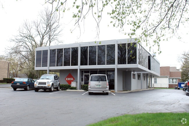
2001 E 52Nd St, Indianapolis, IN 46205


Property Detail
2001 E 52Nd St
Indianapolis-Carmel-Greenwood, IN
ROETTERS SUB L1 & L2
49-07-07-133-005.000-801
Marion
Officebuilding
Indiana
B and X Area of moderate flood hazard, usually the area between the limits of the 100-year and 500-year floods.
1,2
2024
0.29 AC
2025
Uptown
322400
Indianapolis
5,609 SF
NEARBY LISTINGS FOR SALE OR LEASE
DEMOGRAPHICS near 2001 E 52Nd St
1 mile
3 mile
5 mile
2025 Total Population
12,296
98,204
246,885
2030 Population
12,323
100,111
252,518
Pop Growth 2025-2030
+ 0.22%
+ 1.94%
+ 2.28%
Average Age
37
38
38
2025 Total Households
6,363
43,095
106,589
HH Growth 2025-2030
+ 0.16%
+ 1.84%
+ 2.26%
Median Household Inc
$67,419
$70,788
$66,952
Avg Household Size
1.90
2.10
2.20
2025 Avg HH Vehicles
2.00
2.00
2.00
Median Home Value
$274,540
$309,844
$293,225
Median Year Built
1955
1954
1959
Nearby Places
Map Layers
Map Styles
 Street
 Aerial
Layers
 Traffic
 Biking
Places
Listings with unknown addresses are not visible on the map
- Restaurants
- Banks
- Shops
- Fitness
- Groceries
PUBLIC TRANSPORTATION
COMMUTER RAIL
Drive
Walk
Distance
15 min
8.0 mi
AIRPORT
Indianapolis International
Drive
Walk
Distance
Indianapolis International
37 min
21.0 mi
SALE & LEASE HISTORY
LISTING DATE
SALE/LEASE

Sep 26, 2017
For Sale
Feb 07, 2019
For Sale
Nearby Properties
Address
Land Use
TOTAL SIZE
Lot Size
Zoning
Address
Land Use
TOTAL SIZE
Lot Size
Zoning
143,890 SF
37.81 AC
ZO01
Address
Land Use
TOTAL SIZE
Lot Size
Zoning
866 SF
14.33 AC
ZO01
Address
Land Use
TOTAL SIZE
Lot Size
Zoning
50,698 SF
13.58 AC
Address
Land Use
TOTAL SIZE
Lot Size
Zoning
76,657 SF
8.85 AC
ZO01
Address
Land Use
TOTAL SIZE
Lot Size
Zoning
207,800 SF
2.23 AC
ZO01
Address
Land Use
TOTAL SIZE
Lot Size
Zoning
25,340 SF
8.57 AC
ZO01
Address
Land Use
TOTAL SIZE
Lot Size
Zoning
2,142 SF
9.91 AC
ZO01
Address
Land Use
TOTAL SIZE
Lot Size
Zoning
3,200 SF
3.51 AC
ZO01
Address
Land Use
TOTAL SIZE
Lot Size
Zoning
23,195 SF
31.18 AC
Address
Land Use
TOTAL SIZE
Lot Size
Zoning
13,789 SF
3.93 AC
ZO01
Address
Land Use
TOTAL SIZE
Lot Size
Zoning
2,156 SF
0.46 AC
ZO01
Address
Land Use
TOTAL SIZE
Lot Size
Zoning
2,313 SF
35.45 AC
ZO01
Address
Land Use
TOTAL SIZE
Lot Size
Zoning
98,790 SF
0.18 AC
ZO01
Address
Land Use
TOTAL SIZE
Lot Size
Zoning
5,670 SF
25.69 AC
Address
Land Use
TOTAL SIZE
Lot Size
Zoning
20,746 SF
28.38 AC
ZO01
Address
Land Use
TOTAL SIZE
Lot Size
Zoning
2.81 AC
ZO01
Address
Land Use
TOTAL SIZE
Lot Size
Zoning
7,740 SF
2.04 AC
ZO01
Address
Land Use
TOTAL SIZE
Lot Size
Zoning
1,903 SF
20.77 AC
ZO01
Address
Land Use
TOTAL SIZE
Lot Size
Zoning
1,528 SF
15.64 AC
ZO01
Address
Land Use
TOTAL SIZE
Lot Size
Zoning
98,160 SF
0.65 AC
ZO01
Address
Land Use
TOTAL SIZE
Lot Size
Zoning
17,621 SF
3.20 AC
ZO01
Address
Land Use
TOTAL SIZE
Lot Size
Zoning
17,469 SF
0.87 AC
ZO01
Address
Land Use
TOTAL SIZE
Lot Size
Zoning
2,951 SF
15.45 AC
ZO01
Address
Land Use
TOTAL SIZE
Lot Size
Zoning
66,953 SF
10.87 AC
ZO01
Address
Land Use
TOTAL SIZE
Lot Size
Zoning
1,551 SF
1.23 AC
ZO01
Address
Land Use
TOTAL SIZE
Lot Size
Zoning
2,927 SF
8.75 AC
ZO01
Address
Land Use
TOTAL SIZE
Lot Size
Zoning
217,344 SF
18.58 AC
ZO01
Address
Land Use
TOTAL SIZE
Lot Size
Zoning
188,212 SF
28.51 AC
Address
Land Use
TOTAL SIZE
Lot Size
Zoning
48,300 SF
36.34 AC
Address
Land Use
TOTAL SIZE
Lot Size
Zoning
16,650 SF
1.56 AC
ZO01
The World's #1 Commercial Real Estate Marketplace
Connect with us
© 2026 CoStar Group
The information above has been obtained from sources believed reliable. While we do not doubt its accuracy we have not verified it and make no guarantee, warranty or representation about it. It is your responsibility to independently confirm its accuracy and completeness. Any projections, opinions, assumptions, or estimates used are for example only and do not represent the current or future performance of the property. The value of this transaction to you depends on tax and other factors which should be evaluated by your tax, financial, and legal advisors. You and your advisors should conduct a careful, independent investigation of the property to determine to your satisfaction the suitability of the property for your needs.