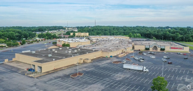
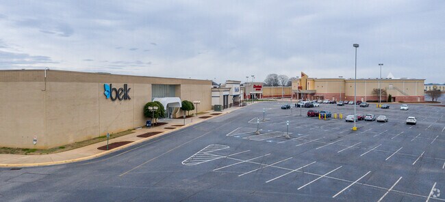
Property Record
2001 E Dixon Blvd, Shelby, NC 28152

Property Detail
2001 E Dixon Blvd
70767
30.752 AC HWY 74E CLEVE
Storebuilding
CLEVELAND
GB
North Carolina
B and X Area of moderate flood hazard, usually the area between the limits of the 100-year and 500-year floods.
1
2025
30.75 AC
2025
Cleveland County
950701
Charlotte
159,172 SF
Shelby-Kings Mountain, NC
NEARBY LISTINGS FOR SALE OR LEASE
-
-
-
-
-
-
-
No Photo
-
View all Shelby listings for sale on LoopNet.com
DEMOGRAPHICS near 2001 E Dixon Blvd
1 mile
3 mile
5 mile
2025 Total Population
1,332
13,241
39,434
2030 Population
1,358
13,524
40,321
Pop Growth 2025-2030
+ 1.95%
+ 2.14%
+ 2.25%
Average Age
40
43
42
2025 Total Households
631
5,613
16,302
HH Growth 2025-2030
+ 2.06%
+ 2.10%
+ 2.21%
Median Household Inc
$57,733
$71,947
$58,409
Avg Household Size
2.10
2.30
2.30
2025 Avg HH Vehicles
2.00
2.00
2.00
Median Home Value
$222,619
$256,715
$237,381
Median Year Built
1981
1977
1977
Nearby Places
Map Layers
Map Styles
 Street
 Aerial
Layers
 Traffic
 Biking
Places
Listings with unknown addresses are not visible on the map
- Restaurants
- Banks
- Shops
- Fitness
- Groceries
Nearby Properties
Address
Land Use
TOTAL SIZE
Lot Size
Zoning
Address
Land Use
TOTAL SIZE
Lot Size
Zoning
92,278 SF
41.63 AC
R10
Address
Land Use
TOTAL SIZE
Lot Size
Zoning
12.80 AC
R10
Address
Land Use
TOTAL SIZE
Lot Size
Zoning
29,747 SF
21.06 AC
RO
Address
Land Use
TOTAL SIZE
Lot Size
Zoning
9.55 AC
RO
Address
Land Use
TOTAL SIZE
Lot Size
Zoning
8,712 SF
13.95 AC
R6
Address
Land Use
TOTAL SIZE
Lot Size
Zoning
224,162 SF
15 AC
GBCU
Address
Land Use
TOTAL SIZE
Lot Size
Zoning
253,504 SF
30.57 AC
LI
Address
Land Use
TOTAL SIZE
Lot Size
Zoning
17,634 SF
19.06 AC
GB
Address
Land Use
TOTAL SIZE
Lot Size
Zoning
66,184 SF
56.38 AC
ROCU
Address
Land Use
TOTAL SIZE
Lot Size
Zoning
4,040 SF
22.83 AC
GB
Address
Land Use
TOTAL SIZE
Lot Size
Zoning
71,644 SF
7.67 AC
GB
Address
Land Use
TOTAL SIZE
Lot Size
Zoning
50,771 SF
2.40 AC
GB
Address
Land Use
TOTAL SIZE
Lot Size
Zoning
63,543 SF
24.07 AC
R20
Address
Land Use
TOTAL SIZE
Lot Size
Zoning
46,948 SF
2.06 AC
GB
Address
Land Use
TOTAL SIZE
Lot Size
Zoning
78,165 SF
8.02 AC
GB
Address
Land Use
TOTAL SIZE
Lot Size
Zoning
134,978 SF
14.50 AC
GB2CU
Address
Land Use
TOTAL SIZE
Lot Size
Zoning
37,580 SF
2 AC
GB
Address
Land Use
TOTAL SIZE
Lot Size
Zoning
36,511 SF
11.57 AC
GB2
Address
Land Use
TOTAL SIZE
Lot Size
Zoning
79.63 AC
R15
Address
Land Use
TOTAL SIZE
Lot Size
Zoning
24,255 SF
8.28 AC
GB2
Address
Land Use
TOTAL SIZE
Lot Size
Zoning
50,776 SF
15.10 AC
R20
Address
Land Use
TOTAL SIZE
Lot Size
Zoning
33,067 SF
3.10 AC
R6CU
Address
Land Use
TOTAL SIZE
Lot Size
Zoning
35,829 SF
4 AC
GB
Address
Land Use
TOTAL SIZE
Lot Size
Zoning
34,448 SF
1.65 AC
GB
Address
Land Use
TOTAL SIZE
Lot Size
Zoning
1,416 SF
10.74 AC
R6
Address
Land Use
TOTAL SIZE
Lot Size
Zoning
34,936 SF
5.60 AC
GB
Address
Land Use
TOTAL SIZE
Lot Size
Zoning
53,684 SF
20.06 AC
GB
Address
Land Use
TOTAL SIZE
Lot Size
Zoning
27,014 SF
9.93 AC
GB
Address
Land Use
TOTAL SIZE
Lot Size
Zoning
10,406 SF
1.68 AC
GB
The World's #1 Commercial Real Estate Marketplace
Connect with us
© 2026 CoStar Group
The information above has been obtained from sources believed reliable. While we do not doubt its accuracy we have not verified it and make no guarantee, warranty or representation about it. It is your responsibility to independently confirm its accuracy and completeness. Any projections, opinions, assumptions, or estimates used are for example only and do not represent the current or future performance of the property. The value of this transaction to you depends on tax and other factors which should be evaluated by your tax, financial, and legal advisors. You and your advisors should conduct a careful, independent investigation of the property to determine to your satisfaction the suitability of the property for your needs.