Property Record
2001 E Main St, Easley, SC 29640
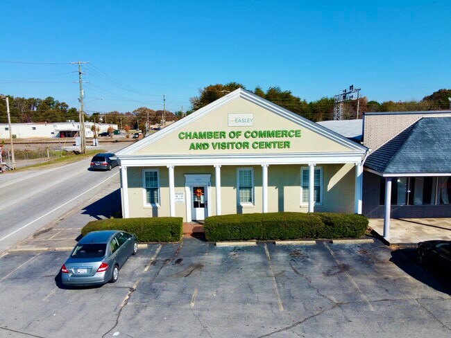

Property Detail
2001 E Main St
5029-16-93-7002
WYATT MRS L E CORNER ALLAN ST HWY 93 SEC A
Officebuilding
PICKENS
GENERAL CO
South Carolina
B and X Area of moderate flood hazard, usually the area between the limits of the 100-year and 500-year floods.
1
2025
0.34 AC
2025
Outlying Pickens County
010804
Greenville/Spartanburg
2,064 SF
Greenville-Anderson-Greer, SC
NEARBY LISTINGS FOR SALE OR LEASE
DEMOGRAPHICS near 2001 E Main St
1 mile
3 mile
5 mile
2025 Total Population
4,753
31,098
58,194
2030 Population
4,951
32,723
61,182
Pop Growth 2025-2030
+ 4.17%
+ 5.23%
+ 5.13%
Average Age
42
42
41
2025 Total Households
2,148
13,052
23,206
HH Growth 2025-2030
+ 4.42%
+ 5.48%
+ 5.43%
Median Household Inc
$57,438
$60,504
$64,323
Avg Household Size
2.20
2.30
2.50
2025 Avg HH Vehicles
2.00
2.00
2.00
Median Home Value
$286,457
$255,143
$255,611
Median Year Built
1990
1990
1990
Nearby Places
Map Layers
Map Styles
 Street
 Aerial
Transit
 Traffic
 Biking
Places
Listings with unknown addresses are not visible on the map
- Restaurants
- Banks
- Shops
- Fitness
- Groceries
SALE & LEASE HISTORY
LISTING DATE
SALE/LEASE

Dec 15, 2021
For Lease
Nearby Properties
Address
Land Use
TOTAL SIZE
Lot Size
Zoning
Address
Land Use
TOTAL SIZE
Lot Size
Zoning
81,245 SF
8.49 AC
GC
Address
Land Use
TOTAL SIZE
Lot Size
Zoning
2,291 SF
6.44 AC
GR2
Address
Land Use
TOTAL SIZE
Lot Size
Zoning
21.71 AC
GR2
Address
Land Use
TOTAL SIZE
Lot Size
Zoning
19,164 SF
3.22 AC
GC
Address
Land Use
TOTAL SIZE
Lot Size
Zoning
9,800 SF
5.94 AC
R10
Address
Land Use
TOTAL SIZE
Lot Size
Zoning
24,362 SF
3.84 AC
GENERAL CO
Address
Land Use
TOTAL SIZE
Lot Size
Zoning
19,088 SF
3 AC
CC
Address
Land Use
TOTAL SIZE
Lot Size
Zoning
10,906 SF
2.59 AC
CORE COMME
Address
Land Use
TOTAL SIZE
Lot Size
Zoning
3.60 AC
CORE COMME
Address
Land Use
TOTAL SIZE
Lot Size
Zoning
3,344 SF
3.04 AC
GR2
Address
Land Use
TOTAL SIZE
Lot Size
Zoning
162.06 AC
R10
Address
Land Use
TOTAL SIZE
Lot Size
Zoning
16.29 AC
GENERAL CO
Address
Land Use
TOTAL SIZE
Lot Size
Zoning
4,200 SF
0.98 AC
GC
Address
Land Use
TOTAL SIZE
Lot Size
Zoning
13.75 AC
GC
Address
Land Use
TOTAL SIZE
Lot Size
Zoning
6,670 SF
4 AC
GR2
Address
Land Use
TOTAL SIZE
Lot Size
Zoning
1,532 SF
9.03 AC
GR2
Address
Land Use
TOTAL SIZE
Lot Size
Zoning
3,044 SF
2 AC
GENERAL RE
Address
Land Use
TOTAL SIZE
Lot Size
Zoning
3,325 SF
16.01 AC
R10
Address
Land Use
TOTAL SIZE
Lot Size
Zoning
5,427 SF
1.34 AC
Address
Land Use
TOTAL SIZE
Lot Size
Zoning
49,803 SF
18.36 AC
GC
Address
Land Use
TOTAL SIZE
Lot Size
Zoning
3,250 SF
0.07 AC
GENERAL RE
Address
Land Use
TOTAL SIZE
Lot Size
Zoning
5,000 SF
0.12 AC
CORE COMME
Address
Land Use
TOTAL SIZE
Lot Size
Zoning
5,321 SF
3.38 AC
Address
Land Use
TOTAL SIZE
Lot Size
Zoning
220,956 SF
16.80 AC
GENERAL CO
Address
Land Use
TOTAL SIZE
Lot Size
Zoning
4,450 SF
1.28 AC
MED MEDICA
Address
Land Use
TOTAL SIZE
Lot Size
Zoning
3,867 SF
1.22 AC
CORE COMME
Address
Land Use
TOTAL SIZE
Lot Size
Zoning
36.37 AC
Address
Land Use
TOTAL SIZE
Lot Size
Zoning
20,406 SF
1.26 AC
CORE COMME
Address
Land Use
TOTAL SIZE
Lot Size
Zoning
6,314 SF
2.20 AC
GR1
Address
Land Use
TOTAL SIZE
Lot Size
Zoning
4,800 SF
0.37 AC
GENERAL CO
The World's #1 Commercial Real Estate Marketplace
Connect with us
© 2026 CoStar Group
The information above has been obtained from sources believed reliable. While we do not doubt its accuracy we have not verified it and make no guarantee, warranty or representation about it. It is your responsibility to independently confirm its accuracy and completeness. Any projections, opinions, assumptions, or estimates used are for example only and do not represent the current or future performance of the property. The value of this transaction to you depends on tax and other factors which should be evaluated by your tax, financial, and legal advisors. You and your advisors should conduct a careful, independent investigation of the property to determine to your satisfaction the suitability of the property for your needs.