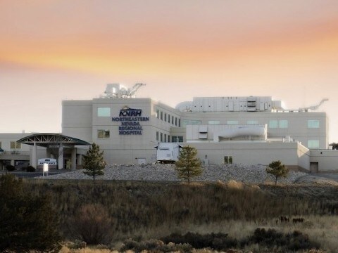
Property Record
2001 Errecart Blvd, Elko, NV 89801

Property Detail
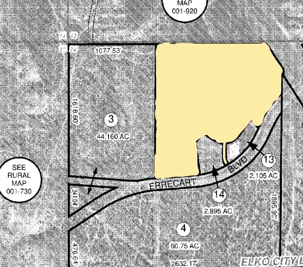
2001 Errecart Blvd
001-770-012
HOSPITAL
Hospitalpublic
Elko
ZPC
Nevada
AE The base floodplain where base flood elevations are provided. AE Zones are now used on new format FIRMs instead of A1-A30 Zones.
1
2024
45 AC
2025
Carson City/Nevada Area
951202
Other Market Areas
120,451 SF
Elko, NV
NEARBY LISTINGS FOR SALE OR LEASE
DEMOGRAPHICS near 2001 Errecart Blvd
1 mile
3 mile
5 mile
2025 Total Population
2,390
17,209
28,832
2030 Population
2,458
17,582
29,395
Pop Growth 2025-2030
+ 2.85%
+ 2.17%
+ 1.95%
Average Age
34
37
36
2025 Total Households
823
6,750
10,921
HH Growth 2025-2030
+ 2.79%
+ 2.19%
+ 1.98%
Median Household Inc
$70,743
$70,747
$79,509
Avg Household Size
2.90
2.50
2.60
2025 Avg HH Vehicles
2.00
2.00
2.00
Median Home Value
$289,551
$280,971
$275,872
Median Year Built
1994
1982
1987
Nearby Places
Map Layers
Map Styles
 Street
 Aerial
Layers
 Traffic
 Biking
Places
Listings with unknown addresses are not visible on the map
- Restaurants
- Banks
- Shops
- Fitness
- Groceries
PUBLIC TRANSPORTATION
COMMUTER RAIL
Elko Amtrak (California Zephyr - Amtrak)
Drive
Walk
Distance
Elko Amtrak (California Zephyr - Amtrak)
6 min
2.6 mi
Freight Ports
Port of Stockton
Drive
Walk
Distance
Port of Stockton
499 min
471.1 mi
Nearby Properties
Address
Land Use
TOTAL SIZE
Lot Size
Zoning
Address
Land Use
TOTAL SIZE
Lot Size
Zoning
47,730 SF
479.29 AC
MULT
Address
Land Use
TOTAL SIZE
Lot Size
Zoning
215,373 SF
14.03 AC
ZPQP
Address
Land Use
TOTAL SIZE
Lot Size
Zoning
14.71 AC
ZLI
Address
Land Use
TOTAL SIZE
Lot Size
Zoning
184,595 SF
10.79 AC
ZR
Address
Land Use
TOTAL SIZE
Lot Size
Zoning
23,552 SF
78.93 AC
MULT
Address
Land Use
TOTAL SIZE
Lot Size
Zoning
146,208 SF
36.18 AC
MULT
Address
Land Use
TOTAL SIZE
Lot Size
Zoning
89,473 SF
10.47 AC
ZC
Address
Land Use
TOTAL SIZE
Lot Size
Zoning
57,884 SF
1.89 AC
ZC
Address
Land Use
TOTAL SIZE
Lot Size
Zoning
54,982 SF
2.17 AC
ZC
Address
Land Use
TOTAL SIZE
Lot Size
Zoning
53,073 SF
2.32 AC
ZC
Address
Land Use
TOTAL SIZE
Lot Size
Zoning
3,234 SF
5.38 AC
ZC
Address
Land Use
TOTAL SIZE
Lot Size
Zoning
166,621 SF
1.40 AC
ZC
Address
Land Use
TOTAL SIZE
Lot Size
Zoning
29,193 SF
3.47 AC
ZPQP
Address
Land Use
TOTAL SIZE
Lot Size
Zoning
43,470 SF
1.82 AC
ZC
Address
Land Use
TOTAL SIZE
Lot Size
Zoning
57,628 SF
2.79 AC
ZC
Address
Land Use
TOTAL SIZE
Lot Size
Zoning
53,002 SF
3.11 AC
ZC
Address
Land Use
TOTAL SIZE
Lot Size
Zoning
96,349 SF
6.49 AC
ZC
Address
Land Use
TOTAL SIZE
Lot Size
Zoning
49,124 SF
1.50 AC
ZC
Address
Land Use
TOTAL SIZE
Lot Size
Zoning
32,520 SF
2.29 AC
ZLI
Address
Land Use
TOTAL SIZE
Lot Size
Zoning
36,897 SF
2.57 AC
ZPQP
Address
Land Use
TOTAL SIZE
Lot Size
Zoning
36,717 SF
3.49 AC
ZC
Address
Land Use
TOTAL SIZE
Lot Size
Zoning
98,533 SF
6.66 AC
MULT
Address
Land Use
TOTAL SIZE
Lot Size
Zoning
79,455 SF
9.99 AC
ZC
Address
Land Use
TOTAL SIZE
Lot Size
Zoning
34,972 SF
7.96 AC
ZPQP
Address
Land Use
TOTAL SIZE
Lot Size
Zoning
53,947 SF
5.46 AC
ZC
Address
Land Use
TOTAL SIZE
Lot Size
Zoning
51,232 SF
20.60 AC
ZPQP
Address
Land Use
TOTAL SIZE
Lot Size
Zoning
44,466 SF
4.70 AC
ZPQP
Address
Land Use
TOTAL SIZE
Lot Size
Zoning
46,950 SF
5.75 AC
ZLI
Address
Land Use
TOTAL SIZE
Lot Size
Zoning
53,252 SF
2.04 AC
ZC
The World's #1 Commercial Real Estate Marketplace
Connect with us
© 2026 CoStar Group
The information above has been obtained from sources believed reliable. While we do not doubt its accuracy we have not verified it and make no guarantee, warranty or representation about it. It is your responsibility to independently confirm its accuracy and completeness. Any projections, opinions, assumptions, or estimates used are for example only and do not represent the current or future performance of the property. The value of this transaction to you depends on tax and other factors which should be evaluated by your tax, financial, and legal advisors. You and your advisors should conduct a careful, independent investigation of the property to determine to your satisfaction the suitability of the property for your needs.