Property Record
2001 Harris St, Kelso, WA 98626

Property Detail
2001 Harris St
2-3980
817 (KELSO OUTLOT) -KEOL -213 26 -8N -2W
Multifamilydwelling
Cowlitz
R01
Washington
B and X Area of moderate flood hazard, usually the area between the limits of the 100-year and 500-year floods.
213
2025
0.91 AC
2024
Kelso
001200
Portland
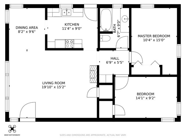
2,328 SF
Longview-Kelso, WA
NEARBY LISTINGS FOR SALE OR LEASE
DEMOGRAPHICS near 2001 Harris St
1 mile
3 mile
5 mile
2025 Total Population
6,518
34,749
65,083
2030 Population
6,620
35,469
66,272
Pop Growth 2025-2030
+ 1.56%
+ 2.07%
+ 1.83%
Average Age
40
41
41
2025 Total Households
2,616
14,035
25,800
HH Growth 2025-2030
+ 1.57%
+ 2.22%
+ 1.92%
Median Household Inc
$67,512
$65,448
$66,614
Avg Household Size
2.40
2.40
2.40
2025 Avg HH Vehicles
2.00
2.00
2.00
Median Home Value
$409,234
$385,324
$372,990
Median Year Built
1964
1966
1966
Nearby Places
Map Layers
Map Styles
 Street
 Aerial
Transit
 Traffic
 Biking
Places
Listings with unknown addresses are not visible on the map
- Restaurants
- Banks
- Shops
- Fitness
- Groceries
PUBLIC TRANSPORTATION
COMMUTER RAIL
Drive
Walk
Distance
6 min
1.7 mi
Freight Ports
Port of Long View, WA
Drive
Walk
Distance
Port of Long View, WA
15 min
5.5 mi
SALE & LEASE HISTORY
LISTING DATE
SALE/LEASE

Mar 17, 2021
For Sale
Nearby Properties
Address
Land Use
TOTAL SIZE
Lot Size
Zoning
Address
Land Use
TOTAL SIZE
Lot Size
Zoning
83,033 SF
27.78 AC
R01
Address
Land Use
TOTAL SIZE
Lot Size
Zoning
40.41 AC
R02
Address
Land Use
TOTAL SIZE
Lot Size
Zoning
10.12 AC
I01
Address
Land Use
TOTAL SIZE
Lot Size
Zoning
139,660 SF
2.76 AC
Address
Land Use
TOTAL SIZE
Lot Size
Zoning
206,926 SF
4.80 AC
C02
Address
Land Use
TOTAL SIZE
Lot Size
Zoning
2.49 AC
Address
Land Use
TOTAL SIZE
Lot Size
Zoning
28.39 AC
M02
Address
Land Use
TOTAL SIZE
Lot Size
Zoning
9.24 AC
C02
Address
Land Use
TOTAL SIZE
Lot Size
Zoning
160,069 SF
20.68 AC
M01
Address
Land Use
TOTAL SIZE
Lot Size
Zoning
48,368 SF
6.32 AC
RF1
Address
Land Use
TOTAL SIZE
Lot Size
Zoning
8.20 AC
C03
Address
Land Use
TOTAL SIZE
Lot Size
Zoning
138,715 SF
7.43 AC
C04
Address
Land Use
TOTAL SIZE
Lot Size
Zoning
157,970 SF
12.36 AC
R01
Address
Land Use
TOTAL SIZE
Lot Size
Zoning
18.59 AC
MH0
Address
Land Use
TOTAL SIZE
Lot Size
Zoning
25.61 AC
R04
Address
Land Use
TOTAL SIZE
Lot Size
Zoning
45,998 SF
1.84 AC
R01
Address
Land Use
TOTAL SIZE
Lot Size
Zoning
129,423 SF
2.34 AC
SR0
Address
Land Use
TOTAL SIZE
Lot Size
Zoning
81,854 SF
20 AC
R02
Address
Land Use
TOTAL SIZE
Lot Size
Zoning
100,505 SF
2.06 AC
C03
Address
Land Use
TOTAL SIZE
Lot Size
Zoning
117,312 SF
4.67 AC
R04
Address
Land Use
TOTAL SIZE
Lot Size
Zoning
5.11 AC
R03
Address
Land Use
TOTAL SIZE
Lot Size
Zoning
62,770 SF
6.84 AC
C03
Address
Land Use
TOTAL SIZE
Lot Size
Zoning
70,430 SF
19.88 AC
M1B
Address
Land Use
TOTAL SIZE
Lot Size
Zoning
9,020 SF
114.62 AC
I01
Address
Land Use
TOTAL SIZE
Lot Size
Zoning
2,300 SF
1.12 AC
R03
Address
Land Use
TOTAL SIZE
Lot Size
Zoning
117,064 SF
14.52 AC
M01
Address
Land Use
TOTAL SIZE
Lot Size
Zoning
3.93 AC
C02
Address
Land Use
TOTAL SIZE
Lot Size
Zoning
24,216 SF
0.39 AC
C02
Address
Land Use
TOTAL SIZE
Lot Size
Zoning
14,547 SF
1.52 AC
M1A
The World's #1 Commercial Real Estate Marketplace
Connect with us
© 2026 CoStar Group
The information above has been obtained from sources believed reliable. While we do not doubt its accuracy we have not verified it and make no guarantee, warranty or representation about it. It is your responsibility to independently confirm its accuracy and completeness. Any projections, opinions, assumptions, or estimates used are for example only and do not represent the current or future performance of the property. The value of this transaction to you depends on tax and other factors which should be evaluated by your tax, financial, and legal advisors. You and your advisors should conduct a careful, independent investigation of the property to determine to your satisfaction the suitability of the property for your needs.