Property Record
2001 Innrblt Bs Ctr Dr, Saint Louis, MO 63114
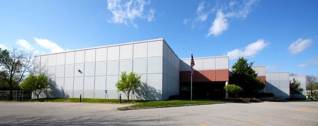


Property Detail
2001 Innrblt Bs Ctr Dr
15K-11-1113
INNERBELT BUSINESS CENTER LOTS D & E BDY ADJ LOT PT D
Warehouse
ST. LOUIS
43M-1
Missouri
B and X Area of moderate flood hazard, usually the area between the limits of the 100-year and 500-year floods.
d,e
2024
8.90 AC
2025
Innerbelt W of 170
214500
St. Louis
170,759 SF
St. Louis, MO-IL
NEARBY LISTINGS FOR SALE OR LEASE
DEMOGRAPHICS near 2001 Innrblt Bs Ctr Dr
1 mile
3 mile
5 mile
2025 Total Population
8,969
103,209
249,318
2030 Population
8,893
103,118
249,758
Pop Growth 2025-2030
(0.85%)
(0.09%)
+ 0.18%
Average Age
41
40
40
2025 Total Households
3,853
44,585
105,706
HH Growth 2025-2030
(0.96%)
(0.09%)
+ 0.05%
Median Household Inc
$60,386
$65,220
$66,318
Avg Household Size
2.30
2.20
2.20
2025 Avg HH Vehicles
2.00
2.00
2.00
Median Home Value
$134,876
$171,177
$209,721
Median Year Built
1950
1955
1956
Nearby Places
Map Layers
Map Styles
 Street
 Aerial
Layers
 Traffic
 Biking
Places
Listings with unknown addresses are not visible on the map
- Restaurants
- Banks
- Shops
- Fitness
- Groceries
PUBLIC TRANSPORTATION
COMMUTER RAIL
North Hanley (Lambert Airport Shiloh-Scott - St. Louis MetroLink (MetroLink))
Drive
Walk
Distance
North Hanley (Lambert Airport Shiloh-Scott - St. Louis MetroLink (MetroLink))
8 min
4.8 mi
Um St. Louis South (Lambert Airport Shiloh-Scott - St. Louis MetroLink (MetroLink))
Drive
Walk
Distance
Um St. Louis South (Lambert Airport Shiloh-Scott - St. Louis MetroLink (MetroLink))
9 min
4.9 mi
AIRPORT
St Louis Lambert International
Drive
Walk
Distance
St Louis Lambert International
11 min
6.5 mi
Scott AFB/Midamerica St Louis
Drive
Walk
Distance
Scott AFB/Midamerica St Louis
56 min
38.5 mi
Freight Ports
Port Milwaukee
Drive
Walk
Distance
Port Milwaukee
433 min
380.9 mi
SALE & LEASE HISTORY
LISTING DATE
SALE/LEASE

Sep 25, 2016
For Lease
Nov 27, 2019
For Lease
Nov 07, 2023
For Lease
Feb 16, 2022
For Lease
Nearby Properties
Address
Land Use
TOTAL SIZE
Lot Size
Zoning
Address
Land Use
TOTAL SIZE
Lot Size
Zoning
1,053,686 SF
31.40 AC
43M-1
Address
Land Use
TOTAL SIZE
Lot Size
Zoning
5,898 SF
21.62 AC
R2
Address
Land Use
TOTAL SIZE
Lot Size
Zoning
72,612 SF
118.34 AC
3INSTU
Address
Land Use
TOTAL SIZE
Lot Size
Zoning
52.13 AC
42PA
Address
Land Use
TOTAL SIZE
Lot Size
Zoning
201,879 SF
29.52 AC
82RO
Address
Land Use
TOTAL SIZE
Lot Size
Zoning
272,933 SF
0.82 AC
14PUD
Address
Land Use
TOTAL SIZE
Lot Size
Zoning
1,280,539 SF
151.20 AC
H
Address
Land Use
TOTAL SIZE
Lot Size
Zoning
272,940 SF
0.87 AC
14PUD
Address
Land Use
TOTAL SIZE
Lot Size
Zoning
262,446 SF
1.97 AC
14S-1
Address
Land Use
TOTAL SIZE
Lot Size
Zoning
233,748 SF
0.67 AC
14PUD
Address
Land Use
TOTAL SIZE
Lot Size
Zoning
642,298 SF
1.78 AC
14PUD
Address
Land Use
TOTAL SIZE
Lot Size
Zoning
212,613 SF
1 AC
C4
Address
Land Use
TOTAL SIZE
Lot Size
Zoning
222,517 SF
6.77 AC
C2
Address
Land Use
TOTAL SIZE
Lot Size
Zoning
134,716 SF
15.56 AC
33G
Address
Land Use
TOTAL SIZE
Lot Size
Zoning
19.40 AC
57PA
Address
Land Use
TOTAL SIZE
Lot Size
Zoning
348,233 SF
23.68 AC
Address
Land Use
TOTAL SIZE
Lot Size
Zoning
386,784 SF
6.50 AC
57HDR/O
Address
Land Use
TOTAL SIZE
Lot Size
Zoning
249,369 SF
6 AC
57HDR/O
Address
Land Use
TOTAL SIZE
Lot Size
Zoning
160,628 SF
1.47 AC
82R0
Address
Land Use
TOTAL SIZE
Lot Size
Zoning
57,010 SF
2.42 AC
57GC
Address
Land Use
TOTAL SIZE
Lot Size
Zoning
42.40 AC
M2
Address
Land Use
TOTAL SIZE
Lot Size
Zoning
309,486 SF
10.73 AC
7M-1
Address
Land Use
TOTAL SIZE
Lot Size
Zoning
35,240 SF
0.52 AC
14PUD
Address
Land Use
TOTAL SIZE
Lot Size
Zoning
277,926 SF
12.61 AC
67C-2
Address
Land Use
TOTAL SIZE
Lot Size
Zoning
14,371 SF
22.26 AC
84R-2
Address
Land Use
TOTAL SIZE
Lot Size
Zoning
172,059 SF
25.52 AC
R1
Address
Land Use
TOTAL SIZE
Lot Size
Zoning
84,072 SF
0.64 AC
14PUD
Address
Land Use
TOTAL SIZE
Lot Size
Zoning
2.89 AC
F
Address
Land Use
TOTAL SIZE
Lot Size
Zoning
151,640 SF
5.38 AC
D
Address
Land Use
TOTAL SIZE
Lot Size
Zoning
5,640 SF
10.42 AC
A
The World's #1 Commercial Real Estate Marketplace
Connect with us
© 2026 CoStar Group
The information above has been obtained from sources believed reliable. While we do not doubt its accuracy we have not verified it and make no guarantee, warranty or representation about it. It is your responsibility to independently confirm its accuracy and completeness. Any projections, opinions, assumptions, or estimates used are for example only and do not represent the current or future performance of the property. The value of this transaction to you depends on tax and other factors which should be evaluated by your tax, financial, and legal advisors. You and your advisors should conduct a careful, independent investigation of the property to determine to your satisfaction the suitability of the property for your needs.