Property Record
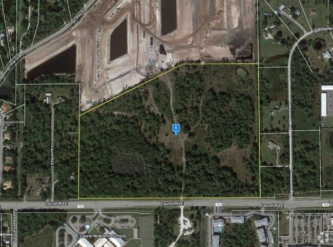
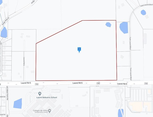
2001 Laurel Rd E, Nokomis, FL 34275

Property Detail
2001 Laurel Rd E
0380-02-0001
TRACT OF LAND LYING IN SECTION 29-38-19 BEING DESC AS COM AT NW COR OF SE COR OF SE 1/4 OF SAID SEC 29 TH S 89-34-44 E, ALONG NLY LINE OF SAID SE 1/4 OF SEC 29, A DIST OF 1352.81 FT TO THE NE COR OF
Pasture
SARASOTA
CG
Florida
AE The base floodplain where base flood elevations are provided. AE Zones are now used on new format FIRMs instead of A1-A30 Zones.
64.05 AC
2024
Sarasota
2025
Tampa/St Petersburg
002714
North Port-Bradenton-Sarasota, FL
NEARBY LISTINGS FOR SALE OR LEASE
DEMOGRAPHICS near 2001 Laurel Rd E
1 mile
3 mile
5 mile
2025 Total Population
3,107
36,935
75,109
2030 Population
3,401
40,117
81,597
Pop Growth 2025-2030
+ 9.46%
+ 8.62%
+ 8.64%
Average Age
58
60
60
2025 Total Households
1,539
18,967
38,634
HH Growth 2025-2030
+ 9.75%
+ 8.58%
+ 8.74%
Median Household Inc
$73,973
$72,602
$75,860
Avg Household Size
2.00
1.90
1.90
2025 Avg HH Vehicles
2.00
2.00
2.00
Median Home Value
$439,204
$460,833
$479,806
Median Year Built
1987
1988
1988
Nearby Places
Map Layers
Map Styles
 Street
 Aerial
Transit
 Traffic
 Biking
Places
Listings with unknown addresses are not visible on the map
- Restaurants
- Banks
- Shops
- Fitness
- Groceries
PUBLIC TRANSPORTATION
AIRPORT
Sarasota/Bradenton International
Drive
Walk
Distance
Sarasota/Bradenton International
37 min
27.2 mi
Punta Gorda
Drive
Walk
Distance
Punta Gorda
43 min
36.0 mi
Freight Ports
Port Manatee
Drive
Walk
Distance
Port Manatee
50 min
39.8 mi
SALE & LEASE HISTORY
LISTING DATE
SALE/LEASE

May 13, 2021
For Sale
Nearby Properties
Address
Land Use
TOTAL SIZE
Lot Size
Zoning
Address
Land Use
TOTAL SIZE
Lot Size
Zoning
738,835 SF
65.43 AC
LW
Address
Land Use
TOTAL SIZE
Lot Size
Zoning
26,265 SF
210.50 AC
RMH
Address
Land Use
TOTAL SIZE
Lot Size
Zoning
421,272 SF
31.96 AC
PUD
Address
Land Use
TOTAL SIZE
Lot Size
Zoning
308,834 SF
16 AC
PUD
Address
Land Use
TOTAL SIZE
Lot Size
Zoning
273,036 SF
28.76 AC
RMF3
Address
Land Use
TOTAL SIZE
Lot Size
Zoning
238,850 SF
18.24 AC
LE
Address
Land Use
TOTAL SIZE
Lot Size
Zoning
263,056 SF
25.54 AC
LW
Address
Land Use
TOTAL SIZE
Lot Size
Zoning
8,017 SF
56 AC
RMH
Address
Land Use
TOTAL SIZE
Lot Size
Zoning
181,657 SF
56.90 AC
GU
Address
Land Use
TOTAL SIZE
Lot Size
Zoning
8,562 SF
58.92 AC
RMH
Address
Land Use
TOTAL SIZE
Lot Size
Zoning
23,348 SF
77.03 AC
RMH
Address
Land Use
TOTAL SIZE
Lot Size
Zoning
190,485 SF
5.81 AC
NTG
Address
Land Use
TOTAL SIZE
Lot Size
Zoning
48,681 SF
5 AC
OPI
Address
Land Use
TOTAL SIZE
Lot Size
Zoning
177,646 SF
5.23 AC
LE
Address
Land Use
TOTAL SIZE
Lot Size
Zoning
362,000 SF
41.51 AC
PID
Address
Land Use
TOTAL SIZE
Lot Size
Zoning
1,184 SF
90 AC
PUD
Address
Land Use
TOTAL SIZE
Lot Size
Zoning
183,584 SF
14.54 AC
PUD
Address
Land Use
TOTAL SIZE
Lot Size
Zoning
133,773 SF
6.29 AC
OPI
Address
Land Use
TOTAL SIZE
Lot Size
Zoning
425,768 SF
18.41 AC
RMF2
Address
Land Use
TOTAL SIZE
Lot Size
Zoning
252,213 SF
13.49 AC
LE
Address
Land Use
TOTAL SIZE
Lot Size
Zoning
5,396 SF
33.59 AC
RMH
Address
Land Use
TOTAL SIZE
Lot Size
Zoning
5,208 SF
38.03 AC
CG
Address
Land Use
TOTAL SIZE
Lot Size
Zoning
63,549 SF
6.26 AC
OPI
Address
Land Use
TOTAL SIZE
Lot Size
Zoning
127,135 SF
12.37 AC
CG
Address
Land Use
TOTAL SIZE
Lot Size
Zoning
101,219 SF
4.90 AC
OPI
Address
Land Use
TOTAL SIZE
Lot Size
Zoning
76,247 SF
13.89 AC
CG
Address
Land Use
TOTAL SIZE
Lot Size
Zoning
110,209 SF
12.55 AC
PID
Address
Land Use
TOTAL SIZE
Lot Size
Zoning
70,220 SF
9.31 AC
LW
Address
Land Use
TOTAL SIZE
Lot Size
Zoning
115,474 SF
12.08 AC
PID
Address
Land Use
TOTAL SIZE
Lot Size
Zoning
49,400 SF
4.51 AC
OPI
The World's #1 Commercial Real Estate Marketplace
Connect with us
© 2026 CoStar Group
The information above has been obtained from sources believed reliable. While we do not doubt its accuracy we have not verified it and make no guarantee, warranty or representation about it. It is your responsibility to independently confirm its accuracy and completeness. Any projections, opinions, assumptions, or estimates used are for example only and do not represent the current or future performance of the property. The value of this transaction to you depends on tax and other factors which should be evaluated by your tax, financial, and legal advisors. You and your advisors should conduct a careful, independent investigation of the property to determine to your satisfaction the suitability of the property for your needs.