Property Record
2001 Marlin Dr, Jacksonville, NC 28546
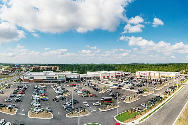


Property Detail
2001 Marlin Dr
163257
L1 GATEWAY MARKETPLACE LLC
Supermarket
Onslow
CC
North Carolina
B and X Area of moderate flood hazard, usually the area between the limits of the 100-year and 500-year floods.
1
2025
11.20 AC
2025
North Carolina Southeast Area
001304
Other Market Areas
85,609 SF
Jacksonville, NC
NEARBY LISTINGS FOR SALE OR LEASE
DEMOGRAPHICS near 2001 Marlin Dr
1 mile
3 mile
5 mile
2025 Total Population
5,383
38,712
66,934
2030 Population
5,638
40,093
69,735
Pop Growth 2025-2030
+ 4.74%
+ 3.57%
+ 4.18%
Average Age
31
34
34
2025 Total Households
2,259
15,380
25,791
HH Growth 2025-2030
+ 4.65%
+ 3.73%
+ 4.42%
Median Household Inc
$62,027
$61,482
$59,915
Avg Household Size
2.30
2.50
2.50
2025 Avg HH Vehicles
2.00
2.00
2.00
Median Home Value
$238,039
$228,508
$228,396
Median Year Built
2010
1991
1990
Nearby Places
Map Layers
Map Styles
 Street
 Aerial
Transit
 Traffic
 Biking
Places
Listings with unknown addresses are not visible on the map
- Restaurants
- Banks
- Shops
- Fitness
- Groceries
PUBLIC TRANSPORTATION
AIRPORT
Albert J Ellis
Drive
Walk
Distance
Albert J Ellis
34 min
18.2 mi
Coastal Carolina Regional
Drive
Walk
Distance
Coastal Carolina Regional
59 min
42.0 mi
Freight Ports
Port of Morehead City
Drive
Walk
Distance
Port of Morehead City
72 min
45.3 mi
SALE & LEASE HISTORY
LISTING DATE
SALE/LEASE

Sep 23, 2016
For Sale
Nov 02, 2016
For Lease
May 10, 2018
For Lease
Nearby Properties
Address
Land Use
TOTAL SIZE
Lot Size
Zoning
Address
Land Use
TOTAL SIZE
Lot Size
Zoning
244,010 SF
52.70 AC
CC
Address
Land Use
TOTAL SIZE
Lot Size
Zoning
11,192 SF
64.76 AC
OI
Address
Land Use
TOTAL SIZE
Lot Size
Zoning
164,207 SF
43.55 AC
OI
Address
Land Use
TOTAL SIZE
Lot Size
Zoning
185,000 SF
57.05 AC
OI
Address
Land Use
TOTAL SIZE
Lot Size
Zoning
5,929 SF
19.45 AC
RMF-HD
Address
Land Use
TOTAL SIZE
Lot Size
Zoning
27,193 SF
20.13 AC
RMF-HD
Address
Land Use
TOTAL SIZE
Lot Size
Zoning
87,143 SF
71.12 AC
OI
Address
Land Use
TOTAL SIZE
Lot Size
Zoning
25,860 SF
13.10 AC
RMF-HD
Address
Land Use
TOTAL SIZE
Lot Size
Zoning
1,500 SF
16.75 AC
RMF-HD
Address
Land Use
TOTAL SIZE
Lot Size
Zoning
10,560 SF
42.87 AC
RSF-7
Address
Land Use
TOTAL SIZE
Lot Size
Zoning
6,110 SF
17.20 AC
RMF-HD
Address
Land Use
TOTAL SIZE
Lot Size
Zoning
27,480 SF
16.90 AC
RMF-HD
Address
Land Use
TOTAL SIZE
Lot Size
Zoning
50,600 SF
17 AC
CC
Address
Land Use
TOTAL SIZE
Lot Size
Zoning
27,696 SF
10.15 AC
RMF-HD
Address
Land Use
TOTAL SIZE
Lot Size
Zoning
26,244 SF
13.12 AC
RMF-HD
Address
Land Use
TOTAL SIZE
Lot Size
Zoning
18,150 SF
15.65 AC
RMF-HD
Address
Land Use
TOTAL SIZE
Lot Size
Zoning
2,951 SF
16.39 AC
RMF-HD
Address
Land Use
TOTAL SIZE
Lot Size
Zoning
24,882 SF
7.30 AC
RMF-HD
Address
Land Use
TOTAL SIZE
Lot Size
Zoning
89,260 SF
30 AC
OI
Address
Land Use
TOTAL SIZE
Lot Size
Zoning
204,711 SF
9.70 AC
CC
Address
Land Use
TOTAL SIZE
Lot Size
Zoning
16,248 SF
21.09 AC
RMF-HD
Address
Land Use
TOTAL SIZE
Lot Size
Zoning
64,288 SF
35.78 AC
CC
Address
Land Use
TOTAL SIZE
Lot Size
Zoning
124,749 SF
16.31 AC
CC
Address
Land Use
TOTAL SIZE
Lot Size
Zoning
2,289 SF
7.22 AC
RMF-HD
Address
Land Use
TOTAL SIZE
Lot Size
Zoning
139,938 SF
13.87 AC
CC
Address
Land Use
TOTAL SIZE
Lot Size
Zoning
50,112 SF
4.07 AC
CC
Address
Land Use
TOTAL SIZE
Lot Size
Zoning
27,856 SF
20.11 AC
CC
Address
Land Use
TOTAL SIZE
Lot Size
Zoning
41,676 SF
16.53 AC
CC
Address
Land Use
TOTAL SIZE
Lot Size
Zoning
15,746 SF
27.64 AC
RSF-7
The World's #1 Commercial Real Estate Marketplace
Connect with us
© 2026 CoStar Group
The information above has been obtained from sources believed reliable. While we do not doubt its accuracy we have not verified it and make no guarantee, warranty or representation about it. It is your responsibility to independently confirm its accuracy and completeness. Any projections, opinions, assumptions, or estimates used are for example only and do not represent the current or future performance of the property. The value of this transaction to you depends on tax and other factors which should be evaluated by your tax, financial, and legal advisors. You and your advisors should conduct a careful, independent investigation of the property to determine to your satisfaction the suitability of the property for your needs.