Property Record
2001 Martin Luther King Jr Dr Sw, Atlanta, GA 30310

Current Lease Availabilities
NEARBY LISTINGS FOR SALE OR LEASE
Property Detail
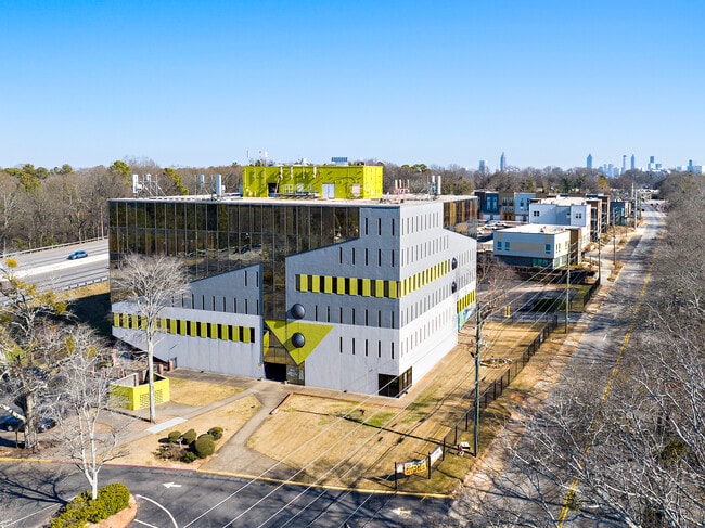
2001 Martin Luther King Jr Dr Sw
14-0173-LL-006-0
A
Officebuilding
KA OFFICE BLDG FLAG DC
X
Fulton
13121C0239F
Georgia
2024
2.15 AC
2025
West Atlanta
008104
Atlanta
84,604 SF
Atlanta-Sandy Springs-Roswell, GA
DEMOGRAPHICS near 2001 Martin Luther King Jr Dr Sw
1 Mile
3 Mile
5 Mile
2024 Total Population
10,216
101,829
309,863
2029 Population
10,888
107,287
323,486
Pop Growth 2024-2029
+ 6.58%
+ 5.36%
+ 4.40%
Average Age
40
38
36
2024 Total Households
4,083
40,087
138,742
HH Growth 2024-2029
+ 6.81%
+ 5.62%
+ 4.62%
Median Household Inc
$37,079
$39,242
$60,813
Avg Household Size
2.30
2.20
2.00
2024 Avg HH Vehicles
1.00
1.00
1.00
Median Home Value
$215,833
$272,228
$315,029
Median Year Built
1957
1967
1988
Nearby Places
- Restaurants
- Banks
- Shops
- Fitness
- Groceries
PUBLIC TRANSPORTATION
TRANSIT/SUBWAY
West Lake (Blue Line - Metropolitan Atlanta Rapid Transit Authority (MARTA))
DRIVE
WALK
Distance
West Lake (Blue Line - Metropolitan Atlanta Rapid Transit Authority (MARTA))
1 min
10 min
0.5 mi
COMMUTER RAIL
Atlanta (Crescent - Amtrak)
DRIVE
WALK
Distance
Atlanta (Crescent - Amtrak)
13 min
7.0 mi
AIRPORT
Hartsfield - Jackson Atlanta International
DRIVE
WALK
Distance
Hartsfield - Jackson Atlanta International
19 min
12.2 mi
Freight Ports
Georgia Ports - Savannah
DRIVE
WALK
Distance
Georgia Ports - Savannah
282 min
251.6 mi
Nearby Properties
Address
Land Use
TOTAL SIZE
Lot Size
Zoning
Address
Land Use
TOTAL SIZE
Lot Size
Zoning
19.94 AC
SPI1
Address
Land Use
TOTAL SIZE
Lot Size
Zoning
9.80 AC
C5
Address
Land Use
TOTAL SIZE
Lot Size
Zoning
61.57 AC
C5
Address
Land Use
TOTAL SIZE
Lot Size
Zoning
961,817 SF
25.44 AC
I2
Address
Land Use
TOTAL SIZE
Lot Size
Zoning
34 AC
OI
Address
Land Use
TOTAL SIZE
Lot Size
Zoning
2,401,682 SF
9.96 AC
I2
Address
Land Use
TOTAL SIZE
Lot Size
Zoning
418,252 SF
3.48 AC
I2
Address
Land Use
TOTAL SIZE
Lot Size
Zoning
494,100 SF
6.10 AC
I2
Address
Land Use
TOTAL SIZE
Lot Size
Zoning
564,481 SF
6.71 AC
I2
Address
Land Use
TOTAL SIZE
Lot Size
Zoning
541,508 SF
110.88 AC
I1
Address
Land Use
TOTAL SIZE
Lot Size
Zoning
9.22 AC
R4A
Address
Land Use
TOTAL SIZE
Lot Size
Zoning
322,279 SF
3.66 AC
I2
Address
Land Use
TOTAL SIZE
Lot Size
Zoning
21,834 SF
1.24 AC
I2
Address
Land Use
TOTAL SIZE
Lot Size
Zoning
857,294 SF
101.10 AC
I1
Address
Land Use
TOTAL SIZE
Lot Size
Zoning
6.16 AC
I2
Address
Land Use
TOTAL SIZE
Lot Size
Zoning
569,908 SF
2.22 AC
I1
Address
Land Use
TOTAL SIZE
Lot Size
Zoning
687,121 SF
0.07 AC
C1
Address
Land Use
TOTAL SIZE
Lot Size
Zoning
425,270 SF
201.84 AC
I1
Address
Land Use
TOTAL SIZE
Lot Size
Zoning
6.12 AC
OI
Address
Land Use
TOTAL SIZE
Lot Size
Zoning
19.31 AC
R4
Address
Land Use
TOTAL SIZE
Lot Size
Zoning
191,217 SF
1.63 AC
RG3
Address
Land Use
TOTAL SIZE
Lot Size
Zoning
5.51 AC
OI
Address
Land Use
TOTAL SIZE
Lot Size
Zoning
396,330 SF
7.02 AC
RG3
Address
Land Use
TOTAL SIZE
Lot Size
Zoning
577,662 SF
3.21 AC
I2
Address
Land Use
TOTAL SIZE
Lot Size
Zoning
1,170,962 SF
38.32 AC
C3
Address
Land Use
TOTAL SIZE
Lot Size
Zoning
12.34 AC
R4A
Address
Land Use
TOTAL SIZE
Lot Size
Zoning
19.94 AC
SPI1
Address
Land Use
TOTAL SIZE
Lot Size
Zoning
87 SF
SPI1
Address
Land Use
TOTAL SIZE
Lot Size
Zoning
34.86 AC
R4
Address
Land Use
TOTAL SIZE
Lot Size
Zoning
182,124 SF
1.99 AC
I1C
The World's #1 Commercial Real Estate Marketplace
Connect with us
© 2025 CoStar Group
The information above has been obtained from sources believed reliable. While we do not doubt its accuracy we have not verified it and make no guarantee, warranty or representation about it. It is your responsibility to independently confirm its accuracy and completeness. Any projections, opinions, assumptions, or estimates used are for example only and do not represent the current or future performance of the property. The value of this transaction to you depends on tax and other factors which should be evaluated by your tax, financial, and legal advisors. You and your advisors should conduct a careful, independent investigation of the property to determine to your satisfaction the suitability of the property for your needs.