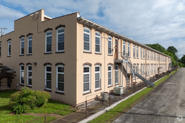
Property Record
1905 N Chamberlain Ave, Chattanooga, TN 37406

NEARBY LISTINGS FOR SALE OR LEASE
Property Detail
1905 N Chamberlain Ave
Chattanooga
Arlington Heights
Chattanooga, TN-GA
LT 27 ARLINGTON HEIGHTS PB 122 PG 106 OUT OF 136L E 011 FOR 2022
136L-E-011.01
Hamilton
Manufacturinglight
Tennessee
2025
27
2025
6.04 AC
012300
East
29,862 SF
DEMOGRAPHICS near 1905 N Chamberlain Ave
1 mile
3 mile
5 mile
2024 Total Population
7,333
54,710
145,822
2029 Population
7,948
59,094
156,558
Pop Growth 2024-2029
+ 8.39%
+ 8.01%
+ 7.36%
Average Age
37
38
39
2024 Total Households
2,890
22,221
63,242
HH Growth 2024-2029
+ 8.55%
+ 8.34%
+ 7.66%
Median Household Inc
$30,878
$46,161
$49,343
Avg Household Size
2.50
2.30
2.20
2024 Avg HH Vehicles
1.00
2.00
2.00
Median Home Value
$158,455
$229,200
$201,964
Median Year Built
1967
1964
1967
Nearby Places
Map Layers
Map Styles
 Street
 Aerial
Transit
 Traffic
 Biking
Places
Listings with unknown addresses are not visible on the map
- Restaurants
- Banks
- Shops
- Fitness
- Groceries
PUBLIC TRANSPORTATION
AIRPORT
Lovell Field
Drive
Walk
Distance
Lovell Field
18 min
7.9 mi
Freight Ports
Georgia Ports - Savannah
Drive
Walk
Distance
Georgia Ports - Savannah
410 min
364.1 mi
SALE & LEASE HISTORY
LISTING DATE
SALE/LEASE

Sep 25, 2016
For Lease
Sep 24, 2016
For Sale
May 26, 2020
For Lease
Jun 03, 2020
For Sale
Feb 28, 2024
For Sale
Apr 10, 2025
For Sale
Nearby Properties
Address
Land Use
TOTAL SIZE
Lot Size
Zoning
Address
Land Use
TOTAL SIZE
Lot Size
Zoning
728,901 SF
103.09 AC
Address
Land Use
TOTAL SIZE
Lot Size
Zoning
308,910 SF
53.60 AC
M1
Address
Land Use
TOTAL SIZE
Lot Size
Zoning
192,000 SF
3.09 AC
R4
Address
Land Use
TOTAL SIZE
Lot Size
Zoning
91,908 SF
2.64 AC
C3
Address
Land Use
TOTAL SIZE
Lot Size
Zoning
170,000 SF
2.25 AC
C3
Address
Land Use
TOTAL SIZE
Lot Size
Zoning
134,974 SF
3.22 AC
Address
Land Use
TOTAL SIZE
Lot Size
Zoning
351,776 SF
17.70 AC
R4
Address
Land Use
TOTAL SIZE
Lot Size
Zoning
308,635 SF
2.24 AC
M1
Address
Land Use
TOTAL SIZE
Lot Size
Zoning
357,029 SF
13.45 AC
C3
Address
Land Use
TOTAL SIZE
Lot Size
Zoning
75,697 SF
1.33 AC
Address
Land Use
TOTAL SIZE
Lot Size
Zoning
432,056 SF
2.54 AC
C3
Address
Land Use
TOTAL SIZE
Lot Size
Zoning
8.18 AC
9999
Address
Land Use
TOTAL SIZE
Lot Size
Zoning
438,219 SF
17.54 AC
R3
Address
Land Use
TOTAL SIZE
Lot Size
Zoning
52,209 SF
3.43 AC
C2
Address
Land Use
TOTAL SIZE
Lot Size
Zoning
87,337 SF
1.47 AC
9999
Address
Land Use
TOTAL SIZE
Lot Size
Zoning
48,465 SF
21.50 AC
Address
Land Use
TOTAL SIZE
Lot Size
Zoning
60,802 SF
1.43 AC
R4
Address
Land Use
TOTAL SIZE
Lot Size
Zoning
43,470 SF
1.26 AC
R4
Address
Land Use
TOTAL SIZE
Lot Size
Zoning
373,889 SF
3.68 AC
Address
Land Use
TOTAL SIZE
Lot Size
Zoning
118,644 SF
10.20 AC
R3
Address
Land Use
TOTAL SIZE
Lot Size
Zoning
38,267 SF
3.07 AC
M1
Address
Land Use
TOTAL SIZE
Lot Size
Zoning
13,820 SF
12 AC
R3
Address
Land Use
TOTAL SIZE
Lot Size
Zoning
81,510 SF
9.98 AC
R4
Address
Land Use
TOTAL SIZE
Lot Size
Zoning
140,200 SF
72 AC
Address
Land Use
TOTAL SIZE
Lot Size
Zoning
31,848 SF
0.75 AC
R4
Address
Land Use
TOTAL SIZE
Lot Size
Zoning
8.10 AC
Address
Land Use
TOTAL SIZE
Lot Size
Zoning
129,330 SF
2.13 AC
R4
Address
Land Use
TOTAL SIZE
Lot Size
Zoning
116,490 SF
2.75 AC
9999
Address
Land Use
TOTAL SIZE
Lot Size
Zoning
70,190 SF
6.05 AC
R4
Address
Land Use
TOTAL SIZE
Lot Size
Zoning
63,716 SF
3.55 AC
The World's #1 Commercial Real Estate Marketplace
Connect with us
© 2026 CoStar Group
The information above has been obtained from sources believed reliable. While we do not doubt its accuracy we have not verified it and make no guarantee, warranty or representation about it. It is your responsibility to independently confirm its accuracy and completeness. Any projections, opinions, assumptions, or estimates used are for example only and do not represent the current or future performance of the property. The value of this transaction to you depends on tax and other factors which should be evaluated by your tax, financial, and legal advisors. You and your advisors should conduct a careful, independent investigation of the property to determine to your satisfaction the suitability of the property for your needs.