Property Record
2001 N Harrington Rd, Parma, MI 49269

This Property Is For Sale
Property Detail
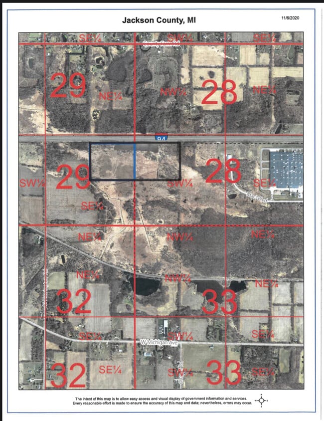
2001 N Harrington Rd
000-07-29-426-002-00
NE 1/4 OF SE 1/4 EXC THE N 250.45 FT THEREOF. SEC 29 T2S R2W 32.4000 A
Agriculturalland
Jackson
AG-1
Michigan
B and X Area of moderate flood hazard, usually the area between the limits of the 100-year and 500-year floods.
32.40 AC
2024
Jackson County
2025
West Michigan
006500
Jackson, MI
NEARBY LISTINGS FOR SALE OR LEASE
DEMOGRAPHICS near 2001 N Harrington Rd
1 mile
3 mile
5 mile
2025 Total Population
212
4,608
13,249
2030 Population
211
4,609
13,171
Pop Growth 2025-2030
(0.47%)
+ 0.02%
(0.59%)
Average Age
40
41
40
2025 Total Households
80
1,718
4,649
HH Growth 2025-2030
0.00%
(0.06%)
(0.69%)
Median Household Inc
$88,888
$90,277
$84,518
Avg Household Size
2.60
2.60
2.50
2025 Avg HH Vehicles
2.00
2.00
2.00
Median Home Value
$231,034
$229,201
$230,108
Median Year Built
1973
1975
1977
Nearby Places
Map Layers
Map Styles
 Street
 Aerial
Layers
 Traffic
 Biking
Places
Listings with unknown addresses are not visible on the map
- Restaurants
- Banks
- Shops
- Fitness
- Groceries
PUBLIC TRANSPORTATION
COMMUTER RAIL
Jackson (Wolverine - Amtrak)
Drive
Walk
Distance
Jackson (Wolverine - Amtrak)
12 min
9.5 mi
Freight Ports
Port of Toledo
Drive
Walk
Distance
Port of Toledo
113 min
89.4 mi
Nearby Properties
Address
Land Use
TOTAL SIZE
Lot Size
Zoning
Address
Land Use
TOTAL SIZE
Lot Size
Zoning
994,960 SF
93.25 AC
C-2 GEN
Address
Land Use
TOTAL SIZE
Lot Size
Zoning
35,189 SF
7.05 AC
RS-1
Address
Land Use
TOTAL SIZE
Lot Size
Zoning
5,480 SF
9.78 AC
L.I-1
Address
Land Use
TOTAL SIZE
Lot Size
Zoning
27,800 SF
3.27 AC
L.I-1
Address
Land Use
TOTAL SIZE
Lot Size
Zoning
7,488 SF
73.30 AC
AG-1
Address
Land Use
TOTAL SIZE
Lot Size
Zoning
12,078 SF
15.44 AC
C 2
Address
Land Use
TOTAL SIZE
Lot Size
Zoning
3,164 SF
140.22 AC
AG-1
Address
Land Use
TOTAL SIZE
Lot Size
Zoning
3,984 SF
48.16 AC
RM-1
Address
Land Use
TOTAL SIZE
Lot Size
Zoning
2,340 SF
140.50 AC
AG-1
Address
Land Use
TOTAL SIZE
Lot Size
Zoning
2,044 SF
157 AC
AG 1
Address
Land Use
TOTAL SIZE
Lot Size
Zoning
21,000 SF
3.18 AC
L.I-1
Address
Land Use
TOTAL SIZE
Lot Size
Zoning
4,488 SF
74 AC
AG-1
Address
Land Use
TOTAL SIZE
Lot Size
Zoning
2,170 SF
89.41 AC
AG-1
Address
Land Use
TOTAL SIZE
Lot Size
Zoning
159 AC
AG 1
Address
Land Use
TOTAL SIZE
Lot Size
Zoning
2,816 SF
80 AC
AG-1
Address
Land Use
TOTAL SIZE
Lot Size
Zoning
1,772 SF
111.76 AC
AG-1
Address
Land Use
TOTAL SIZE
Lot Size
Zoning
153.03 AC
AG-1
Address
Land Use
TOTAL SIZE
Lot Size
Zoning
14,400 SF
6.99 AC
L.I-1
Address
Land Use
TOTAL SIZE
Lot Size
Zoning
3,080 SF
60.03 AC
AG-1
Address
Land Use
TOTAL SIZE
Lot Size
Zoning
125 AC
AG 1
Address
Land Use
TOTAL SIZE
Lot Size
Zoning
7,746 SF
122.63 AC
AG-1
Address
Land Use
TOTAL SIZE
Lot Size
Zoning
1,566 SF
79.14 AC
AG-1
Address
Land Use
TOTAL SIZE
Lot Size
Zoning
135 AC
RNF1/AG1
Address
Land Use
TOTAL SIZE
Lot Size
Zoning
9,100 SF
1 AC
C 1
Address
Land Use
TOTAL SIZE
Lot Size
Zoning
1,536 SF
40 AC
AG-1
Address
Land Use
TOTAL SIZE
Lot Size
Zoning
2,032 SF
70 AC
AG-1
Address
Land Use
TOTAL SIZE
Lot Size
Zoning
2,766 SF
40 AC
AG-1
Address
Land Use
TOTAL SIZE
Lot Size
Zoning
6,492 SF
140.47 AC
M.H.PARK
Address
Land Use
TOTAL SIZE
Lot Size
Zoning
1,104 SF
81.91 AC
AG-1
Address
Land Use
TOTAL SIZE
Lot Size
Zoning
102.16 AC
AG-1
The World's #1 Commercial Real Estate Marketplace
Connect with us
© 2026 CoStar Group
The information above has been obtained from sources believed reliable. While we do not doubt its accuracy we have not verified it and make no guarantee, warranty or representation about it. It is your responsibility to independently confirm its accuracy and completeness. Any projections, opinions, assumptions, or estimates used are for example only and do not represent the current or future performance of the property. The value of this transaction to you depends on tax and other factors which should be evaluated by your tax, financial, and legal advisors. You and your advisors should conduct a careful, independent investigation of the property to determine to your satisfaction the suitability of the property for your needs.