Property Record
2001 Ne Diamond Lake Blvd, Roseburg, OR 97470
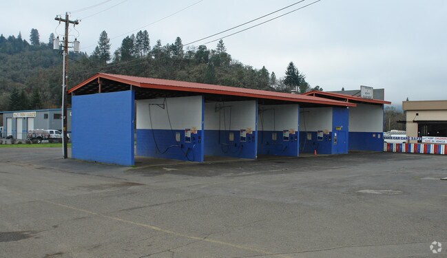

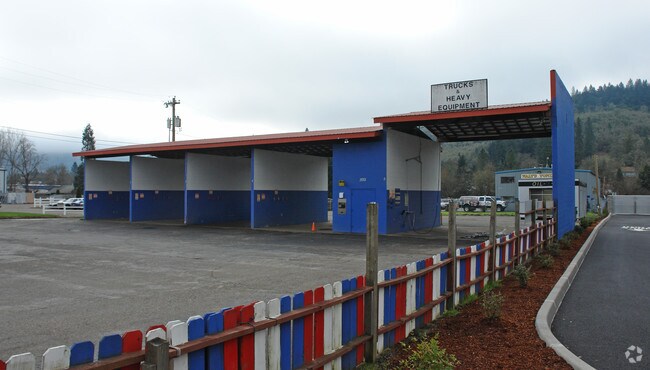
Property Detail
2001 Ne Diamond Lake Blvd
R19581
BUSHEY ADD VAC, LOT M&B INST 79-4504 (PT L 2 B 15), ACRES 0.52
Commercialnec
Douglas
MU
Oregon
AE The base floodplain where base flood elevations are provided. AE Zones are now used on new format FIRMs instead of A1-A30 Zones.
m,b,2
2025
0.52 AC
2025
Oregon West Area
120002
Other Market Areas
2,500 SF
Roseburg, OR
NEARBY LISTINGS FOR SALE OR LEASE
-
-
View all Roseburg listings for sale on LoopNet.com
DEMOGRAPHICS near 2001 Ne Diamond Lake Blvd
1 mile
3 mile
5 mile
2025 Total Population
7,361
27,634
39,299
2030 Population
7,612
28,252
39,912
Pop Growth 2025-2030
+ 3.41%
+ 2.24%
+ 1.56%
Average Age
42
43
44
2025 Total Households
3,139
11,669
16,460
HH Growth 2025-2030
+ 3.44%
+ 2.25%
+ 1.57%
Median Household Inc
$57,890
$52,621
$59,178
Avg Household Size
2.20
2.20
2.30
2025 Avg HH Vehicles
2.00
2.00
2.00
Median Home Value
$301,858
$302,059
$312,246
Median Year Built
1956
1973
1977
Nearby Places
Map Layers
Map Styles
 Street
 Aerial
Transit
 Traffic
 Biking
Places
Listings with unknown addresses are not visible on the map
- Restaurants
- Banks
- Shops
- Fitness
- Groceries
Nearby Properties
Address
Land Use
TOTAL SIZE
Lot Size
Zoning
Address
Land Use
TOTAL SIZE
Lot Size
Zoning
276,720 SF
18.77 AC
PR
Address
Land Use
TOTAL SIZE
Lot Size
Zoning
149.62 AC
PR
Address
Land Use
TOTAL SIZE
Lot Size
Zoning
1,000 SF
18.99 AC
PR
Address
Land Use
TOTAL SIZE
Lot Size
Zoning
239,143 SF
6.29 AC
PR
Address
Land Use
TOTAL SIZE
Lot Size
Zoning
102.28 AC
AP
Address
Land Use
TOTAL SIZE
Lot Size
Zoning
63.52 AC
PR
Address
Land Use
TOTAL SIZE
Lot Size
Zoning
145,644 SF
9.08 AC
MU
Address
Land Use
TOTAL SIZE
Lot Size
Zoning
199,245 SF
13.97 AC
C3
Address
Land Use
TOTAL SIZE
Lot Size
Zoning
86,285 SF
4.91 AC
C3
Address
Land Use
TOTAL SIZE
Lot Size
Zoning
152,625 SF
20.21 AC
C3
Address
Land Use
TOTAL SIZE
Lot Size
Zoning
90,785 SF
2.76 AC
PR
Address
Land Use
TOTAL SIZE
Lot Size
Zoning
1,713 SF
7 AC
MU
Address
Land Use
TOTAL SIZE
Lot Size
Zoning
230,093 SF
17.80 AC
C3
Address
Land Use
TOTAL SIZE
Lot Size
Zoning
82,532 SF
2.43 AC
C3
Address
Land Use
TOTAL SIZE
Lot Size
Zoning
40 AC
M3
Address
Land Use
TOTAL SIZE
Lot Size
Zoning
115,574 SF
4.32 AC
C3
Address
Land Use
TOTAL SIZE
Lot Size
Zoning
43,384 SF
9.16 AC
PR
Address
Land Use
TOTAL SIZE
Lot Size
Zoning
124,320 SF
13.02 AC
MR40
Address
Land Use
TOTAL SIZE
Lot Size
Zoning
103,469 SF
10.45 AC
MU
Address
Land Use
TOTAL SIZE
Lot Size
Zoning
2.11 AC
MU
Address
Land Use
TOTAL SIZE
Lot Size
Zoning
115,934 SF
3.48 AC
MR29
Address
Land Use
TOTAL SIZE
Lot Size
Zoning
119,646 SF
10.03 AC
MR18
Address
Land Use
TOTAL SIZE
Lot Size
Zoning
42,708 SF
0.78 AC
PR
Address
Land Use
TOTAL SIZE
Lot Size
Zoning
13.73 AC
M2
Address
Land Use
TOTAL SIZE
Lot Size
Zoning
89,208 SF
5.01 AC
MU
Address
Land Use
TOTAL SIZE
Lot Size
Zoning
68,135 SF
8.13 AC
C3
Address
Land Use
TOTAL SIZE
Lot Size
Zoning
4.76 AC
PR
Address
Land Use
TOTAL SIZE
Lot Size
Zoning
37,755 SF
2.80 AC
C3
Address
Land Use
TOTAL SIZE
Lot Size
Zoning
2.55 AC
M2
Address
Land Use
TOTAL SIZE
Lot Size
Zoning
129,644 SF
4.85 AC
MU
The World's #1 Commercial Real Estate Marketplace
Connect with us
© 2026 CoStar Group
The information above has been obtained from sources believed reliable. While we do not doubt its accuracy we have not verified it and make no guarantee, warranty or representation about it. It is your responsibility to independently confirm its accuracy and completeness. Any projections, opinions, assumptions, or estimates used are for example only and do not represent the current or future performance of the property. The value of this transaction to you depends on tax and other factors which should be evaluated by your tax, financial, and legal advisors. You and your advisors should conduct a careful, independent investigation of the property to determine to your satisfaction the suitability of the property for your needs.