Property Record
2001 Shepard Rd, Normal, IL 61761
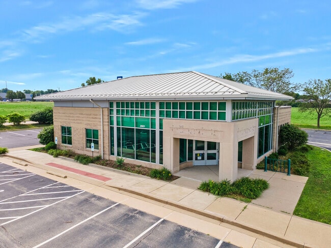


Property Detail
2001 Shepard Rd
14-23-403-005
SEC 23-24-2E RESUB LOTS 9 & 10 7TH ADD TO NORTH-LAND COMMERCIAL SUB LOT 13
Commercialnec
McLean
B1
Illinois
B and X Area of moderate flood hazard, usually the area between the limits of the 100-year and 500-year floods.
9,10,
2022
1.19 AC
2024
Bloomington/Normal
000504
Other Market Areas
3,566 SF
Bloomington, IL
NEARBY LISTINGS FOR SALE OR LEASE
DEMOGRAPHICS near 2001 Shepard Rd
1 mile
3 mile
5 mile
2024 Total Population
6,479
68,803
119,045
2029 Population
6,400
68,825
119,284
Pop Growth 2024-2029
(1.22%)
+ 0.03%
+ 0.20%
Average Age
37
36
37
2024 Total Households
2,660
26,033
48,632
HH Growth 2024-2029
(1.28%)
(0.02%)
+ 0.23%
Median Household Inc
$100,432
$80,716
$72,717
Avg Household Size
2.40
2.30
2.20
2024 Avg HH Vehicles
2.00
2.00
2.00
Median Home Value
$236,408
$244,602
$218,220
Median Year Built
1992
1989
1980
Nearby Places
Map Layers
Map Styles
 Street
 Aerial
Transit
 Traffic
 Biking
Places
Listings with unknown addresses are not visible on the map
- Restaurants
- Banks
- Shops
- Fitness
- Groceries
PUBLIC TRANSPORTATION
COMMUTER RAIL
Drive
Walk
Distance
7 min
2.8 mi
AIRPORT
Central Il Regional/Bloomington-Normal
Drive
Walk
Distance
Central Il Regional/Bloomington-Normal
13 min
5.0 mi
SALE & LEASE HISTORY
LISTING DATE
SALE/LEASE

Jul 15, 2025
For Lease
Jul 15, 2025
For Sale
Nearby Properties
Address
Land Use
TOTAL SIZE
Lot Size
Zoning
Address
Land Use
TOTAL SIZE
Lot Size
Zoning
65.47 AC
Address
Land Use
TOTAL SIZE
Lot Size
Zoning
562,852 SF
48.94 AC
Address
Land Use
TOTAL SIZE
Lot Size
Zoning
154,502 SF
1.25 AC
Address
Land Use
TOTAL SIZE
Lot Size
Zoning
493,944 SF
2.95 AC
R-3A
Address
Land Use
TOTAL SIZE
Lot Size
Zoning
445,676 SF
20.86 AC
Address
Land Use
TOTAL SIZE
Lot Size
Zoning
426,806 SF
20.93 AC
Address
Land Use
TOTAL SIZE
Lot Size
Zoning
127,569 SF
1.54 AC
Address
Land Use
TOTAL SIZE
Lot Size
Zoning
1,624,618 SF
54.32 AC
Address
Land Use
TOTAL SIZE
Lot Size
Zoning
158,508 SF
3.13 AC
R1C
Address
Land Use
TOTAL SIZE
Lot Size
Zoning
126,418 SF
1.06 AC
Address
Land Use
TOTAL SIZE
Lot Size
Zoning
177,365 SF
11.75 AC
Address
Land Use
TOTAL SIZE
Lot Size
Zoning
123,016 SF
18.52 AC
C-2
Address
Land Use
TOTAL SIZE
Lot Size
Zoning
513,218 SF
20.64 AC
R-3A
Address
Land Use
TOTAL SIZE
Lot Size
Zoning
136,382 SF
9.53 AC
Address
Land Use
TOTAL SIZE
Lot Size
Zoning
16.79 AC
Address
Land Use
TOTAL SIZE
Lot Size
Zoning
423,526 SF
25.35 AC
B-1
Address
Land Use
TOTAL SIZE
Lot Size
Zoning
208,876 SF
20.87 AC
B-1
Address
Land Use
TOTAL SIZE
Lot Size
Zoning
122,112 SF
7.16 AC
Address
Land Use
TOTAL SIZE
Lot Size
Zoning
276,695 SF
12.68 AC
Address
Land Use
TOTAL SIZE
Lot Size
Zoning
191,880 SF
3 AC
B-1
Address
Land Use
TOTAL SIZE
Lot Size
Zoning
281,134 SF
8.04 AC
R-3A
Address
Land Use
TOTAL SIZE
Lot Size
Zoning
86,950 SF
4 AC
B-1
Address
Land Use
TOTAL SIZE
Lot Size
Zoning
28,953 SF
1 AC
Address
Land Use
TOTAL SIZE
Lot Size
Zoning
98,646 SF
4 AC
B-1
Address
Land Use
TOTAL SIZE
Lot Size
Zoning
231,077 SF
15.49 AC
Address
Land Use
TOTAL SIZE
Lot Size
Zoning
197,766 SF
13.86 AC
Address
Land Use
TOTAL SIZE
Lot Size
Zoning
83.87 AC
Address
Land Use
TOTAL SIZE
Lot Size
Zoning
295,802 SF
14.99 AC
Address
Land Use
TOTAL SIZE
Lot Size
Zoning
28.92 AC
The World's #1 Commercial Real Estate Marketplace
Connect with us
© 2026 CoStar Group
The information above has been obtained from sources believed reliable. While we do not doubt its accuracy we have not verified it and make no guarantee, warranty or representation about it. It is your responsibility to independently confirm its accuracy and completeness. Any projections, opinions, assumptions, or estimates used are for example only and do not represent the current or future performance of the property. The value of this transaction to you depends on tax and other factors which should be evaluated by your tax, financial, and legal advisors. You and your advisors should conduct a careful, independent investigation of the property to determine to your satisfaction the suitability of the property for your needs.