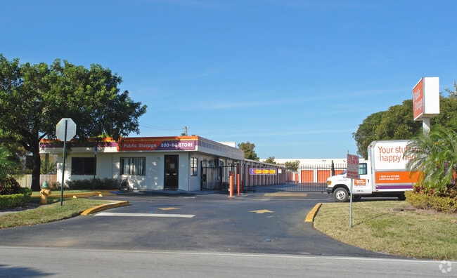
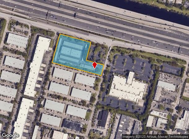
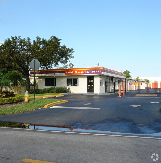
Property Record
2001 Sw 70Th Ave, Davie, FL 33317
NEARBY LISTINGS FOR SALE OR LEASE
Property Detail
2001 Sw 70Th Ave
50-41-15-20-0010
M.M.R.T. Plat 132-40 B
Publicstorage
M.M.R.T. PLAT 132-40 B PARCEL A THAT PART BEG SW COR, NELY 333.47, SELY 365.21, SWLY 209.79, SELY 209.79, SWLY 123.59, NWLY 575 TO POB
AH
Broward
12011C0551J
Florida
2024
3.40 AC
2025
Plantation
070204
South Florida
67,150 SF
Fort Lauderdale-Pompano Beach-Deerfield Beach, FL
DEMOGRAPHICS near 2001 Sw 70Th Ave
1 Mile
3 Mile
5 Mile
2024 Total Population
10,538
105,394
351,566
2029 Population
10,302
104,733
348,212
Pop Growth 2024-2029
(2.24%)
(0.63%)
(0.95%)
Average Age
38
39
39
2024 Total Households
3,841
40,182
128,265
HH Growth 2024-2029
(2.99%)
(1.03%)
(1.34%)
Median Household Inc
$89,713
$74,063
$64,334
Avg Household Size
2.40
2.50
2.60
2024 Avg HH Vehicles
2.00
2.00
2.00
Median Home Value
$428,245
$365,265
$335,992
Median Year Built
1978
1980
1977
Nearby Places
Map Layers
Map Styles
 Street
 Aerial
- Restaurants
- Banks
- Shops
- Fitness
- Groceries
PUBLIC TRANSPORTATION
COMMUTER RAIL
Fort Lauderdale/Hollywood International Airport (Mangonia Park - Miami Airport - Tri-Rail, Tri-County Commuter - Tri-Rail, West Palm Beach - MiamiCentral - Tri-Rail)
DRIVE
WALK
Distance
Fort Lauderdale/Hollywood International Airport (Mangonia Park - Miami Airport - Tri-Rail, Tri-County Commuter - Tri-Rail, West Palm Beach - MiamiCentral - Tri-Rail)
13 min
6.6 mi
Fort Lauderdale (Tri-County Commuter - South Florida Regional Transportation Authority (Tri-Rail))
DRIVE
WALK
Distance
Fort Lauderdale (Tri-County Commuter - South Florida Regional Transportation Authority (Tri-Rail))
15 min
7.2 mi
AIRPORT
Fort Lauderdale/Hollywood International
DRIVE
WALK
Distance
Fort Lauderdale/Hollywood International
13 min
6.5 mi
Miami International
DRIVE
WALK
Distance
Miami International
46 min
32.5 mi
Freight Ports
Port Everglades
DRIVE
WALK
Distance
Port Everglades
13 min
7.1 mi
Nearby Properties
Address
Land Use
TOTAL SIZE
Lot Size
Zoning
Address
Land Use
TOTAL SIZE
Lot Size
Zoning
4,069,966 SF
161.58 AC
RAC-AV
Address
Land Use
TOTAL SIZE
Lot Size
Zoning
589,748 SF
27.34 AC
RAC-RTE
Address
Land Use
TOTAL SIZE
Lot Size
Zoning
663,255 SF
3.15 AC
RAC-CC
Address
Land Use
TOTAL SIZE
Lot Size
Zoning
1,357,572 SF
126.23 AC
RAC-ED
Address
Land Use
TOTAL SIZE
Lot Size
Zoning
550,907 SF
26.92 AC
RAC-RTE
Address
Land Use
TOTAL SIZE
Lot Size
Zoning
627,368 SF
4.33 AC
PRD-21Q
Address
Land Use
TOTAL SIZE
Lot Size
Zoning
507,890 SF
39.49 AC
M-PM
Address
Land Use
TOTAL SIZE
Lot Size
Zoning
475,897 SF
14.91 AC
RAC-RTE
Address
Land Use
TOTAL SIZE
Lot Size
Zoning
413,123 SF
63.50 AC
B-3
Address
Land Use
TOTAL SIZE
Lot Size
Zoning
438,123 SF
47.44 AC
RM-22
Address
Land Use
TOTAL SIZE
Lot Size
Zoning
409,340 SF
15.49 AC
RAC-RTE
Address
Land Use
TOTAL SIZE
Lot Size
Zoning
613,363 SF
6.24 AC
B-7Q
Address
Land Use
TOTAL SIZE
Lot Size
Zoning
517,961 SF
3.92 AC
M-PM
Address
Land Use
TOTAL SIZE
Lot Size
Zoning
635,706 SF
9.58 AC
GRIFFIN CO
Address
Land Use
TOTAL SIZE
Lot Size
Zoning
497,004 SF
4.46 AC
M-PM
Address
Land Use
TOTAL SIZE
Lot Size
Zoning
456,384 SF
81.33 AC
RAC-ED
Address
Land Use
TOTAL SIZE
Lot Size
Zoning
471,109 SF
5.57 AC
M-PM
Address
Land Use
TOTAL SIZE
Lot Size
Zoning
576,167 SF
27 AC
RAC-RTE
Address
Land Use
TOTAL SIZE
Lot Size
Zoning
527,086 SF
2.34 AC
M-PM
Address
Land Use
TOTAL SIZE
Lot Size
Zoning
334,723 SF
7.47 AC
RAC-AV
Address
Land Use
TOTAL SIZE
Lot Size
Zoning
339,273 SF
20.48 AC
RM-16
Address
Land Use
TOTAL SIZE
Lot Size
Zoning
350,663 SF
16.86 AC
RAC-RTE
Address
Land Use
TOTAL SIZE
Lot Size
Zoning
356,053 SF
8.12 AC
RAC-RTE
Address
Land Use
TOTAL SIZE
Lot Size
Zoning
320,919 SF
27.70 AC
M-PM
Address
Land Use
TOTAL SIZE
Lot Size
Zoning
439,908 SF
13.54 AC
OP-P
Address
Land Use
TOTAL SIZE
Lot Size
Zoning
505,730 SF
18.07 AC
RAC-AV
Address
Land Use
TOTAL SIZE
Lot Size
Zoning
292,581 SF
13.64 AC
RM-16
Address
Land Use
TOTAL SIZE
Lot Size
Zoning
312,067 SF
20.94 AC
PRD-15Q
Address
Land Use
TOTAL SIZE
Lot Size
Zoning
289,523 SF
9.44 AC
B-HCS
Address
Land Use
TOTAL SIZE
Lot Size
Zoning
321,240 SF
2.16 AC
M-PM
The World's #1 Commercial Real Estate Marketplace
Connect with us
© 2025 CoStar Group
The information above has been obtained from sources believed reliable. While we do not doubt its accuracy we have not verified it and make no guarantee, warranty or representation about it. It is your responsibility to independently confirm its accuracy and completeness. Any projections, opinions, assumptions, or estimates used are for example only and do not represent the current or future performance of the property. The value of this transaction to you depends on tax and other factors which should be evaluated by your tax, financial, and legal advisors. You and your advisors should conduct a careful, independent investigation of the property to determine to your satisfaction the suitability of the property for your needs.