Property Record
2001 The Oaks Pkwy, , NC


Property Detail
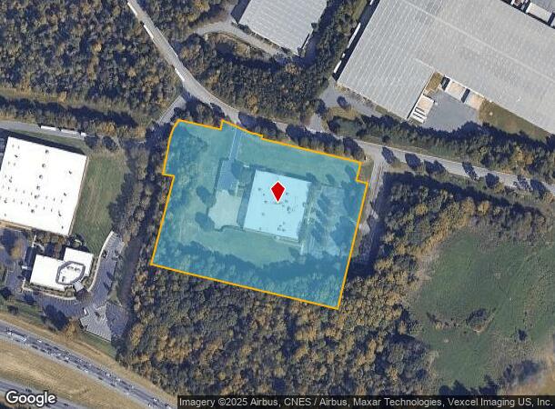
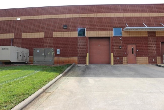
2001 The Oaks Pkwy
199497
Plat Of Kidsco Llc Map 1 R L Stowe Mills
Warehouse
KIDSCO LLC NLN 15 023 022 00 000
X
Gaston
3710358500J
North Carolina
2025
8.16 AC
2025
Gaston County
0312021012
Charlotte
42,096 SF
Charlotte-Concord-Gastonia, NC-SC
NEARBY LISTINGS FOR SALE OR LEASE
DEMOGRAPHICS near 2001 The Oaks Pkwy
1 mile
3 mile
5 mile
2024 Total Population
3,564
37,979
88,198
2029 Population
3,845
40,880
94,601
Pop Growth 2024-2029
+ 7.88%
+ 7.64%
+ 7.26%
Average Age
38
40
40
2024 Total Households
1,484
16,318
35,641
HH Growth 2024-2029
+ 8.36%
+ 7.86%
+ 7.46%
Median Household Inc
$51,920
$55,188
$66,171
Avg Household Size
2.20
2.30
2.40
2024 Avg HH Vehicles
2.00
2.00
2.00
Median Home Value
$171,865
$228,569
$243,293
Median Year Built
1978
1985
1988
Nearby Places
Map Layers
Map Styles
 Street
 Aerial
Transit
 Traffic
 Biking
Places
Listings with unknown addresses are not visible on the map
- Restaurants
- Banks
- Shops
- Fitness
- Groceries
PUBLIC TRANSPORTATION
COMMUTER RAIL
Drive
Walk
Distance
17 min
9.2 mi
AIRPORT
Charlotte/Douglas International
Drive
Walk
Distance
Charlotte/Douglas International
26 min
10.9 mi
Concord-Padgett Regional
Drive
Walk
Distance
Concord-Padgett Regional
40 min
24.3 mi
SALE & LEASE HISTORY
LISTING DATE
SALE/LEASE

Oct 25, 2021
For Lease
Jul 23, 2019
For Lease
Jul 23, 2019
For Sale
Nearby Properties
Address
Land Use
TOTAL SIZE
Lot Size
Zoning
Address
Land Use
TOTAL SIZE
Lot Size
Zoning
37.49 AC
Address
Land Use
TOTAL SIZE
Lot Size
Zoning
41,508 SF
29.70 AC
Address
Land Use
TOTAL SIZE
Lot Size
Zoning
1,886 SF
39.30 AC
Address
Land Use
TOTAL SIZE
Lot Size
Zoning
25,137 SF
34.81 AC
Address
Land Use
TOTAL SIZE
Lot Size
Zoning
1,066 SF
70.67 AC
PUB01
Address
Land Use
TOTAL SIZE
Lot Size
Zoning
6.09 AC
Address
Land Use
TOTAL SIZE
Lot Size
Zoning
43.38 AC
Address
Land Use
TOTAL SIZE
Lot Size
Zoning
1,966 SF
36.06 AC
OFF01
Address
Land Use
TOTAL SIZE
Lot Size
Zoning
30,906 SF
14.19 AC
Address
Land Use
TOTAL SIZE
Lot Size
Zoning
25.64 AC
Address
Land Use
TOTAL SIZE
Lot Size
Zoning
23,899 SF
14.57 AC
HC
Address
Land Use
TOTAL SIZE
Lot Size
Zoning
98.12 AC
Address
Land Use
TOTAL SIZE
Lot Size
Zoning
171,037 SF
4.37 AC
Address
Land Use
TOTAL SIZE
Lot Size
Zoning
77,111 SF
105.80 AC
R3
Address
Land Use
TOTAL SIZE
Lot Size
Zoning
25.14 AC
Address
Land Use
TOTAL SIZE
Lot Size
Zoning
4,552 SF
9.22 AC
R1
Address
Land Use
TOTAL SIZE
Lot Size
Zoning
358,450 SF
23.50 AC
STOR2
Address
Land Use
TOTAL SIZE
Lot Size
Zoning
3,536 SF
12.07 AC
APT02
Address
Land Use
TOTAL SIZE
Lot Size
Zoning
190,498 SF
20.10 AC
RET05
Address
Land Use
TOTAL SIZE
Lot Size
Zoning
13,800 SF
58.55 AC
PUB01
Address
Land Use
TOTAL SIZE
Lot Size
Zoning
48,452 SF
18.08 AC
PUB03
Address
Land Use
TOTAL SIZE
Lot Size
Zoning
46,998 SF
30.47 AC
HCAR1
Address
Land Use
TOTAL SIZE
Lot Size
Zoning
2,000 SF
2.19 AC
Address
Land Use
TOTAL SIZE
Lot Size
Zoning
516,688 SF
36.23 AC
STOR2
Address
Land Use
TOTAL SIZE
Lot Size
Zoning
44,718 SF
26.53 AC
OFF10
Address
Land Use
TOTAL SIZE
Lot Size
Zoning
1,596 SF
5.73 AC
OFF01
Address
Land Use
TOTAL SIZE
Lot Size
Zoning
65,513 SF
3.07 AC
Address
Land Use
TOTAL SIZE
Lot Size
Zoning
139,155 SF
15.13 AC
RET05
Address
Land Use
TOTAL SIZE
Lot Size
Zoning
99.28 AC
BCD
Address
Land Use
TOTAL SIZE
Lot Size
Zoning
118,896 SF
3.98 AC
The World's #1 Commercial Real Estate Marketplace
Connect with us
© 2026 CoStar Group
The information above has been obtained from sources believed reliable. While we do not doubt its accuracy we have not verified it and make no guarantee, warranty or representation about it. It is your responsibility to independently confirm its accuracy and completeness. Any projections, opinions, assumptions, or estimates used are for example only and do not represent the current or future performance of the property. The value of this transaction to you depends on tax and other factors which should be evaluated by your tax, financial, and legal advisors. You and your advisors should conduct a careful, independent investigation of the property to determine to your satisfaction the suitability of the property for your needs.