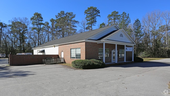
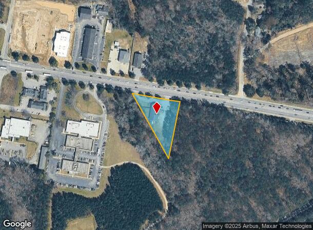
Property Record
2001 W Dekalb St, Camden, SC 29020
NEARBY LISTINGS FOR SALE OR LEASE
Property Detail
2001 W Dekalb St
284-00-00-016
JD-2276 IY-462 JA-241 US NO 1 3500
Officebuilding
Kershaw
X
South Carolina
45055C0435F
1.29 AC
2025
Kershaw County
2025
Columbia
970800
Columbia, SC
5,050 SF
DEMOGRAPHICS near 2001 W Dekalb St
1 Mile
3 Mile
5 Mile
2024 Total Population
1,537
12,060
23,786
2029 Population
1,703
13,233
25,981
Pop Growth 2024-2029
+ 10.80%
+ 9.73%
+ 9.23%
Average Age
40
43
42
2024 Total Households
629
5,129
9,831
HH Growth 2024-2029
+ 10.97%
+ 9.57%
+ 9.10%
Median Household Inc
$34,085
$38,987
$42,155
Avg Household Size
2.30
2.30
2.30
2024 Avg HH Vehicles
1.00
2.00
2.00
Median Home Value
$153,703
$185,612
$164,222
Median Year Built
1978
1976
1981
Nearby Places
Map Layers
Map Styles
 Street
 Aerial
- Restaurants
- Banks
- Shops
- Fitness
- Groceries
SALE & LEASE HISTORY
LISTING DATE
SALE/LEASE

Feb 27, 2017
For Lease
Nearby Properties
Address
Land Use
TOTAL SIZE
Lot Size
Zoning
Address
Land Use
TOTAL SIZE
Lot Size
Zoning
15.09 AC
MUNICIPAL
Address
Land Use
TOTAL SIZE
Lot Size
Zoning
183,825 SF
20.09 AC
MUNICIPAL
Address
Land Use
TOTAL SIZE
Lot Size
Zoning
117,844 SF
12.21 AC
MUNICIPAL
Address
Land Use
TOTAL SIZE
Lot Size
Zoning
141,018 SF
8.44 AC
MUNICIPAL
Address
Land Use
TOTAL SIZE
Lot Size
Zoning
116,508 SF
14.91 AC
MUNICIPAL
Address
Land Use
TOTAL SIZE
Lot Size
Zoning
101,650 SF
8.48 AC
Address
Land Use
TOTAL SIZE
Lot Size
Zoning
47,718 SF
4.56 AC
MUNICIPAL
Address
Land Use
TOTAL SIZE
Lot Size
Zoning
85,915 SF
3.57 AC
MUNICIPAL
Address
Land Use
TOTAL SIZE
Lot Size
Zoning
37,794 SF
28.77 AC
GD
Address
Land Use
TOTAL SIZE
Lot Size
Zoning
60,023 SF
5.70 AC
B2
Address
Land Use
TOTAL SIZE
Lot Size
Zoning
36,380 SF
3.61 AC
MUNICIPAL
Address
Land Use
TOTAL SIZE
Lot Size
Zoning
75,636 SF
6.28 AC
MUNICIPAL
Address
Land Use
TOTAL SIZE
Lot Size
Zoning
72,502 SF
12 AC
GD
Address
Land Use
TOTAL SIZE
Lot Size
Zoning
37,872 SF
6.53 AC
B2
Address
Land Use
TOTAL SIZE
Lot Size
Zoning
41,160 SF
3.37 AC
Address
Land Use
TOTAL SIZE
Lot Size
Zoning
15,214 SF
1.28 AC
MUNICIPAL
Address
Land Use
TOTAL SIZE
Lot Size
Zoning
71,157 SF
7.19 AC
MUNICIPAL
Address
Land Use
TOTAL SIZE
Lot Size
Zoning
66,678 SF
5.28 AC
R6
Address
Land Use
TOTAL SIZE
Lot Size
Zoning
20.23 AC
MUNICIPAL
Address
Land Use
TOTAL SIZE
Lot Size
Zoning
82,125 SF
8.42 AC
GD
Address
Land Use
TOTAL SIZE
Lot Size
Zoning
22,076 SF
3.53 AC
MUNICIPAL
Address
Land Use
TOTAL SIZE
Lot Size
Zoning
54,906 SF
4.51 AC
Address
Land Use
TOTAL SIZE
Lot Size
Zoning
8,804 SF
0.73 AC
Address
Land Use
TOTAL SIZE
Lot Size
Zoning
8,480 SF
3.75 AC
GD
Address
Land Use
TOTAL SIZE
Lot Size
Zoning
80,614 SF
7.70 AC
MUNICIPAL
Address
Land Use
TOTAL SIZE
Lot Size
Zoning
91,301 SF
7.32 AC
MUNICIPAL
Address
Land Use
TOTAL SIZE
Lot Size
Zoning
29.23 AC
MUNICIPAL
Address
Land Use
TOTAL SIZE
Lot Size
Zoning
64,714 SF
5.93 AC
B2
Address
Land Use
TOTAL SIZE
Lot Size
Zoning
20,359 SF
5.39 AC
RD2
Address
Land Use
TOTAL SIZE
Lot Size
Zoning
40,804 SF
3 AC
MUNICIPAL
The World's #1 Commercial Real Estate Marketplace
Connect with us
© 2025 CoStar Group
The information above has been obtained from sources believed reliable. While we do not doubt its accuracy we have not verified it and make no guarantee, warranty or representation about it. It is your responsibility to independently confirm its accuracy and completeness. Any projections, opinions, assumptions, or estimates used are for example only and do not represent the current or future performance of the property. The value of this transaction to you depends on tax and other factors which should be evaluated by your tax, financial, and legal advisors. You and your advisors should conduct a careful, independent investigation of the property to determine to your satisfaction the suitability of the property for your needs.