Property Record
2001 W Iris Dr Se, Conyers, GA 30013


Property Detail
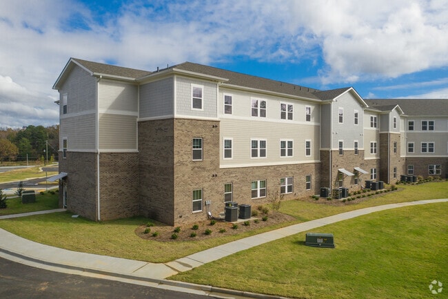
2001 W Iris Dr Se
076-0-01-0030
FLAT SHOALS RD
Apartment
Rockdale
MXD/CID/MU
Georgia
B and X Area of moderate flood hazard, usually the area between the limits of the 100-year and 500-year floods.
9.63 AC
2025
Rockdale County
2025
Atlanta
060305
Atlanta-Sandy Springs-Roswell, GA
177,123 SF
NEARBY LISTINGS FOR SALE OR LEASE
DEMOGRAPHICS near 2001 W Iris Dr Se
1 mile
3 mile
5 mile
2025 Total Population
5,094
45,283
98,458
2030 Population
5,421
47,835
104,074
Pop Growth 2025-2030
+ 6.42%
+ 5.64%
+ 5.70%
Average Age
37
39
39
2025 Total Households
1,849
16,339
34,792
HH Growth 2025-2030
+ 6.71%
+ 5.88%
+ 5.89%
Median Household Inc
$52,931
$73,683
$78,851
Avg Household Size
2.70
2.70
2.80
2025 Avg HH Vehicles
2.00
2.00
2.00
Median Home Value
$298,417
$302,485
$287,779
Median Year Built
1996
1993
1994
Nearby Places
Map Layers
Map Styles
 Street
 Aerial
Layers
 Traffic
 Biking
Places
Listings with unknown addresses are not visible on the map
- Restaurants
- Banks
- Shops
- Fitness
- Groceries
PUBLIC TRANSPORTATION
AIRPORT
Hartsfield - Jackson Atlanta International
Drive
Walk
Distance
Hartsfield - Jackson Atlanta International
43 min
31.8 mi
Freight Ports
Georgia Ports - Savannah
Drive
Walk
Distance
Georgia Ports - Savannah
274 min
237.4 mi
Nearby Properties
Address
Land Use
TOTAL SIZE
Lot Size
Zoning
Address
Land Use
TOTAL SIZE
Lot Size
Zoning
6,092 SF
37.63 AC
RM
Address
Land Use
TOTAL SIZE
Lot Size
Zoning
4,162 SF
37.52 AC
R3
Address
Land Use
TOTAL SIZE
Lot Size
Zoning
5,212 SF
21.33 AC
GV-UV
Address
Land Use
TOTAL SIZE
Lot Size
Zoning
22,362 SF
28.90 AC
MXD
Address
Land Use
TOTAL SIZE
Lot Size
Zoning
447,440 SF
47.74 AC
ID
Address
Land Use
TOTAL SIZE
Lot Size
Zoning
1,648 SF
25.08 AC
C1
Address
Land Use
TOTAL SIZE
Lot Size
Zoning
882,960 SF
0.01 AC
Address
Land Use
TOTAL SIZE
Lot Size
Zoning
140,292 SF
23.74 AC
HSB
Address
Land Use
TOTAL SIZE
Lot Size
Zoning
454,480 SF
52.17 AC
ID
Address
Land Use
TOTAL SIZE
Lot Size
Zoning
324,975 SF
35.98 AC
M1
Address
Land Use
TOTAL SIZE
Lot Size
Zoning
3,046 SF
32.01 AC
RM
Address
Land Use
TOTAL SIZE
Lot Size
Zoning
3,256 SF
22.05 AC
RM
Address
Land Use
TOTAL SIZE
Lot Size
Zoning
135,000 SF
24.77 AC
M1
Address
Land Use
TOTAL SIZE
Lot Size
Zoning
165,171 SF
49.79 AC
BG/ID
Address
Land Use
TOTAL SIZE
Lot Size
Zoning
175,605 SF
39.99 AC
AR
Address
Land Use
TOTAL SIZE
Lot Size
Zoning
3,066 SF
22.44 AC
R3/R1
Address
Land Use
TOTAL SIZE
Lot Size
Zoning
33,216 SF
8.26 AC
MXD/CID/MU
Address
Land Use
TOTAL SIZE
Lot Size
Zoning
8,268 SF
46.94 AC
R3
Address
Land Use
TOTAL SIZE
Lot Size
Zoning
17,056 SF
16.78 AC
C1
Address
Land Use
TOTAL SIZE
Lot Size
Zoning
3,648 SF
26.50 AC
R3/R1
Address
Land Use
TOTAL SIZE
Lot Size
Zoning
210,380 SF
15.86 AC
ID
Address
Land Use
TOTAL SIZE
Lot Size
Zoning
131,111 SF
22.17 AC
R3
Address
Land Use
TOTAL SIZE
Lot Size
Zoning
77,600 SF
9 AC
GVUV
Address
Land Use
TOTAL SIZE
Lot Size
Zoning
180,890 SF
45.15 AC
R1
Address
Land Use
TOTAL SIZE
Lot Size
Zoning
205,716 SF
22.88 AC
ID
Address
Land Use
TOTAL SIZE
Lot Size
Zoning
140,850 SF
19.09 AC
ID
Address
Land Use
TOTAL SIZE
Lot Size
Zoning
6,561 SF
7.49 AC
GVUV
Address
Land Use
TOTAL SIZE
Lot Size
Zoning
472,620 SF
55.20 AC
RS10
Address
Land Use
TOTAL SIZE
Lot Size
Zoning
200,943 SF
18.32 AC
M1
The World's #1 Commercial Real Estate Marketplace
Connect with us
© 2026 CoStar Group
The information above has been obtained from sources believed reliable. While we do not doubt its accuracy we have not verified it and make no guarantee, warranty or representation about it. It is your responsibility to independently confirm its accuracy and completeness. Any projections, opinions, assumptions, or estimates used are for example only and do not represent the current or future performance of the property. The value of this transaction to you depends on tax and other factors which should be evaluated by your tax, financial, and legal advisors. You and your advisors should conduct a careful, independent investigation of the property to determine to your satisfaction the suitability of the property for your needs.