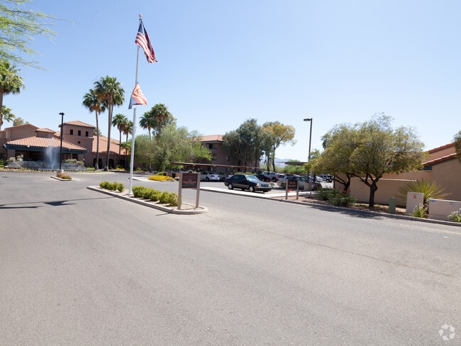
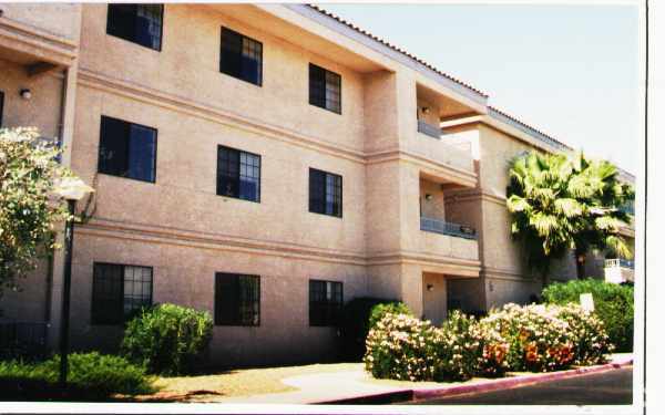
Property Record
2001 W Rudasill Rd, Tucson, AZ 85704


Save to a Folder
{{folder.Name}}
{{folder.ListingIds.length}} Properties
{{folder.ListingIds.length}} Property
Create a New Folder
Property Detail
2001 W Rudasill Rd
102-13-012C
FOUNTAINS AT LA CHOLLA BLK 3
Retirementnursinghomecombined
Pima
SR
Arizona
B and X Area of moderate flood hazard, usually the area between the limits of the 100-year and 500-year floods.
100
2025
9.49 AC
2026
North Tucson/Oro Valley
004616
Tucson
241,436 SF
Tucson, AZ
NEARBY LISTINGS FOR SALE OR LEASE
DEMOGRAPHICS near 2001 W Rudasill Rd
1 mile
3 mile
5 mile
2025 Total Population
9,267
69,681
178,473
2030 Population
9,473
71,420
183,748
Pop Growth 2025-2030
+ 2.22%
+ 2.50%
+ 2.96%
Average Age
42
42
41
2025 Total Households
3,594
30,133
78,042
HH Growth 2025-2030
+ 2.53%
+ 2.58%
+ 3.04%
Median Household Inc
$88,213
$65,613
$63,793
Avg Household Size
2.30
2.20
2.20
2025 Avg HH Vehicles
2.00
2.00
2.00
Median Home Value
$360,630
$297,316
$335,601
Median Year Built
1991
1982
1984
Nearby Places
Map Layers
Map Styles
 Street
 Aerial
Layers
 Traffic
 Biking
Places
Listings with unknown addresses are not visible on the map
- Restaurants
- Banks
- Shops
- Fitness
- Groceries
PUBLIC TRANSPORTATION
COMMUTER RAIL
Tucson Amtrak Station (Sunset Limited - Amtrak, Texas Eagle - Amtrak)
Drive
Walk
Distance
Tucson Amtrak Station (Sunset Limited - Amtrak, Texas Eagle - Amtrak)
15 min
9.8 mi
AIRPORT
Tucson International
Drive
Walk
Distance
Tucson International
28 min
17.3 mi
Freight Ports
Port of San Diego
Drive
Walk
Distance
Port of San Diego
428 min
402.7 mi
Nearby Properties
Address
Land Use
TOTAL SIZE
Lot Size
Zoning
Address
Land Use
TOTAL SIZE
Lot Size
Zoning
369,656 SF
12.62 AC
SP
Address
Land Use
TOTAL SIZE
Lot Size
Zoning
106,852 SF
19.50 AC
I1
Address
Land Use
TOTAL SIZE
Lot Size
Zoning
64,134 SF
9.58 AC
SR
Address
Land Use
TOTAL SIZE
Lot Size
Zoning
35,300 SF
5.20 AC
SR
Address
Land Use
TOTAL SIZE
Lot Size
Zoning
451,596 SF
18.92 AC
C3
Address
Land Use
TOTAL SIZE
Lot Size
Zoning
39,508 SF
7.29 AC
MU
Address
Land Use
TOTAL SIZE
Lot Size
Zoning
50,340 SF
14.37 AC
HI
Address
Land Use
TOTAL SIZE
Lot Size
Zoning
398,608 SF
22.49 AC
Address
Land Use
TOTAL SIZE
Lot Size
Zoning
131,575 SF
25.97 AC
SR
Address
Land Use
TOTAL SIZE
Lot Size
Zoning
251,043 SF
14.96 AC
Address
Land Use
TOTAL SIZE
Lot Size
Zoning
119,165 SF
21.85 AC
I1
Address
Land Use
TOTAL SIZE
Lot Size
Zoning
290,039 SF
1.98 AC
C3
Address
Land Use
TOTAL SIZE
Lot Size
Zoning
0.82 AC
Address
Land Use
TOTAL SIZE
Lot Size
Zoning
5,618 SF
3.15 AC
Address
Land Use
TOTAL SIZE
Lot Size
Zoning
373,887 SF
28.70 AC
CR4
Address
Land Use
TOTAL SIZE
Lot Size
Zoning
388,226 SF
22 AC
CR5
Address
Land Use
TOTAL SIZE
Lot Size
Zoning
21,126 SF
49.39 AC
CR1
Address
Land Use
TOTAL SIZE
Lot Size
Zoning
312,586 SF
28.73 AC
Address
Land Use
TOTAL SIZE
Lot Size
Zoning
310,258 SF
17.11 AC
TR
Address
Land Use
TOTAL SIZE
Lot Size
Zoning
24,100 SF
4.96 AC
MU
Address
Land Use
TOTAL SIZE
Lot Size
Zoning
21,000 SF
9.34 AC
Address
Land Use
TOTAL SIZE
Lot Size
Zoning
280,281 SF
12.85 AC
TR
Address
Land Use
TOTAL SIZE
Lot Size
Zoning
209,131 SF
18.55 AC
CB2
Address
Land Use
TOTAL SIZE
Lot Size
Zoning
318,278 SF
18.26 AC
TR
Address
Land Use
TOTAL SIZE
Lot Size
Zoning
19,892 SF
3.36 AC
CB1
Address
Land Use
TOTAL SIZE
Lot Size
Zoning
223,640 SF
18.06 AC
CB1
Address
Land Use
TOTAL SIZE
Lot Size
Zoning
277,576 SF
13.49 AC
TR
Address
Land Use
TOTAL SIZE
Lot Size
Zoning
239,374 SF
11.65 AC
TR
Address
Land Use
TOTAL SIZE
Lot Size
Zoning
222,779 SF
8.83 AC
CR5
Address
Land Use
TOTAL SIZE
Lot Size
Zoning
189,753 SF
18.18 AC
VC
The World's #1 Commercial Real Estate Marketplace
Connect with us
© 2026 CoStar Group
The information above has been obtained from sources believed reliable. While we do not doubt its accuracy we have not verified it and make no guarantee, warranty or representation about it. It is your responsibility to independently confirm its accuracy and completeness. Any projections, opinions, assumptions, or estimates used are for example only and do not represent the current or future performance of the property. The value of this transaction to you depends on tax and other factors which should be evaluated by your tax, financial, and legal advisors. You and your advisors should conduct a careful, independent investigation of the property to determine to your satisfaction the suitability of the property for your needs.