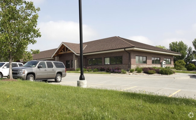
Property Record
20010 Manderson St, Elkhorn, NE 68022


NEARBY LISTINGS FOR SALE OR LEASE
Property Detail
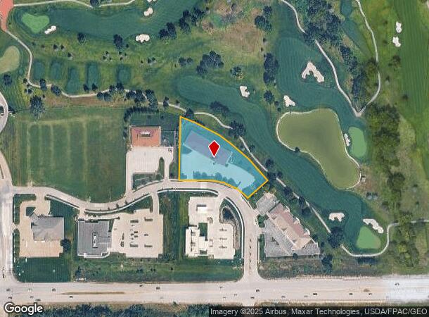
20010 Manderson St
Omaha-Council Bluffs, NE-IA
Indian Creek Business Park
1438-1110-14
INDIAN CREEK BUSINESS PARK LOT 6 BLOCK 0 IRREG 1.51AC
Officebuilding
Douglas
X
Nebraska
31055C0186J
6
2024
1.51 AC
2025
Northwest Omaha
007522
Omaha/Council Bluffs
10,528 SF
DEMOGRAPHICS near 20010 Manderson St
1 Mile
3 Mile
5 Mile
2024 Total Population
8,115
39,648
117,365
2029 Population
8,357
40,619
119,710
Pop Growth 2024-2029
+ 2.98%
+ 2.45%
+ 2.00%
Average Age
37
36
38
2024 Total Households
3,039
14,362
42,396
HH Growth 2024-2029
+ 3.16%
+ 2.52%
+ 1.92%
Median Household Inc
$98,736
$119,971
$119,362
Avg Household Size
2.60
2.70
2.70
2024 Avg HH Vehicles
2.00
2.00
2.00
Median Home Value
$324,058
$342,432
$324,651
Median Year Built
2008
2009
2003
Nearby Places
Map Layers
Map Styles
 Street
 Aerial
- Restaurants
- Banks
- Shops
- Fitness
- Groceries
PUBLIC TRANSPORTATION
AIRPORT
Eppley Airfield
DRIVE
WALK
Distance
Eppley Airfield
40 min
23.1 mi
Lincoln
DRIVE
WALK
Distance
Lincoln
61 min
49.5 mi
SALE & LEASE HISTORY
LISTING DATE
SALE/LEASE

Jun 26, 2019
For Lease
Jun 26, 2019
For Sale
Jul 13, 2023
For Lease
Nearby Properties
Address
Land Use
TOTAL SIZE
Lot Size
Zoning
Address
Land Use
TOTAL SIZE
Lot Size
Zoning
443,045 SF
22.82 AC
Address
Land Use
TOTAL SIZE
Lot Size
Zoning
486,568 SF
51.70 AC
ELKHORN
Address
Land Use
TOTAL SIZE
Lot Size
Zoning
420,483 SF
18.51 AC
R6
Address
Land Use
TOTAL SIZE
Lot Size
Zoning
362,573 SF
2.01 AC
Address
Land Use
TOTAL SIZE
Lot Size
Zoning
223,975 SF
11.91 AC
Address
Land Use
TOTAL SIZE
Lot Size
Zoning
301,689 SF
8.82 AC
Address
Land Use
TOTAL SIZE
Lot Size
Zoning
241,312 SF
14.51 AC
Address
Land Use
TOTAL SIZE
Lot Size
Zoning
226,792 SF
8.97 AC
GO
Address
Land Use
TOTAL SIZE
Lot Size
Zoning
226,780 SF
8.23 AC
Address
Land Use
TOTAL SIZE
Lot Size
Zoning
232,559 SF
13.53 AC
R6
Address
Land Use
TOTAL SIZE
Lot Size
Zoning
215,645 SF
5.19 AC
Address
Land Use
TOTAL SIZE
Lot Size
Zoning
233,520 SF
15.39 AC
Address
Land Use
TOTAL SIZE
Lot Size
Zoning
355,421 SF
18.66 AC
Address
Land Use
TOTAL SIZE
Lot Size
Zoning
168,896 SF
8.79 AC
MU
Address
Land Use
TOTAL SIZE
Lot Size
Zoning
137,800 SF
6.69 AC
Address
Land Use
TOTAL SIZE
Lot Size
Zoning
143,817 SF
12.27 AC
Address
Land Use
TOTAL SIZE
Lot Size
Zoning
149,113 SF
7.64 AC
R6
Address
Land Use
TOTAL SIZE
Lot Size
Zoning
108,211 SF
6.53 AC
Address
Land Use
TOTAL SIZE
Lot Size
Zoning
107,052 SF
5.55 AC
Address
Land Use
TOTAL SIZE
Lot Size
Zoning
149,976 SF
7.15 AC
Address
Land Use
TOTAL SIZE
Lot Size
Zoning
169,105 SF
14.11 AC
Address
Land Use
TOTAL SIZE
Lot Size
Zoning
136,279 SF
5.65 AC
Address
Land Use
TOTAL SIZE
Lot Size
Zoning
190,673 SF
10.74 AC
Address
Land Use
TOTAL SIZE
Lot Size
Zoning
108,552 SF
6.87 AC
R5
Address
Land Use
TOTAL SIZE
Lot Size
Zoning
286,114 SF
10.39 AC
Address
Land Use
TOTAL SIZE
Lot Size
Zoning
241,480 SF
9.54 AC
Address
Land Use
TOTAL SIZE
Lot Size
Zoning
137,953 SF
6.01 AC
Address
Land Use
TOTAL SIZE
Lot Size
Zoning
207,693 SF
21.62 AC
MU
Address
Land Use
TOTAL SIZE
Lot Size
Zoning
171,808 SF
17.77 AC
Address
Land Use
TOTAL SIZE
Lot Size
Zoning
134,188 SF
6.05 AC
The World's #1 Commercial Real Estate Marketplace
Connect with us
© 2025 CoStar Group
The information above has been obtained from sources believed reliable. While we do not doubt its accuracy we have not verified it and make no guarantee, warranty or representation about it. It is your responsibility to independently confirm its accuracy and completeness. Any projections, opinions, assumptions, or estimates used are for example only and do not represent the current or future performance of the property. The value of this transaction to you depends on tax and other factors which should be evaluated by your tax, financial, and legal advisors. You and your advisors should conduct a careful, independent investigation of the property to determine to your satisfaction the suitability of the property for your needs.