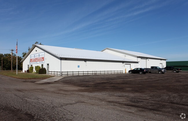
Property Record
20017 172Nd St Nw, Big Lake, MN 55309


NEARBY LISTINGS FOR SALE OR LEASE
-
-
View all Big Lake listings for sale on LoopNet.com
Property Detail
20017 172Nd St Nw
10-121-4201
THE W 480 FT OF THAT PT OF NW 1-4 OF SE 1-4 WHICH LIES S OF N 567 FT OF SAID NW 1-4 OF SE 1-4 & WHICH LIES N OF THE N R-O-W LINE OF U.S. HIGHWAY NO.10. SUBJECT TO THE R-O-W OF A TWP RD NOW KNOW AS 172ND ST NW ALONG THE W LINE THEREOF. ALSO SUBJECT TO
Industrialgeneral
Sherburne
X
Minnesota
27141C0355F
6.64 AC
2025
Sherburne County
2025
Minneapolis/St Paul
030409
Minneapolis-St. Paul-Bloomington, MN-WI
540 SF
DEMOGRAPHICS near 20017 172Nd St Nw
1 Mile
3 Mile
5 Mile
2024 Total Population
882
13,251
36,413
2029 Population
957
14,517
40,047
Pop Growth 2024-2029
+ 8.50%
+ 9.55%
+ 9.98%
Average Age
37
37
37
2024 Total Households
309
4,663
12,572
HH Growth 2024-2029
+ 8.41%
+ 9.59%
+ 10.10%
Median Household Inc
$115,234
$96,776
$100,771
Avg Household Size
2.90
2.80
2.80
2024 Avg HH Vehicles
3.00
2.00
2.00
Median Home Value
$308,403
$271,659
$290,558
Median Year Built
1985
1991
1993
Nearby Places
Map Layers
Map Styles
 Street
 Aerial
- Restaurants
- Banks
- Shops
- Fitness
- Groceries
PUBLIC TRANSPORTATION
COMMUTER RAIL
Big Lake Station (Northstar Corridor - Northstar Commuter Rail)
DRIVE
WALK
Distance
Big Lake Station (Northstar Corridor - Northstar Commuter Rail)
8 min
3.0 mi
Freight Ports
Port Milwaukee
DRIVE
WALK
Distance
Port Milwaukee
415 min
374.2 mi
Nearby Properties
Address
Land Use
TOTAL SIZE
Lot Size
Zoning
Address
Land Use
TOTAL SIZE
Lot Size
Zoning
240 SF
129.53 AC
Address
Land Use
TOTAL SIZE
Lot Size
Zoning
105,842 SF
36.08 AC
Address
Land Use
TOTAL SIZE
Lot Size
Zoning
160 SF
17.83 AC
Address
Land Use
TOTAL SIZE
Lot Size
Zoning
4.72 AC
Address
Land Use
TOTAL SIZE
Lot Size
Zoning
2.63 AC
Address
Land Use
TOTAL SIZE
Lot Size
Zoning
Address
Land Use
TOTAL SIZE
Lot Size
Zoning
1.22 AC
Address
Land Use
TOTAL SIZE
Lot Size
Zoning
49,234 SF
20.74 AC
Address
Land Use
TOTAL SIZE
Lot Size
Zoning
7,600 SF
16.16 AC
Address
Land Use
TOTAL SIZE
Lot Size
Zoning
2.49 AC
Address
Land Use
TOTAL SIZE
Lot Size
Zoning
154,440 SF
21.53 AC
A
Address
Land Use
TOTAL SIZE
Lot Size
Zoning
416 SF
6.91 AC
Address
Land Use
TOTAL SIZE
Lot Size
Zoning
1.33 AC
Address
Land Use
TOTAL SIZE
Lot Size
Zoning
3.23 AC
Address
Land Use
TOTAL SIZE
Lot Size
Zoning
2.73 AC
Address
Land Use
TOTAL SIZE
Lot Size
Zoning
18,752 SF
3.92 AC
Address
Land Use
TOTAL SIZE
Lot Size
Zoning
3.79 AC
Address
Land Use
TOTAL SIZE
Lot Size
Zoning
2.18 AC
Address
Land Use
TOTAL SIZE
Lot Size
Zoning
896 SF
7.03 AC
Address
Land Use
TOTAL SIZE
Lot Size
Zoning
3.21 AC
Address
Land Use
TOTAL SIZE
Lot Size
Zoning
1.26 AC
Address
Land Use
TOTAL SIZE
Lot Size
Zoning
32,469 SF
4.61 AC
A
Address
Land Use
TOTAL SIZE
Lot Size
Zoning
10,200 SF
19.57 AC
A
Address
Land Use
TOTAL SIZE
Lot Size
Zoning
Address
Land Use
TOTAL SIZE
Lot Size
Zoning
4,064 SF
5.49 AC
Address
Land Use
TOTAL SIZE
Lot Size
Zoning
4,408 SF
3.44 AC
Address
Land Use
TOTAL SIZE
Lot Size
Zoning
1,776 SF
3.06 AC
Address
Land Use
TOTAL SIZE
Lot Size
Zoning
224 SF
28.40 AC
Address
Land Use
TOTAL SIZE
Lot Size
Zoning
41,810 SF
15.08 AC
The World's #1 Commercial Real Estate Marketplace
Connect with us
© 2026 CoStar Group
The information above has been obtained from sources believed reliable. While we do not doubt its accuracy we have not verified it and make no guarantee, warranty or representation about it. It is your responsibility to independently confirm its accuracy and completeness. Any projections, opinions, assumptions, or estimates used are for example only and do not represent the current or future performance of the property. The value of this transaction to you depends on tax and other factors which should be evaluated by your tax, financial, and legal advisors. You and your advisors should conduct a careful, independent investigation of the property to determine to your satisfaction the suitability of the property for your needs.