Property Record
2002 Albany St, Beech Grove, IN 46107

NEARBY LISTINGS FOR SALE OR LEASE
-
-
View all Beech Grove listings for sale on LoopNet.com
Property Detail
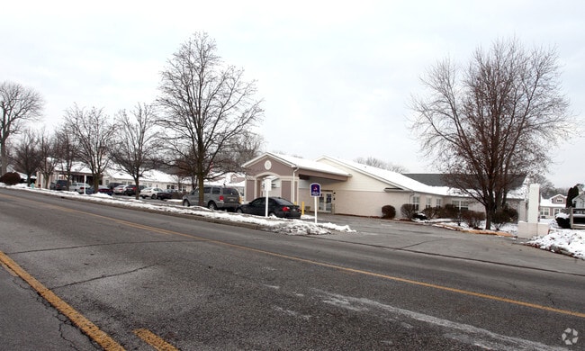
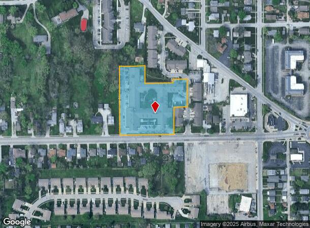
2002 Albany St
49-10-20-124-009.000-102
Irr Tr 321.46Ft Sl X 439.94Ft Wl X 192.2
Hospitalprivate
IRR TR 321.46FT SL X 439.94FT WL X 192.28FT ELBEG 167.38FT E OF SW COR W1/2 SW1/4 S20 T15N R4ECONT 2.937AC+-
X
Marion
18097C0251F
Indiana
2023
2.92 AC
2024
Beech Grove/SE County
357500
Indianapolis
57,113 SF
Indianapolis-Carmel-Anderson, IN
DEMOGRAPHICS near 2002 Albany St
1 Mile
3 Mile
5 Mile
2024 Total Population
10,454
92,205
238,394
2029 Population
10,255
91,681
237,679
Pop Growth 2024-2029
(1.90%)
(0.57%)
(0.30%)
Average Age
40
37
37
2024 Total Households
4,162
36,695
98,572
HH Growth 2024-2029
(2.04%)
(0.64%)
(0.28%)
Median Household Inc
$59,342
$53,027
$58,702
Avg Household Size
2.40
2.40
2.30
2024 Avg HH Vehicles
2.00
2.00
2.00
Median Home Value
$135,359
$150,741
$176,865
Median Year Built
1957
1959
1961
Nearby Places
Map Layers
Map Styles
 Street
 Aerial
- Restaurants
- Banks
- Shops
- Fitness
- Groceries
PUBLIC TRANSPORTATION
COMMUTER RAIL
Indianapolis (Cardinal - Amtrak)
DRIVE
WALK
Distance
Indianapolis (Cardinal - Amtrak)
9 min
4.9 mi
AIRPORT
Indianapolis International
DRIVE
WALK
Distance
Indianapolis International
29 min
15.6 mi
Freight Ports
Port of Toledo
DRIVE
WALK
Distance
Port of Toledo
274 min
227.9 mi
Nearby Properties
Address
Land Use
TOTAL SIZE
Lot Size
Zoning
Address
Land Use
TOTAL SIZE
Lot Size
Zoning
41.83 AC
ZO01
Address
Land Use
TOTAL SIZE
Lot Size
Zoning
1,202,700 SF
77.25 AC
ZO01
Address
Land Use
TOTAL SIZE
Lot Size
Zoning
19,927 SF
28.82 AC
ZO01
Address
Land Use
TOTAL SIZE
Lot Size
Zoning
9,888 SF
124.20 AC
ZO01
Address
Land Use
TOTAL SIZE
Lot Size
Zoning
80,348 SF
2.95 AC
ZO01
Address
Land Use
TOTAL SIZE
Lot Size
Zoning
1,812 SF
11.08 AC
ZO01
Address
Land Use
TOTAL SIZE
Lot Size
Zoning
3.82 AC
ZO01
Address
Land Use
TOTAL SIZE
Lot Size
Zoning
405,664 SF
35.56 AC
ZO01
Address
Land Use
TOTAL SIZE
Lot Size
Zoning
51,196 SF
50.61 AC
ZO01
Address
Land Use
TOTAL SIZE
Lot Size
Zoning
352,000 SF
22.72 AC
ZO01
Address
Land Use
TOTAL SIZE
Lot Size
Zoning
3,003 SF
3.52 AC
ZO01
Address
Land Use
TOTAL SIZE
Lot Size
Zoning
1,660 SF
15.01 AC
ZO01
Address
Land Use
TOTAL SIZE
Lot Size
Zoning
39,618 SF
8.17 AC
ZO01
Address
Land Use
TOTAL SIZE
Lot Size
Zoning
2,331 SF
1.38 AC
ZO01
Address
Land Use
TOTAL SIZE
Lot Size
Zoning
405 SF
23.81 AC
ZO01
Address
Land Use
TOTAL SIZE
Lot Size
Zoning
2,486 SF
13.75 AC
ZO01
Address
Land Use
TOTAL SIZE
Lot Size
Zoning
3,280 SF
1.04 AC
ZO01
Address
Land Use
TOTAL SIZE
Lot Size
Zoning
4,179 SF
28.11 AC
ZO01
Address
Land Use
TOTAL SIZE
Lot Size
Zoning
4,212 SF
16 AC
Address
Land Use
TOTAL SIZE
Lot Size
Zoning
208,224 SF
23.41 AC
ZO01
Address
Land Use
TOTAL SIZE
Lot Size
Zoning
4,872 SF
12.37 AC
Address
Land Use
TOTAL SIZE
Lot Size
Zoning
1,575 SF
10.24 AC
Address
Land Use
TOTAL SIZE
Lot Size
Zoning
1,040 SF
15.62 AC
ZO01
Address
Land Use
TOTAL SIZE
Lot Size
Zoning
9,160 SF
2.54 AC
ZO01
Address
Land Use
TOTAL SIZE
Lot Size
Zoning
220,708 SF
26.81 AC
ZO01
Address
Land Use
TOTAL SIZE
Lot Size
Zoning
101,122 SF
16.44 AC
Address
Land Use
TOTAL SIZE
Lot Size
Zoning
38,598 SF
2.83 AC
ZO01
Address
Land Use
TOTAL SIZE
Lot Size
Zoning
209,756 SF
12.33 AC
ZO01
Address
Land Use
TOTAL SIZE
Lot Size
Zoning
87,807 SF
9.04 AC
ZO01
Address
Land Use
TOTAL SIZE
Lot Size
Zoning
151,946 SF
15.04 AC
The World's #1 Commercial Real Estate Marketplace
Connect with us
© 2025 CoStar Group
The information above has been obtained from sources believed reliable. While we do not doubt its accuracy we have not verified it and make no guarantee, warranty or representation about it. It is your responsibility to independently confirm its accuracy and completeness. Any projections, opinions, assumptions, or estimates used are for example only and do not represent the current or future performance of the property. The value of this transaction to you depends on tax and other factors which should be evaluated by your tax, financial, and legal advisors. You and your advisors should conduct a careful, independent investigation of the property to determine to your satisfaction the suitability of the property for your needs.