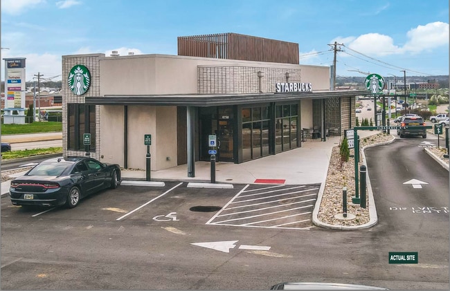
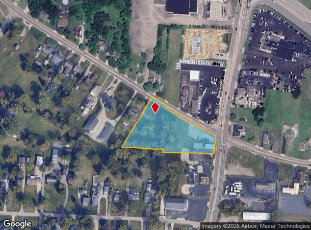
Property Record
2002 Cincinnati Dayton Rd, Middletown, OH 45044

NEARBY LISTINGS FOR SALE OR LEASE
Property Detail
2002 Cincinnati Dayton Rd
Q6542-107-000-027
18705 ENT
Restaurantbuilding
Butler
X
Ohio
39165C0102F
1.27 AC
2024
Butler County
2024
Cincinnati/Dayton
014100
Cincinnati, OH-KY-IN
3,528 SF
DEMOGRAPHICS near 2002 Cincinnati Dayton Rd
1 Mile
3 Mile
5 Mile
2024 Total Population
7,567
39,718
90,688
2029 Population
7,855
41,213
94,559
Pop Growth 2024-2029
+ 3.81%
+ 3.76%
+ 4.27%
Average Age
40
41
40
2024 Total Households
3,325
16,603
36,103
HH Growth 2024-2029
+ 3.82%
+ 3.66%
+ 4.27%
Median Household Inc
$54,725
$59,971
$60,553
Avg Household Size
2.20
2.30
2.40
2024 Avg HH Vehicles
2.00
2.00
2.00
Median Home Value
$153,837
$164,541
$170,385
Median Year Built
1978
1969
1970
Nearby Places
- Restaurants
- Banks
- Shops
- Fitness
- Groceries
PUBLIC TRANSPORTATION
AIRPORT
James M Cox Dayton International
DRIVE
WALK
Distance
James M Cox Dayton International
46 min
34.9 mi
Freight Ports
Port of Toledo
DRIVE
WALK
Distance
Port of Toledo
203 min
175.1 mi
SALE & LEASE HISTORY
LISTING DATE
SALE/LEASE

Sep 15, 2025
For Sale
Oct 06, 2025
For Sale
May 05, 2025
For Sale
Jun 23, 2025
For Sale
Jun 02, 2025
For Sale
Jul 19, 2024
For Sale
Aug 25, 2025
For Sale
Apr 15, 2025
For Sale
Nearby Properties
Address
Land Use
TOTAL SIZE
Lot Size
Zoning
Address
Land Use
TOTAL SIZE
Lot Size
Zoning
160,701 SF
10.83 AC
Address
Land Use
TOTAL SIZE
Lot Size
Zoning
Address
Land Use
TOTAL SIZE
Lot Size
Zoning
369,922 SF
28.10 AC
Address
Land Use
TOTAL SIZE
Lot Size
Zoning
9,224 SF
16.21 AC
Address
Land Use
TOTAL SIZE
Lot Size
Zoning
5,000 SF
60.29 AC
Address
Land Use
TOTAL SIZE
Lot Size
Zoning
833,210 SF
57.88 AC
Address
Land Use
TOTAL SIZE
Lot Size
Zoning
57.88 AC
Address
Land Use
TOTAL SIZE
Lot Size
Zoning
9,224 SF
16.21 AC
Address
Land Use
TOTAL SIZE
Lot Size
Zoning
7.18 AC
Address
Land Use
TOTAL SIZE
Lot Size
Zoning
27,780 SF
1.20 AC
Address
Land Use
TOTAL SIZE
Lot Size
Zoning
369,922 SF
28.10 AC
Address
Land Use
TOTAL SIZE
Lot Size
Zoning
24,808 SF
3.26 AC
Address
Land Use
TOTAL SIZE
Lot Size
Zoning
2,221 SF
7.84 AC
Address
Land Use
TOTAL SIZE
Lot Size
Zoning
16.57 AC
Address
Land Use
TOTAL SIZE
Lot Size
Zoning
Address
Land Use
TOTAL SIZE
Lot Size
Zoning
120,685 SF
21.52 AC
Address
Land Use
TOTAL SIZE
Lot Size
Zoning
478,217 SF
61.13 AC
Address
Land Use
TOTAL SIZE
Lot Size
Zoning
14,325 SF
1.84 AC
Address
Land Use
TOTAL SIZE
Lot Size
Zoning
37,842 SF
13.68 AC
Address
Land Use
TOTAL SIZE
Lot Size
Zoning
17.24 AC
ADV
Address
Land Use
TOTAL SIZE
Lot Size
Zoning
93,289 SF
11.43 AC
Address
Land Use
TOTAL SIZE
Lot Size
Zoning
75,384 SF
25.80 AC
Address
Land Use
TOTAL SIZE
Lot Size
Zoning
86.47 AC
ADV
Address
Land Use
TOTAL SIZE
Lot Size
Zoning
190,295 SF
21.70 AC
Address
Land Use
TOTAL SIZE
Lot Size
Zoning
20,250 SF
3.28 AC
Address
Land Use
TOTAL SIZE
Lot Size
Zoning
109,584 SF
9.77 AC
Address
Land Use
TOTAL SIZE
Lot Size
Zoning
113,241 SF
7.84 AC
Address
Land Use
TOTAL SIZE
Lot Size
Zoning
12,500 SF
32.38 AC
MXUC
Address
Land Use
TOTAL SIZE
Lot Size
Zoning
111,304 SF
19.53 AC
Address
Land Use
TOTAL SIZE
Lot Size
Zoning
64.34 AC
The World's #1 Commercial Real Estate Marketplace
Connect with us
© 2025 CoStar Group
The information above has been obtained from sources believed reliable. While we do not doubt its accuracy we have not verified it and make no guarantee, warranty or representation about it. It is your responsibility to independently confirm its accuracy and completeness. Any projections, opinions, assumptions, or estimates used are for example only and do not represent the current or future performance of the property. The value of this transaction to you depends on tax and other factors which should be evaluated by your tax, financial, and legal advisors. You and your advisors should conduct a careful, independent investigation of the property to determine to your satisfaction the suitability of the property for your needs.