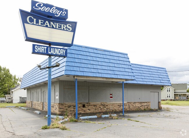
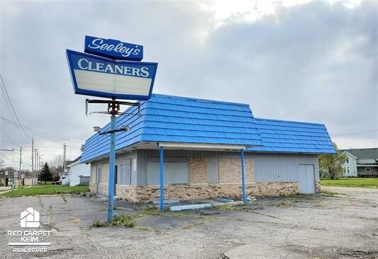
Property Record
2002 Fenton Rd, Flint, MI 48507
NEARBY LISTINGS FOR SALE OR LEASE
Property Detail
2002 Fenton Rd
Detroit
Supervisor's Plat Of Fenton Heights
Flint, MI
SUPERVISOR'S PLAT OF FENTON HEIGHTS LOT 8 SPLIT ON 09/04/2024 FROM 40-24-231-024;
40-24-231-030
Genesee
Commercialnec
Michigan
0
8
2025
0.24 AC
013500
Flint
2,340 SF
DEMOGRAPHICS near 2002 Fenton Rd
1 Mile
3 Mile
5 Mile
2024 Total Population
8,079
78,994
151,573
2029 Population
8,215
79,580
152,327
Pop Growth 2024-2029
+ 1.68%
+ 0.74%
+ 0.50%
Average Age
38
38
39
2024 Total Households
3,262
32,731
63,668
HH Growth 2024-2029
+ 1.99%
+ 0.65%
+ 0.43%
Median Household Inc
$31,615
$36,378
$38,623
Avg Household Size
2.20
2.30
2.30
2024 Avg HH Vehicles
1.00
1.00
1.00
Median Home Value
$65,515
$69,344
$79,520
Median Year Built
1952
1957
1960
Nearby Places
Map Layers
Map Styles
 Street
 Aerial
- Restaurants
- Banks
- Shops
- Fitness
- Groceries
PUBLIC TRANSPORTATION
COMMUTER RAIL
Flint Amtrak Station (Blue Water - Amtrak)
DRIVE
WALK
Distance
Flint Amtrak Station (Blue Water - Amtrak)
6 min
2.9 mi
AIRPORT
Bishop International
DRIVE
WALK
Distance
Bishop International
20 min
8.2 mi
Freight Ports
Port of Toledo
DRIVE
WALK
Distance
Port of Toledo
135 min
114.0 mi
SALE & LEASE HISTORY
LISTING DATE
SALE/LEASE

Sep 25, 2016
For Lease
Sep 23, 2016
For Sale
Dec 05, 2019
For Sale
Nearby Properties
Address
Land Use
TOTAL SIZE
Lot Size
Zoning
Address
Land Use
TOTAL SIZE
Lot Size
Zoning
381,509 SF
371.45 AC
PC
Address
Land Use
TOTAL SIZE
Lot Size
Zoning
Address
Land Use
TOTAL SIZE
Lot Size
Zoning
911,140 SF
Address
Land Use
TOTAL SIZE
Lot Size
Zoning
54,651 SF
3.06 AC
Address
Land Use
TOTAL SIZE
Lot Size
Zoning
130,291 SF
Address
Land Use
TOTAL SIZE
Lot Size
Zoning
112,232 SF
196 AC
Address
Land Use
TOTAL SIZE
Lot Size
Zoning
144,896 SF
0.23 AC
DC
Address
Land Use
TOTAL SIZE
Lot Size
Zoning
115,556 SF
2.50 AC
DE
Address
Land Use
TOTAL SIZE
Lot Size
Zoning
59,232 SF
3.65 AC
Address
Land Use
TOTAL SIZE
Lot Size
Zoning
100,000 SF
Address
Land Use
TOTAL SIZE
Lot Size
Zoning
100,750 SF
Address
Land Use
TOTAL SIZE
Lot Size
Zoning
329,849 SF
21.20 AC
CE
Address
Land Use
TOTAL SIZE
Lot Size
Zoning
247,555 SF
198 AC
Address
Land Use
TOTAL SIZE
Lot Size
Zoning
68,571 SF
0.81 AC
DC
Address
Land Use
TOTAL SIZE
Lot Size
Zoning
246,759 SF
19.03 AC
CC
Address
Land Use
TOTAL SIZE
Lot Size
Zoning
48,557 SF
2.99 AC
Address
Land Use
TOTAL SIZE
Lot Size
Zoning
156,250 SF
Address
Land Use
TOTAL SIZE
Lot Size
Zoning
364,289 SF
24.80 AC
GN-1
Address
Land Use
TOTAL SIZE
Lot Size
Zoning
236,340 SF
25.17 AC
CE
Address
Land Use
TOTAL SIZE
Lot Size
Zoning
11.22 AC
RM
Address
Land Use
TOTAL SIZE
Lot Size
Zoning
10,212 SF
2.60 AC
UC
Address
Land Use
TOTAL SIZE
Lot Size
Zoning
94,280 SF
48.79 AC
Address
Land Use
TOTAL SIZE
Lot Size
Zoning
2,321 SF
18.59 AC
M-1
Address
Land Use
TOTAL SIZE
Lot Size
Zoning
6,051 SF
3.82 AC
Address
Land Use
TOTAL SIZE
Lot Size
Zoning
85,697 SF
0.30 AC
DC
Address
Land Use
TOTAL SIZE
Lot Size
Zoning
209,058 SF
9.02 AC
Address
Land Use
TOTAL SIZE
Lot Size
Zoning
25,496 SF
5.33 AC
Address
Land Use
TOTAL SIZE
Lot Size
Zoning
131,641 SF
136 AC
Address
Land Use
TOTAL SIZE
Lot Size
Zoning
403,803 SF
252 AC
Address
Land Use
TOTAL SIZE
Lot Size
Zoning
79,828 SF
6.48 AC
The World's #1 Commercial Real Estate Marketplace
Connect with us
© 2025 CoStar Group
The information above has been obtained from sources believed reliable. While we do not doubt its accuracy we have not verified it and make no guarantee, warranty or representation about it. It is your responsibility to independently confirm its accuracy and completeness. Any projections, opinions, assumptions, or estimates used are for example only and do not represent the current or future performance of the property. The value of this transaction to you depends on tax and other factors which should be evaluated by your tax, financial, and legal advisors. You and your advisors should conduct a careful, independent investigation of the property to determine to your satisfaction the suitability of the property for your needs.