Property Record
2002 Graves Ct, Dundalk, MD 21222
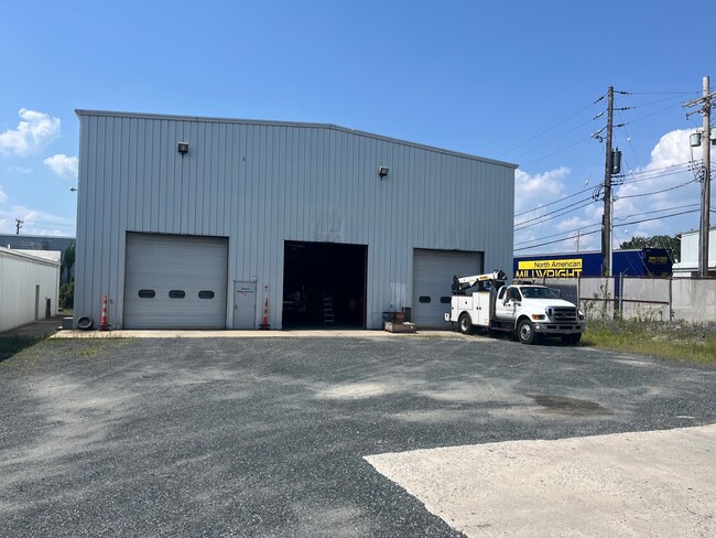


Property Detail
2002 Graves Ct
12-1211090190
.868 AC
Warehouse
Baltimore
ML
Maryland
B and X Area of moderate flood hazard, usually the area between the limits of the 100-year and 500-year floods.
0.86 AC
2024
Baltimore County East
2025
Baltimore
420200
Baltimore-Columbia-Towson, MD
11,037 SF
NEARBY LISTINGS FOR SALE OR LEASE
DEMOGRAPHICS near 2002 Graves Ct
1 mile
3 mile
5 mile
2025 Total Population
20,438
76,874
166,237
2030 Population
20,470
76,893
165,304
Pop Growth 2025-2030
+ 0.16%
+ 0.02%
(0.56%)
Average Age
39
39
39
2025 Total Households
7,720
28,567
65,300
HH Growth 2025-2030
+ 0.17%
(0.01%)
(0.62%)
Median Household Inc
$66,385
$60,723
$69,027
Avg Household Size
2.60
2.60
2.50
2025 Avg HH Vehicles
2.00
2.00
2.00
Median Home Value
$219,844
$211,381
$252,445
Median Year Built
1954
1954
1953
Nearby Places
Map Layers
Map Styles
 Street
 Aerial
Transit
 Traffic
 Biking
Places
Listings with unknown addresses are not visible on the map
- Restaurants
- Banks
- Shops
- Fitness
- Groceries
Nearby Properties
Address
Land Use
TOTAL SIZE
Lot Size
Zoning
Address
Land Use
TOTAL SIZE
Lot Size
Zoning
1,015,550 SF
64.95 AC
I-2
Address
Land Use
TOTAL SIZE
Lot Size
Zoning
979,200 SF
49.24 AC
Address
Land Use
TOTAL SIZE
Lot Size
Zoning
859,500 SF
64.32 AC
MH-IM
Address
Land Use
TOTAL SIZE
Lot Size
Zoning
1,282,700 SF
66.23 AC
Address
Land Use
TOTAL SIZE
Lot Size
Zoning
263 AC
0M030
Address
Land Use
TOTAL SIZE
Lot Size
Zoning
347,000 SF
42.73 AC
DR
Address
Land Use
TOTAL SIZE
Lot Size
Zoning
161,190 SF
115.02 AC
Address
Land Use
TOTAL SIZE
Lot Size
Zoning
698,880 SF
60.82 AC
Address
Land Use
TOTAL SIZE
Lot Size
Zoning
519,489 SF
45.05 AC
Address
Land Use
TOTAL SIZE
Lot Size
Zoning
603,980 SF
30.68 AC
Address
Land Use
TOTAL SIZE
Lot Size
Zoning
291,062 SF
47.39 AC
Address
Land Use
TOTAL SIZE
Lot Size
Zoning
619,700 SF
34.98 AC
I-2
Address
Land Use
TOTAL SIZE
Lot Size
Zoning
Address
Land Use
TOTAL SIZE
Lot Size
Zoning
735,681 SF
44.98 AC
Address
Land Use
TOTAL SIZE
Lot Size
Zoning
449,920 SF
26.42 AC
Address
Land Use
TOTAL SIZE
Lot Size
Zoning
278,006 SF
49.85 AC
DR
Address
Land Use
TOTAL SIZE
Lot Size
Zoning
413,345 SF
46.90 AC
I-2
Address
Land Use
TOTAL SIZE
Lot Size
Zoning
401,280 SF
25.38 AC
Address
Land Use
TOTAL SIZE
Lot Size
Zoning
33.65 AC
DR16
Address
Land Use
TOTAL SIZE
Lot Size
Zoning
72,600 SF
35.27 AC
Address
Land Use
TOTAL SIZE
Lot Size
Zoning
399,600 SF
21.59 AC
Address
Land Use
TOTAL SIZE
Lot Size
Zoning
135,548 SF
13 AC
DR5.5
Address
Land Use
TOTAL SIZE
Lot Size
Zoning
279,062 SF
13.40 AC
I-2
Address
Land Use
TOTAL SIZE
Lot Size
Zoning
346,408 SF
18.50 AC
I-2
Address
Land Use
TOTAL SIZE
Lot Size
Zoning
139.18 AC
MI
Address
Land Use
TOTAL SIZE
Lot Size
Zoning
97,784 SF
1.35 AC
DR10.
Address
Land Use
TOTAL SIZE
Lot Size
Zoning
342,500 SF
52.40 AC
I-2
Address
Land Use
TOTAL SIZE
Lot Size
Zoning
666,800 SF
17.50 AC
OIC
Address
Land Use
TOTAL SIZE
Lot Size
Zoning
213,997 SF
45.22 AC
DR
Address
Land Use
TOTAL SIZE
Lot Size
Zoning
75.99 AC
The World's #1 Commercial Real Estate Marketplace
Connect with us
© 2026 CoStar Group
The information above has been obtained from sources believed reliable. While we do not doubt its accuracy we have not verified it and make no guarantee, warranty or representation about it. It is your responsibility to independently confirm its accuracy and completeness. Any projections, opinions, assumptions, or estimates used are for example only and do not represent the current or future performance of the property. The value of this transaction to you depends on tax and other factors which should be evaluated by your tax, financial, and legal advisors. You and your advisors should conduct a careful, independent investigation of the property to determine to your satisfaction the suitability of the property for your needs.