Property Record
2002 Jim Johnson Rd, Concord, NC 28027

Save to a Folder
{{folder.Name}}
{{folder.ListingIds.length}} Properties
{{folder.ListingIds.length}} Property
Create a New Folder
Property Detail
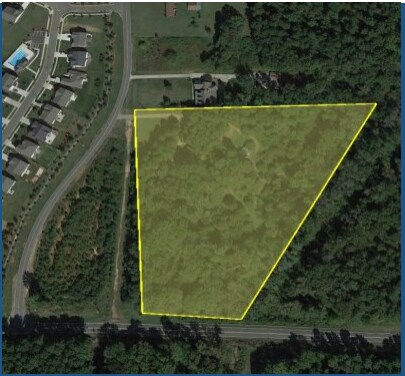
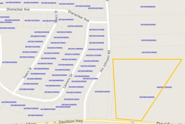
2002 Jim Johnson Rd
4672-90-4616-0000
INTERSEC NC HWY 73 & JIM JOHNSON RD
Commercialnec
CABARRUS
GC
North Carolina
AE The base floodplain where base flood elevations are provided. AE Zones are now used on new format FIRMs instead of A1-A30 Zones.
2.30 AC
2025
Cabarrus County
2025
Charlotte
042503
Charlotte-Concord-Gastonia, NC-SC
NEARBY LISTINGS FOR SALE OR LEASE
-
-
View all Concord listings for sale on LoopNet.com
DEMOGRAPHICS near 2002 Jim Johnson Rd
1 mile
3 mile
5 mile
2025 Total Population
8,596
29,940
78,524
2030 Population
9,235
32,240
84,812
Pop Growth 2025-2030
+ 7.43%
+ 7.68%
+ 8.01%
Average Age
34
36
38
2025 Total Households
2,565
9,370
27,504
HH Growth 2025-2030
+ 7.56%
+ 7.82%
+ 8.14%
Median Household Inc
$130,551
$151,978
$130,695
Avg Household Size
3.30
3.20
2.80
2025 Avg HH Vehicles
2.00
2.00
2.00
Median Home Value
$453,532
$549,232
$522,472
Median Year Built
2009
2009
2006
Nearby Places
Map Layers
Map Styles
 Street
 Aerial
Layers
 Traffic
 Biking
Places
Listings with unknown addresses are not visible on the map
- Restaurants
- Banks
- Shops
- Fitness
- Groceries
PUBLIC TRANSPORTATION
AIRPORT
Concord-Padgett Regional
Drive
Walk
Distance
Concord-Padgett Regional
12 min
6.4 mi
Charlotte/Douglas International
Drive
Walk
Distance
Charlotte/Douglas International
42 min
29.8 mi
Freight Ports
Port of Wilmington
Drive
Walk
Distance
Port of Wilmington
265 min
210.1 mi
Nearby Properties
Address
Land Use
TOTAL SIZE
Lot Size
Zoning
Address
Land Use
TOTAL SIZE
Lot Size
Zoning
146,501 SF
78.92 AC
O-I
Address
Land Use
TOTAL SIZE
Lot Size
Zoning
1,866.27 AC
AO
Address
Land Use
TOTAL SIZE
Lot Size
Zoning
30,682 SF
24.33 AC
LDR
Address
Land Use
TOTAL SIZE
Lot Size
Zoning
140,605 SF
33.96 AC
R
Address
Land Use
TOTAL SIZE
Lot Size
Zoning
26,134 SF
98.70 AC
GC
Address
Land Use
TOTAL SIZE
Lot Size
Zoning
77,612 SF
21.10 AC
NE
Address
Land Use
TOTAL SIZE
Lot Size
Zoning
92,838 SF
26.04 AC
O-I
Address
Land Use
TOTAL SIZE
Lot Size
Zoning
24,568 SF
81.59 AC
RM-1
Address
Land Use
TOTAL SIZE
Lot Size
Zoning
190,682 SF
27.93 AC
CUI-1
Address
Land Use
TOTAL SIZE
Lot Size
Zoning
165,015 SF
19.02 AC
I-1
Address
Land Use
TOTAL SIZE
Lot Size
Zoning
12,548 SF
5.32 AC
PUD
Address
Land Use
TOTAL SIZE
Lot Size
Zoning
52,843 SF
9.76 AC
CUC-2
Address
Land Use
TOTAL SIZE
Lot Size
Zoning
24,336 SF
6.78 AC
C-2
Address
Land Use
TOTAL SIZE
Lot Size
Zoning
15,900 SF
7.63 AC
GC
Address
Land Use
TOTAL SIZE
Lot Size
Zoning
80,085 SF
14.48 AC
CUI-1
Address
Land Use
TOTAL SIZE
Lot Size
Zoning
27,416 SF
2.06 AC
GC
Address
Land Use
TOTAL SIZE
Lot Size
Zoning
45,082 SF
3.49 AC
C-2-CD
Address
Land Use
TOTAL SIZE
Lot Size
Zoning
17,515 SF
2.73 AC
C-2
Address
Land Use
TOTAL SIZE
Lot Size
Zoning
14,810 SF
2.47 AC
PUD
Address
Land Use
TOTAL SIZE
Lot Size
Zoning
15,021 SF
1.44 AC
GC
Address
Land Use
TOTAL SIZE
Lot Size
Zoning
13,950 SF
5.79 AC
CUI-1
Address
Land Use
TOTAL SIZE
Lot Size
Zoning
15,622 SF
2.60 AC
CD-OI
Address
Land Use
TOTAL SIZE
Lot Size
Zoning
37.84 AC
SP(CD)
Address
Land Use
TOTAL SIZE
Lot Size
Zoning
8,408 SF
1.96 AC
C-2
Address
Land Use
TOTAL SIZE
Lot Size
Zoning
8,750 SF
1.67 AC
CUC-2
Address
Land Use
TOTAL SIZE
Lot Size
Zoning
13.10 AC
PUD
Address
Land Use
TOTAL SIZE
Lot Size
Zoning
14.63 AC
C-2-CD
Address
Land Use
TOTAL SIZE
Lot Size
Zoning
13.08 AC
PUD
Address
Land Use
TOTAL SIZE
Lot Size
Zoning
8,010 SF
1.11 AC
GC
Address
Land Use
TOTAL SIZE
Lot Size
Zoning
4,096 SF
1.33 AC
GC
The World's #1 Commercial Real Estate Marketplace
Connect with us
© 2026 CoStar Group
The information above has been obtained from sources believed reliable. While we do not doubt its accuracy we have not verified it and make no guarantee, warranty or representation about it. It is your responsibility to independently confirm its accuracy and completeness. Any projections, opinions, assumptions, or estimates used are for example only and do not represent the current or future performance of the property. The value of this transaction to you depends on tax and other factors which should be evaluated by your tax, financial, and legal advisors. You and your advisors should conduct a careful, independent investigation of the property to determine to your satisfaction the suitability of the property for your needs.