Property Record
2002 Marshall St, Manitowoc, WI 54220
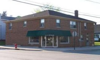

Property Detail
2002 Marshall St
Manitowoc, WI
LOT 19 BLK 260
052-000-260-190.00
Manitowoc
Commercialnec
Wisconsin
B and X Area of moderate flood hazard, usually the area between the limits of the 100-year and 500-year floods.
19
2024
0.12 AC
2024
Wisconsin South Area
000500
Other Market Areas
4,284 SF
NEARBY LISTINGS FOR SALE OR LEASE
DEMOGRAPHICS near 2002 Marshall St
1 mile
3 mile
5 mile
2025 Total Population
12,281
33,140
38,024
2030 Population
12,247
33,041
37,953
Pop Growth 2025-2030
(0.28%)
(0.30%)
(0.19%)
Average Age
40
43
44
2025 Total Households
5,325
14,575
16,676
HH Growth 2025-2030
(0.26%)
(0.32%)
(0.19%)
Median Household Inc
$53,651
$60,500
$62,463
Avg Household Size
2.20
2.20
2.20
2025 Avg HH Vehicles
2.00
2.00
2.00
Median Home Value
$138,646
$168,517
$176,886
Median Year Built
1948
1957
1961
Nearby Places
Map Layers
Map Styles
 Street
 Aerial
Layers
 Traffic
 Biking
Places
Listings with unknown addresses are not visible on the map
- Restaurants
- Banks
- Shops
- Fitness
- Groceries
PUBLIC TRANSPORTATION
AIRPORT
Green Bay/Austin Straubel International
Drive
Walk
Distance
Green Bay/Austin Straubel International
54 min
43.5 mi
Nearby Properties
Address
Land Use
TOTAL SIZE
Lot Size
Zoning
Address
Land Use
TOTAL SIZE
Lot Size
Zoning
140,000 SF
5.63 AC
Address
Land Use
TOTAL SIZE
Lot Size
Zoning
36.16 AC
Address
Land Use
TOTAL SIZE
Lot Size
Zoning
74,004 SF
12.64 AC
Address
Land Use
TOTAL SIZE
Lot Size
Zoning
202,432 SF
20.27 AC
Address
Land Use
TOTAL SIZE
Lot Size
Zoning
49.62 AC
Address
Land Use
TOTAL SIZE
Lot Size
Zoning
176,600 SF
18.79 AC
Address
Land Use
TOTAL SIZE
Lot Size
Zoning
45,901 SF
9.26 AC
Address
Land Use
TOTAL SIZE
Lot Size
Zoning
12.50 AC
Address
Land Use
TOTAL SIZE
Lot Size
Zoning
15,775 SF
1.64 AC
Address
Land Use
TOTAL SIZE
Lot Size
Zoning
66,328 SF
6.09 AC
Address
Land Use
TOTAL SIZE
Lot Size
Zoning
160,600 SF
20.73 AC
Address
Land Use
TOTAL SIZE
Lot Size
Zoning
15.62 AC
Address
Land Use
TOTAL SIZE
Lot Size
Zoning
21.54 AC
Address
Land Use
TOTAL SIZE
Lot Size
Zoning
76,362 SF
7.83 AC
Address
Land Use
TOTAL SIZE
Lot Size
Zoning
150,045 SF
10.42 AC
Address
Land Use
TOTAL SIZE
Lot Size
Zoning
29.89 AC
Address
Land Use
TOTAL SIZE
Lot Size
Zoning
187,990 SF
12.45 AC
Address
Land Use
TOTAL SIZE
Lot Size
Zoning
677,161 SF
9.15 AC
Address
Land Use
TOTAL SIZE
Lot Size
Zoning
48,828 SF
0.65 AC
Address
Land Use
TOTAL SIZE
Lot Size
Zoning
21.54 AC
Address
Land Use
TOTAL SIZE
Lot Size
Zoning
22.60 AC
Address
Land Use
TOTAL SIZE
Lot Size
Zoning
18,483 SF
3.12 AC
Address
Land Use
TOTAL SIZE
Lot Size
Zoning
7.08 AC
Address
Land Use
TOTAL SIZE
Lot Size
Zoning
17.41 AC
Address
Land Use
TOTAL SIZE
Lot Size
Zoning
25,460 SF
5.06 AC
Address
Land Use
TOTAL SIZE
Lot Size
Zoning
45,708 SF
5.66 AC
Address
Land Use
TOTAL SIZE
Lot Size
Zoning
59,680 SF
6.40 AC
Address
Land Use
TOTAL SIZE
Lot Size
Zoning
64,206 SF
3.76 AC
Address
Land Use
TOTAL SIZE
Lot Size
Zoning
107,800 SF
11.92 AC
Address
Land Use
TOTAL SIZE
Lot Size
Zoning
10.25 AC
The World's #1 Commercial Real Estate Marketplace
Connect with us
© 2026 CoStar Group
The information above has been obtained from sources believed reliable. While we do not doubt its accuracy we have not verified it and make no guarantee, warranty or representation about it. It is your responsibility to independently confirm its accuracy and completeness. Any projections, opinions, assumptions, or estimates used are for example only and do not represent the current or future performance of the property. The value of this transaction to you depends on tax and other factors which should be evaluated by your tax, financial, and legal advisors. You and your advisors should conduct a careful, independent investigation of the property to determine to your satisfaction the suitability of the property for your needs.