Property Record
2010 Missouri Ave, Omaha, NE 68107
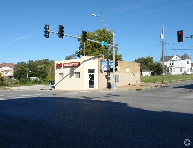

This Property Is For Sale
NEARBY LISTINGS FOR SALE OR LEASE
Property Detail
2010 Missouri Ave
Omaha-Council Bluffs, NE-IA
South Omaha City Lots
1618-0000-04
SOUTH OMAHA CITY LOTS LOT 4 BLOCK 123 W 60 FT LT 3 & -EX ST-
Commercialnec
Douglas
X
Nebraska
31153C0080G
4,3
2024
0.09 AC
2025
Southeast Omaha
002600
Omaha/Council Bluffs
DEMOGRAPHICS near 2010 Missouri Ave
1 Mile
3 Mile
5 Mile
2024 Total Population
12,874
96,419
225,267
2029 Population
13,020
98,465
231,300
Pop Growth 2024-2029
+ 1.13%
+ 2.12%
+ 2.68%
Average Age
33
35
37
2024 Total Households
3,967
35,212
90,138
HH Growth 2024-2029
+ 1.11%
+ 2.37%
+ 2.85%
Median Household Inc
$50,491
$52,816
$55,383
Avg Household Size
3.10
2.60
2.30
2024 Avg HH Vehicles
2.00
2.00
2.00
Median Home Value
$118,267
$153,489
$170,857
Median Year Built
1947
1953
1960
Nearby Places
Map Layers
Map Styles
 Street
 Aerial
- Restaurants
- Banks
- Shops
- Fitness
- Groceries
PUBLIC TRANSPORTATION
COMMUTER RAIL
Omaha Amtrak Station (California Zephyr - Amtrak)
DRIVE
WALK
Distance
Omaha Amtrak Station (California Zephyr - Amtrak)
6 min
3.2 mi
Omaha Amtrak Station (California Zephyr - Amtrak)
DRIVE
WALK
Distance
Omaha Amtrak Station (California Zephyr - Amtrak)
7 min
3.3 mi
AIRPORT
Eppley Airfield
DRIVE
WALK
Distance
Eppley Airfield
16 min
8.5 mi
Freight Ports
Tulsa Port Of Catoosa
DRIVE
WALK
Distance
Tulsa Port Of Catoosa
458 min
415.4 mi
Nearby Properties
Address
Land Use
TOTAL SIZE
Lot Size
Zoning
Address
Land Use
TOTAL SIZE
Lot Size
Zoning
36.26 AC
P-C
Address
Land Use
TOTAL SIZE
Lot Size
Zoning
346,816 SF
0.80 AC
Address
Land Use
TOTAL SIZE
Lot Size
Zoning
318,392 SF
7.77 AC
Address
Land Use
TOTAL SIZE
Lot Size
Zoning
319,440 SF
3.05 AC
Address
Land Use
TOTAL SIZE
Lot Size
Zoning
27.38 AC
I-2
Address
Land Use
TOTAL SIZE
Lot Size
Zoning
149,737 SF
1.93 AC
Address
Land Use
TOTAL SIZE
Lot Size
Zoning
198,447 SF
1.36 AC
Address
Land Use
TOTAL SIZE
Lot Size
Zoning
15.96 AC
I-2
Address
Land Use
TOTAL SIZE
Lot Size
Zoning
189,690 SF
0.57 AC
Address
Land Use
TOTAL SIZE
Lot Size
Zoning
105,193 SF
1.52 AC
Address
Land Use
TOTAL SIZE
Lot Size
Zoning
174,726 SF
4.33 AC
Address
Land Use
TOTAL SIZE
Lot Size
Zoning
12.71 AC
Address
Land Use
TOTAL SIZE
Lot Size
Zoning
154,493 SF
0.80 AC
Address
Land Use
TOTAL SIZE
Lot Size
Zoning
148,789 SF
2.52 AC
Address
Land Use
TOTAL SIZE
Lot Size
Zoning
1,850 SF
8.14 AC
Address
Land Use
TOTAL SIZE
Lot Size
Zoning
168,155 SF
0.30 AC
CBD
Address
Land Use
TOTAL SIZE
Lot Size
Zoning
143,368 SF
5.31 AC
Address
Land Use
TOTAL SIZE
Lot Size
Zoning
191,768 SF
3.08 AC
Address
Land Use
TOTAL SIZE
Lot Size
Zoning
32.10 AC
I-2
Address
Land Use
TOTAL SIZE
Lot Size
Zoning
23.52 AC
I-2
Address
Land Use
TOTAL SIZE
Lot Size
Zoning
156,582 SF
0.92 AC
Address
Land Use
TOTAL SIZE
Lot Size
Zoning
225,975 SF
1.31 AC
Address
Land Use
TOTAL SIZE
Lot Size
Zoning
193,967 SF
7.27 AC
Address
Land Use
TOTAL SIZE
Lot Size
Zoning
3.67 AC
P-C
Address
Land Use
TOTAL SIZE
Lot Size
Zoning
114,130 SF
1.06 AC
Address
Land Use
TOTAL SIZE
Lot Size
Zoning
236,067 SF
10.12 AC
HI
Address
Land Use
TOTAL SIZE
Lot Size
Zoning
126,669 SF
0.61 AC
Address
Land Use
TOTAL SIZE
Lot Size
Zoning
33,713 SF
14.39 AC
Address
Land Use
TOTAL SIZE
Lot Size
Zoning
108,496 SF
0.60 AC
Address
Land Use
TOTAL SIZE
Lot Size
Zoning
143,892 SF
1.09 AC
The World's #1 Commercial Real Estate Marketplace
Connect with us
© 2025 CoStar Group
The information above has been obtained from sources believed reliable. While we do not doubt its accuracy we have not verified it and make no guarantee, warranty or representation about it. It is your responsibility to independently confirm its accuracy and completeness. Any projections, opinions, assumptions, or estimates used are for example only and do not represent the current or future performance of the property. The value of this transaction to you depends on tax and other factors which should be evaluated by your tax, financial, and legal advisors. You and your advisors should conduct a careful, independent investigation of the property to determine to your satisfaction the suitability of the property for your needs.