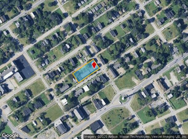
Property Record
2001 E Obear Ave, Saint Louis, MO 63107
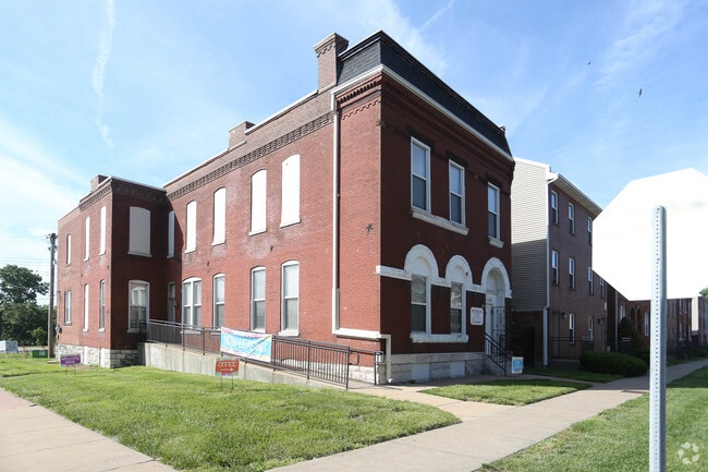
This Property Is For Sale
NEARBY LISTINGS FOR SALE OR LEASE
Property Detail
2001 E Obear Ave
St. Louis, MO-IL
Bryan Est Addn
2477-00-0185-0
C B 2477 OBEAR AV 253 FT X 110 FT 2ND W J BRYAN EST ADDN BLK 45 LOTS 11 THRU 15
Multifamilydwelling
St. Louis City
X
Missouri
2903850062C
11-15
2024
0.64 AC
2025
College Hill
109700
St. Louis
23,226 SF
DEMOGRAPHICS near 2001 E Obear Ave
1 Mile
3 Mile
5 Mile
2024 Total Population
8,853
75,296
220,181
2029 Population
8,774
73,545
215,010
Pop Growth 2024-2029
(0.89%)
(2.33%)
(2.35%)
Average Age
41
40
39
2024 Total Households
3,711
33,967
101,883
HH Growth 2024-2029
(0.67%)
(2.48%)
(2.64%)
Median Household Inc
$30,849
$34,093
$42,026
Avg Household Size
2.30
2.00
2.00
2024 Avg HH Vehicles
1.00
1.00
1.00
Median Home Value
$87,901
$86,672
$103,673
Median Year Built
1946
1948
1948
Nearby Places
- Restaurants
- Banks
- Shops
- Fitness
- Groceries
PUBLIC TRANSPORTATION
COMMUTER RAIL
Convention Center (Lambert Airport Shiloh-Scott - St. Louis MetroLink (MetroLink), Shrewsbury-Lansdowne I-44 Emerson Park - St. Louis MetroLink (MetroLink))
DRIVE
WALK
Distance
Convention Center (Lambert Airport Shiloh-Scott - St. Louis MetroLink (MetroLink), Shrewsbury-Lansdowne I-44 Emerson Park - St. Louis MetroLink (MetroLink))
6 min
3.7 mi
Union Station (Lambert Airport Shiloh-Scott - St. Louis MetroLink (MetroLink), Shrewsbury-Lansdowne I-44 Emerson Park - St. Louis MetroLink (MetroLink))
DRIVE
WALK
Distance
Union Station (Lambert Airport Shiloh-Scott - St. Louis MetroLink (MetroLink), Shrewsbury-Lansdowne I-44 Emerson Park - St. Louis MetroLink (MetroLink))
7 min
4.0 mi
AIRPORT
St Louis Lambert International
DRIVE
WALK
Distance
St Louis Lambert International
17 min
10.8 mi
Scott AFB/Midamerica St Louis
DRIVE
WALK
Distance
Scott AFB/Midamerica St Louis
41 min
27.6 mi
Freight Ports
Port Milwaukee
DRIVE
WALK
Distance
Port Milwaukee
420 min
371.8 mi
Nearby Properties
Address
Land Use
TOTAL SIZE
Lot Size
Zoning
Address
Land Use
TOTAL SIZE
Lot Size
Zoning
467,000 SF
11.19 AC
I
Address
Land Use
TOTAL SIZE
Lot Size
Zoning
661,472 SF
7.29 AC
L
Address
Land Use
TOTAL SIZE
Lot Size
Zoning
1.72 AC
I
Address
Land Use
TOTAL SIZE
Lot Size
Zoning
472,328 SF
19.85 AC
I
Address
Land Use
TOTAL SIZE
Lot Size
Zoning
7.38 AC
I
Address
Land Use
TOTAL SIZE
Lot Size
Zoning
1,089,750 SF
8.43 AC
I
Address
Land Use
TOTAL SIZE
Lot Size
Zoning
Address
Land Use
TOTAL SIZE
Lot Size
Zoning
702,704 SF
2.10 AC
I
Address
Land Use
TOTAL SIZE
Lot Size
Zoning
190,000 SF
2.71 AC
I
Address
Land Use
TOTAL SIZE
Lot Size
Zoning
8.54 AC
H
Address
Land Use
TOTAL SIZE
Lot Size
Zoning
15.11 AC
I
Address
Land Use
TOTAL SIZE
Lot Size
Zoning
5.79 AC
I
Address
Land Use
TOTAL SIZE
Lot Size
Zoning
5.29 AC
I
Address
Land Use
TOTAL SIZE
Lot Size
Zoning
98,308 SF
97.62 AC
H
Address
Land Use
TOTAL SIZE
Lot Size
Zoning
54.74 AC
K
Address
Land Use
TOTAL SIZE
Lot Size
Zoning
269,300 SF
4.92 AC
H
Address
Land Use
TOTAL SIZE
Lot Size
Zoning
137,692 SF
0.34 AC
I
Address
Land Use
TOTAL SIZE
Lot Size
Zoning
Address
Land Use
TOTAL SIZE
Lot Size
Zoning
18.56 AC
H
Address
Land Use
TOTAL SIZE
Lot Size
Zoning
46.18 AC
A
Address
Land Use
TOTAL SIZE
Lot Size
Zoning
718,644 SF
3.53 AC
I
Address
Land Use
TOTAL SIZE
Lot Size
Zoning
573,157 SF
1.53 AC
I
Address
Land Use
TOTAL SIZE
Lot Size
Zoning
298,990 SF
6.62 AC
I
Address
Land Use
TOTAL SIZE
Lot Size
Zoning
194,092 SF
1.57 AC
I
Address
Land Use
TOTAL SIZE
Lot Size
Zoning
136,896 SF
2.22 AC
I
Address
Land Use
TOTAL SIZE
Lot Size
Zoning
406,744 SF
1.95 AC
I
Address
Land Use
TOTAL SIZE
Lot Size
Zoning
739,544 SF
5.59 AC
H
Address
Land Use
TOTAL SIZE
Lot Size
Zoning
2.18 AC
I
Address
Land Use
TOTAL SIZE
Lot Size
Zoning
2.18 AC
I
Address
Land Use
TOTAL SIZE
Lot Size
Zoning
1,124,252 SF
2.04 AC
I
The World's #1 Commercial Real Estate Marketplace
Connect with us
© 2025 CoStar Group
The information above has been obtained from sources believed reliable. While we do not doubt its accuracy we have not verified it and make no guarantee, warranty or representation about it. It is your responsibility to independently confirm its accuracy and completeness. Any projections, opinions, assumptions, or estimates used are for example only and do not represent the current or future performance of the property. The value of this transaction to you depends on tax and other factors which should be evaluated by your tax, financial, and legal advisors. You and your advisors should conduct a careful, independent investigation of the property to determine to your satisfaction the suitability of the property for your needs.