Property Record
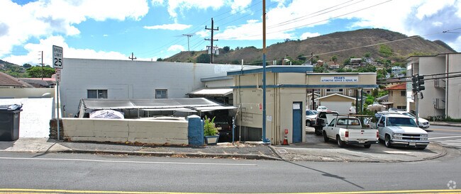
2007 Pacific Heights Rd, Honolulu, HI 96813


Property Detail
2007 Pacific Heights Rd
1-2-2-011-032-0000
LOT G POR LOT 6 & 7 POR RPGR 2180 PAUOA VALLEY LOTS FP 193 3,784 SF DES SUBJ/E FOR SEWER PIPE LINE(S)
Commercialnec
HONOLULU
B-1
Hawaii
B and X Area of moderate flood hazard, usually the area between the limits of the 100-year and 500-year floods.
g,6,7
2024
0.09 AC
2025
Honolulu
004102
Hawaii
1,386 SF
Urban Honolulu, HI
NEARBY LISTINGS FOR SALE OR LEASE
DEMOGRAPHICS near 2007 Pacific Heights Rd
1 mile
3 mile
5 mile
2025 Total Population
49,380
239,366
345,690
2030 Population
49,355
240,672
347,810
Pop Growth 2025-2030
(0.05%)
+ 0.55%
+ 0.61%
Average Age
45
44
44
2025 Total Households
20,062
97,502
138,397
HH Growth 2025-2030
(0.18%)
+ 0.82%
+ 0.86%
Median Household Inc
$76,832
$81,347
$86,683
Avg Household Size
2.30
2.30
2.30
2025 Avg HH Vehicles
1.00
1.00
1.00
Median Home Value
$740,524
$787,003
$850,083
Median Year Built
1973
1974
1973
Nearby Places
Map Layers
Map Styles
 Street
 Aerial
Layers
 Traffic
 Biking
Places
Listings with unknown addresses are not visible on the map
- Restaurants
- Banks
- Shops
- Fitness
- Groceries
PUBLIC TRANSPORTATION
AIRPORT
Daniel K Inouye International
Drive
Walk
Distance
Daniel K Inouye International
12 min
6.0 mi
Freight Ports
Honolulu Harbor, Oahu
Drive
Walk
Distance
Honolulu Harbor, Oahu
14 min
5.9 mi
Nearby Properties
Address
Land Use
TOTAL SIZE
Lot Size
Zoning
Address
Land Use
TOTAL SIZE
Lot Size
Zoning
7,944,732 SF
34.93 AC
BMX-3
Address
Land Use
TOTAL SIZE
Lot Size
Zoning
119.90 AC
U/X7/60
Address
Land Use
TOTAL SIZE
Lot Size
Zoning
492,607 SF
9.06 AC
ResMix
Address
Land Use
TOTAL SIZE
Lot Size
Zoning
1,675.63 AC
C/61/60
Address
Land Use
TOTAL SIZE
Lot Size
Zoning
13,088 SF
75.21 AC
P-2
Address
Land Use
TOTAL SIZE
Lot Size
Zoning
1,100,000 SF
9.65 AC
BMX-3
Address
Land Use
TOTAL SIZE
Lot Size
Zoning
55.93 AC
WI
Address
Land Use
TOTAL SIZE
Lot Size
Zoning
1,153,381 SF
425.42 AC
R-5
Address
Land Use
TOTAL SIZE
Lot Size
Zoning
45.65 AC
Kak
Address
Land Use
TOTAL SIZE
Lot Size
Zoning
42.67 AC
P-2
Address
Land Use
TOTAL SIZE
Lot Size
Zoning
1,599,500 SF
7.27 AC
BMX-3
Address
Land Use
TOTAL SIZE
Lot Size
Zoning
2.32 AC
Kak
Address
Land Use
TOTAL SIZE
Lot Size
Zoning
254,832 SF
2.92 AC
BMX-4
Address
Land Use
TOTAL SIZE
Lot Size
Zoning
64,300 SF
0.77 AC
ResMix
Address
Land Use
TOTAL SIZE
Lot Size
Zoning
104,386 SF
1.04 AC
ResMix
Address
Land Use
TOTAL SIZE
Lot Size
Zoning
172,305 SF
2.54 AC
ResMix
Address
Land Use
TOTAL SIZE
Lot Size
Zoning
1.13 AC
ResMix
Address
Land Use
TOTAL SIZE
Lot Size
Zoning
12,430 SF
86.69 AC
P-1
Address
Land Use
TOTAL SIZE
Lot Size
Zoning
9,272 SF
141.38 AC
P-2
Address
Land Use
TOTAL SIZE
Lot Size
Zoning
1,618,933 SF
1.77 AC
ResMix
Address
Land Use
TOTAL SIZE
Lot Size
Zoning
142,306 SF
3.02 AC
ResMix
Address
Land Use
TOTAL SIZE
Lot Size
Zoning
273,214 SF
1.64 AC
ResMix
Address
Land Use
TOTAL SIZE
Lot Size
Zoning
446,464 SF
9.90 AC
Kak
Address
Land Use
TOTAL SIZE
Lot Size
Zoning
919,972 SF
14.45 AC
I-2
Address
Land Use
TOTAL SIZE
Lot Size
Zoning
22.36 AC
Pub
Address
Land Use
TOTAL SIZE
Lot Size
Zoning
66,180 SF
1.61 AC
ResMix
Address
Land Use
TOTAL SIZE
Lot Size
Zoning
14.38 AC
Kak
Address
Land Use
TOTAL SIZE
Lot Size
Zoning
936,400 SF
6.88 AC
Kak
Address
Land Use
TOTAL SIZE
Lot Size
Zoning
2.88 AC
ResMix
Address
Land Use
TOTAL SIZE
Lot Size
Zoning
386,846 SF
8.76 AC
A-1
The World's #1 Commercial Real Estate Marketplace
Connect with us
© 2026 CoStar Group
The information above has been obtained from sources believed reliable. While we do not doubt its accuracy we have not verified it and make no guarantee, warranty or representation about it. It is your responsibility to independently confirm its accuracy and completeness. Any projections, opinions, assumptions, or estimates used are for example only and do not represent the current or future performance of the property. The value of this transaction to you depends on tax and other factors which should be evaluated by your tax, financial, and legal advisors. You and your advisors should conduct a careful, independent investigation of the property to determine to your satisfaction the suitability of the property for your needs.