Property Record
2002 S Il Route 31, Mchenry, IL 60050
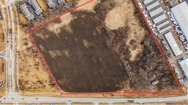
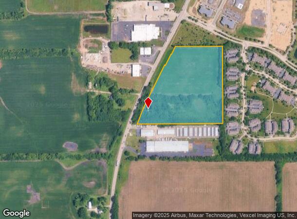
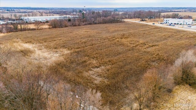
This Property Is For Sale
NEARBY LISTINGS FOR SALE OR LEASE
Property Detail
2002 S Il Route 31
Chicago-Naperville-Elgin, IL-IN-WI
None
14-10-452-001
McHenry
Residentialnec
Illinois
X
20 AC
17111C0220J
Far Northwest
2,116 SF
Chicago
DEMOGRAPHICS near 2002 S Il Route 31
1 Mile
3 Mile
5 Mile
2024 Total Population
1,495
25,739
75,373
2029 Population
1,515
26,103
75,910
Pop Growth 2024-2029
+ 1.34%
+ 1.41%
+ 0.71%
Average Age
43
43
42
2024 Total Households
674
10,012
28,725
HH Growth 2024-2029
+ 1.04%
+ 1.32%
+ 0.71%
Median Household Inc
$46,875
$83,356
$89,344
Avg Household Size
2.20
2.50
2.60
2024 Avg HH Vehicles
2.00
2.00
2.00
Median Home Value
$233,834
$254,056
$254,575
Median Year Built
1997
1989
1985
Nearby Places
Map Layers
Map Styles
 Street
 Aerial
- Restaurants
- Banks
- Shops
- Fitness
- Groceries
PUBLIC TRANSPORTATION
COMMUTER RAIL
Mchenry Station (Union Pacific Northwest Line - Northeast Illinois Regional Commuter Railroad (Metra))
DRIVE
WALK
Distance
Mchenry Station (Union Pacific Northwest Line - Northeast Illinois Regional Commuter Railroad (Metra))
6 min
3.2 mi
Crystal Lake Station (Union Pacific Northwest Line - Northeast Illinois Regional Commuter Railroad (Metra))
DRIVE
WALK
Distance
Crystal Lake Station (Union Pacific Northwest Line - Northeast Illinois Regional Commuter Railroad (Metra))
9 min
5.5 mi
AIRPORT
Chicago O'Hare International
DRIVE
WALK
Distance
Chicago O'Hare International
57 min
38.0 mi
Freight Ports
Port Milwaukee
DRIVE
WALK
Distance
Port Milwaukee
89 min
68.7 mi
Nearby Properties
Address
Land Use
TOTAL SIZE
Lot Size
Zoning
Address
Land Use
TOTAL SIZE
Lot Size
Zoning
279,418 SF
12.26 AC
Address
Land Use
TOTAL SIZE
Lot Size
Zoning
376,110 SF
13.46 AC
Address
Land Use
TOTAL SIZE
Lot Size
Zoning
54,986 SF
5.83 AC
Address
Land Use
TOTAL SIZE
Lot Size
Zoning
187,594 SF
6.36 AC
Address
Land Use
TOTAL SIZE
Lot Size
Zoning
47,440 SF
3.59 AC
Address
Land Use
TOTAL SIZE
Lot Size
Zoning
124,114 SF
6.05 AC
Address
Land Use
TOTAL SIZE
Lot Size
Zoning
218,524 SF
12.92 AC
Address
Land Use
TOTAL SIZE
Lot Size
Zoning
236,501 SF
10 AC
Address
Land Use
TOTAL SIZE
Lot Size
Zoning
233,785 SF
15.54 AC
Address
Land Use
TOTAL SIZE
Lot Size
Zoning
217,957 SF
18.53 AC
Address
Land Use
TOTAL SIZE
Lot Size
Zoning
81,264 SF
0.50 AC
Address
Land Use
TOTAL SIZE
Lot Size
Zoning
68,880 SF
13.39 AC
Address
Land Use
TOTAL SIZE
Lot Size
Zoning
72,624 SF
2.80 AC
Address
Land Use
TOTAL SIZE
Lot Size
Zoning
3.11 AC
Address
Land Use
TOTAL SIZE
Lot Size
Zoning
43.83 AC
Address
Land Use
TOTAL SIZE
Lot Size
Zoning
83,570 SF
3 AC
Address
Land Use
TOTAL SIZE
Lot Size
Zoning
83,744 SF
8.06 AC
Address
Land Use
TOTAL SIZE
Lot Size
Zoning
46,824 SF
6.68 AC
Address
Land Use
TOTAL SIZE
Lot Size
Zoning
94,900 SF
3.84 AC
Address
Land Use
TOTAL SIZE
Lot Size
Zoning
113,904 SF
6.02 AC
Address
Land Use
TOTAL SIZE
Lot Size
Zoning
10,432 SF
3 AC
Address
Land Use
TOTAL SIZE
Lot Size
Zoning
38,783 SF
10.92 AC
Address
Land Use
TOTAL SIZE
Lot Size
Zoning
68,604 SF
4.59 AC
Address
Land Use
TOTAL SIZE
Lot Size
Zoning
70,136 SF
3.15 AC
Address
Land Use
TOTAL SIZE
Lot Size
Zoning
60,757 SF
3.85 AC
Address
Land Use
TOTAL SIZE
Lot Size
Zoning
50,360 SF
3.46 AC
Address
Land Use
TOTAL SIZE
Lot Size
Zoning
3,840 SF
1 AC
Address
Land Use
TOTAL SIZE
Lot Size
Zoning
33,873 SF
3.97 AC
Address
Land Use
TOTAL SIZE
Lot Size
Zoning
23,006 SF
2 AC
Address
Land Use
TOTAL SIZE
Lot Size
Zoning
23,766 SF
3.86 AC
The World's #1 Commercial Real Estate Marketplace
Connect with us
© 2025 CoStar Group
The information above has been obtained from sources believed reliable. While we do not doubt its accuracy we have not verified it and make no guarantee, warranty or representation about it. It is your responsibility to independently confirm its accuracy and completeness. Any projections, opinions, assumptions, or estimates used are for example only and do not represent the current or future performance of the property. The value of this transaction to you depends on tax and other factors which should be evaluated by your tax, financial, and legal advisors. You and your advisors should conduct a careful, independent investigation of the property to determine to your satisfaction the suitability of the property for your needs.