Property Record
2002 W Republic Rd, Springfield, MO 65807

Property Detail
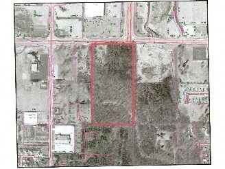
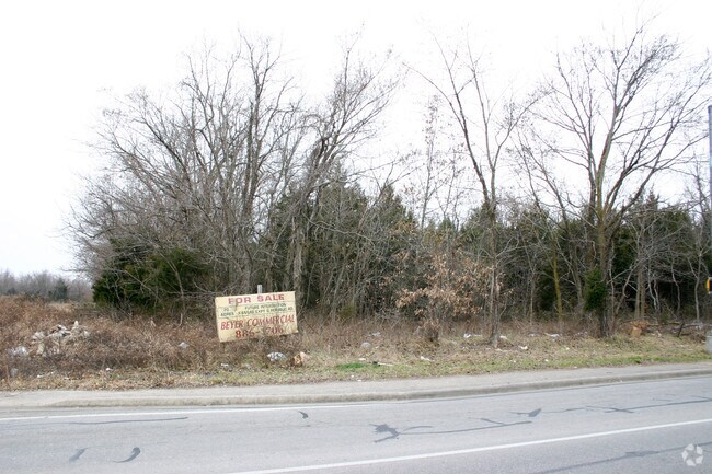
2002 W Republic Rd
18-15-101-003
15.75A M/L E1/2 NW1/4 NE1/4 15/28/22 (EX NEW R/W)
Agriculturalland
GREENE
INC
Missouri
B and X Area of moderate flood hazard, usually the area between the limits of the 100-year and 500-year floods.
15.75 AC
2025
Southwest
2025
Springfield
001401
Springfield, MO
NEARBY LISTINGS FOR SALE OR LEASE
DEMOGRAPHICS near 2002 W Republic Rd
1 mile
3 mile
5 mile
2024 Total Population
8,313
68,053
141,904
2029 Population
8,420
69,260
145,415
Pop Growth 2024-2029
+ 1.29%
+ 1.77%
+ 2.47%
Average Age
42
41
39
2024 Total Households
3,774
29,990
62,479
HH Growth 2024-2029
+ 1.35%
+ 1.83%
+ 2.59%
Median Household Inc
$66,157
$63,672
$58,984
Avg Household Size
2.10
2.20
2.20
2024 Avg HH Vehicles
2.00
2.00
2.00
Median Home Value
$263,165
$250,719
$242,477
Median Year Built
1991
1990
1986
Nearby Places
Map Layers
Map Styles
 Street
 Aerial
Transit
 Traffic
 Biking
Places
Listings with unknown addresses are not visible on the map
- Restaurants
- Banks
- Shops
- Fitness
- Groceries
PUBLIC TRANSPORTATION
AIRPORT
Springfield-Branson Ntl
Drive
Walk
Distance
Springfield-Branson Ntl
28 min
13.7 mi
Freight Ports
Tulsa Port of Inola
Drive
Walk
Distance
Tulsa Port of Inola
191 min
171.3 mi
SALE & LEASE HISTORY
LISTING DATE
SALE/LEASE

Sep 24, 2016
For Sale
Sep 24, 2016
For Sale
Jan 03, 2019
For Sale
Nearby Properties
Address
Land Use
TOTAL SIZE
Lot Size
Zoning
Address
Land Use
TOTAL SIZE
Lot Size
Zoning
18.52 AC
INC
Address
Land Use
TOTAL SIZE
Lot Size
Zoning
284,904 SF
24.38 AC
INC
Address
Land Use
TOTAL SIZE
Lot Size
Zoning
12.74 AC
Address
Land Use
TOTAL SIZE
Lot Size
Zoning
180,665 SF
6.36 AC
INC
Address
Land Use
TOTAL SIZE
Lot Size
Zoning
1.98 AC
INC.
Address
Land Use
TOTAL SIZE
Lot Size
Zoning
105,278 SF
0.54 AC
INC
Address
Land Use
TOTAL SIZE
Lot Size
Zoning
Address
Land Use
TOTAL SIZE
Lot Size
Zoning
108,880 SF
3.62 AC
INC
Address
Land Use
TOTAL SIZE
Lot Size
Zoning
312,092 SF
38 AC
INC
Address
Land Use
TOTAL SIZE
Lot Size
Zoning
2.76 AC
INC.
Address
Land Use
TOTAL SIZE
Lot Size
Zoning
614,588 SF
57.27 AC
INC
Address
Land Use
TOTAL SIZE
Lot Size
Zoning
26.03 AC
INC
Address
Land Use
TOTAL SIZE
Lot Size
Zoning
129,652 SF
16.40 AC
INC
Address
Land Use
TOTAL SIZE
Lot Size
Zoning
11.56 AC
INC
Address
Land Use
TOTAL SIZE
Lot Size
Zoning
9.82 AC
INC
Address
Land Use
TOTAL SIZE
Lot Size
Zoning
140,147 SF
17.64 AC
INC
Address
Land Use
TOTAL SIZE
Lot Size
Zoning
159,007 SF
16.05 AC
INC
Address
Land Use
TOTAL SIZE
Lot Size
Zoning
42,540 SF
3.63 AC
INC
Address
Land Use
TOTAL SIZE
Lot Size
Zoning
30,400 SF
9.05 AC
INC
Address
Land Use
TOTAL SIZE
Lot Size
Zoning
27.78 AC
INC
Address
Land Use
TOTAL SIZE
Lot Size
Zoning
86,566 SF
9.63 AC
INC
Address
Land Use
TOTAL SIZE
Lot Size
Zoning
6.24 AC
INC
Address
Land Use
TOTAL SIZE
Lot Size
Zoning
Address
Land Use
TOTAL SIZE
Lot Size
Zoning
89,310 SF
10.89 AC
INC
Address
Land Use
TOTAL SIZE
Lot Size
Zoning
12.81 AC
INC
Address
Land Use
TOTAL SIZE
Lot Size
Zoning
47,214 SF
4.25 AC
INC
Address
Land Use
TOTAL SIZE
Lot Size
Zoning
10.53 AC
Address
Land Use
TOTAL SIZE
Lot Size
Zoning
237,818 SF
20.86 AC
INC
Address
Land Use
TOTAL SIZE
Lot Size
Zoning
8.82 AC
INC
Address
Land Use
TOTAL SIZE
Lot Size
Zoning
6.53 AC
INC.
The World's #1 Commercial Real Estate Marketplace
Connect with us
© 2026 CoStar Group
The information above has been obtained from sources believed reliable. While we do not doubt its accuracy we have not verified it and make no guarantee, warranty or representation about it. It is your responsibility to independently confirm its accuracy and completeness. Any projections, opinions, assumptions, or estimates used are for example only and do not represent the current or future performance of the property. The value of this transaction to you depends on tax and other factors which should be evaluated by your tax, financial, and legal advisors. You and your advisors should conduct a careful, independent investigation of the property to determine to your satisfaction the suitability of the property for your needs.