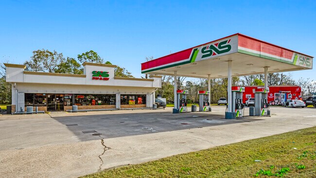
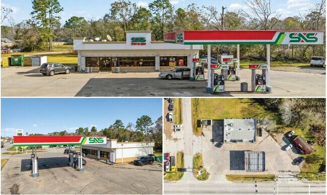
Property Record
20025 Fm 1485 Rd, New Caney, TX 77357
NEARBY LISTINGS FOR SALE OR LEASE
Property Detail
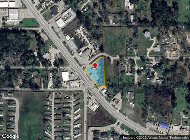
20025 Fm 1485 Rd
Houston-The Woodlands-Sugar Land, TX
Lynch Wm
0308-01-00801
A0308 LYNCH WM, TRACT 8 LT 1, ACRES 0.988
Commercialnec
Montgomery
X
Texas
48339C0600G
1
2024
0.99 AC
2025
Montgomery County
692702
Houston
3,120 SF
DEMOGRAPHICS near 20025 Fm 1485 Rd
1 Mile
3 Mile
5 Mile
2024 Total Population
3,556
30,592
70,694
2029 Population
4,394
38,182
87,715
Pop Growth 2024-2029
+ 23.57%
+ 24.81%
+ 24.08%
Average Age
34
35
35
2024 Total Households
1,189
10,038
22,960
HH Growth 2024-2029
+ 23.72%
+ 25.01%
+ 24.30%
Median Household Inc
$74,852
$79,560
$75,869
Avg Household Size
2.90
3.00
3.00
2024 Avg HH Vehicles
2.00
2.00
2.00
Median Home Value
$124,193
$225,644
$227,237
Median Year Built
1995
2007
2004
Nearby Places
Map Layers
Map Styles
 Street
 Aerial
- Restaurants
- Banks
- Shops
- Fitness
- Groceries
PUBLIC TRANSPORTATION
AIRPORT
George Bush Intcntl/Houston
DRIVE
WALK
Distance
George Bush Intcntl/Houston
25 min
20.0 mi
Freight Ports
Port of Houston
DRIVE
WALK
Distance
Port of Houston
47 min
35.3 mi
SALE & LEASE HISTORY
LISTING DATE
SALE/LEASE

Jan 24, 2025
For Sale
Nearby Properties
Address
Land Use
TOTAL SIZE
Lot Size
Zoning
Address
Land Use
TOTAL SIZE
Lot Size
Zoning
430,982 SF
21.50 AC
Address
Land Use
TOTAL SIZE
Lot Size
Zoning
298,715 SF
16.28 AC
Address
Land Use
TOTAL SIZE
Lot Size
Zoning
444,537 SF
55.21 AC
5
Address
Land Use
TOTAL SIZE
Lot Size
Zoning
274,809 SF
11.89 AC
Address
Land Use
TOTAL SIZE
Lot Size
Zoning
29,782 SF
28.69 AC
Address
Land Use
TOTAL SIZE
Lot Size
Zoning
154,584 SF
46.76 AC
Address
Land Use
TOTAL SIZE
Lot Size
Zoning
161,302 SF
60.09 AC
5
Address
Land Use
TOTAL SIZE
Lot Size
Zoning
187,696 SF
20.07 AC
Address
Land Use
TOTAL SIZE
Lot Size
Zoning
149,963 SF
49.98 AC
Address
Land Use
TOTAL SIZE
Lot Size
Zoning
76,292 SF
32.01 AC
5
Address
Land Use
TOTAL SIZE
Lot Size
Zoning
165,381 SF
16.60 AC
Address
Land Use
TOTAL SIZE
Lot Size
Zoning
224,810 SF
21.64 AC
5
Address
Land Use
TOTAL SIZE
Lot Size
Zoning
121,871 SF
12.59 AC
Address
Land Use
TOTAL SIZE
Lot Size
Zoning
131,364 SF
4.63 AC
5
Address
Land Use
TOTAL SIZE
Lot Size
Zoning
131,028 SF
9.46 AC
Address
Land Use
TOTAL SIZE
Lot Size
Zoning
128,724 SF
29.89 AC
Address
Land Use
TOTAL SIZE
Lot Size
Zoning
110,013 SF
13.91 AC
5
Address
Land Use
TOTAL SIZE
Lot Size
Zoning
102,184 SF
20.35 AC
Address
Land Use
TOTAL SIZE
Lot Size
Zoning
72,839 SF
5.91 AC
Address
Land Use
TOTAL SIZE
Lot Size
Zoning
53,236 SF
6.80 AC
Address
Land Use
TOTAL SIZE
Lot Size
Zoning
102,279 SF
2.18 AC
Address
Land Use
TOTAL SIZE
Lot Size
Zoning
47,145 SF
4.31 AC
Address
Land Use
TOTAL SIZE
Lot Size
Zoning
103,709 SF
17.58 AC
5
Address
Land Use
TOTAL SIZE
Lot Size
Zoning
90,133 SF
11.91 AC
5
Address
Land Use
TOTAL SIZE
Lot Size
Zoning
54,372 SF
6.26 AC
Address
Land Use
TOTAL SIZE
Lot Size
Zoning
61,628 SF
30.91 AC
5
Address
Land Use
TOTAL SIZE
Lot Size
Zoning
69,560 SF
16.91 AC
5
Address
Land Use
TOTAL SIZE
Lot Size
Zoning
65,640 SF
9.37 AC
Address
Land Use
TOTAL SIZE
Lot Size
Zoning
26,036 SF
3.10 AC
Address
Land Use
TOTAL SIZE
Lot Size
Zoning
55,425 SF
4.82 AC
The World's #1 Commercial Real Estate Marketplace
Connect with us
© 2025 CoStar Group
The information above has been obtained from sources believed reliable. While we do not doubt its accuracy we have not verified it and make no guarantee, warranty or representation about it. It is your responsibility to independently confirm its accuracy and completeness. Any projections, opinions, assumptions, or estimates used are for example only and do not represent the current or future performance of the property. The value of this transaction to you depends on tax and other factors which should be evaluated by your tax, financial, and legal advisors. You and your advisors should conduct a careful, independent investigation of the property to determine to your satisfaction the suitability of the property for your needs.