Property Record
2004 W State Highway 71 Byp, La Grange, TX 78945

Property Detail
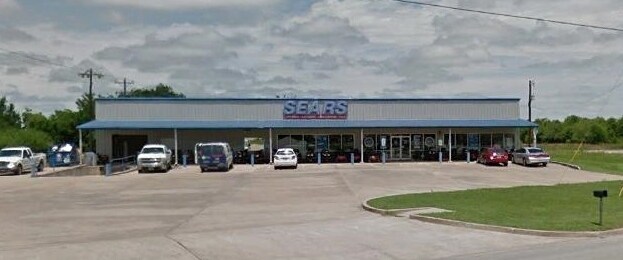
2004 W State Highway 71 Byp
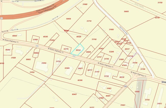
R58154
RIVERSIDE COMM.ACREAGE 1.002 COMM - LG SPIRITS & WINE
Commercialnec
FAYETTE
B and X Area of moderate flood hazard, usually the area between the limits of the 100-year and 500-year floods.
Texas
2025
1 AC
2025
Central Texas Area
970301
Other Market Areas
10,922 SF
NEARBY LISTINGS FOR SALE OR LEASE
-
-
View all La Grange listings for lease on LoopNet.com
DEMOGRAPHICS near 2004 W State Highway 71 Byp
1 mile
3 mile
5 mile
2025 Total Population
119
6,621
8,541
2030 Population
121
6,921
8,898
Pop Growth 2025-2030
+ 1.68%
+ 4.53%
+ 4.18%
Average Age
47
42
43
2025 Total Households
44
2,619
3,396
HH Growth 2025-2030
+ 2.27%
+ 4.43%
+ 4.06%
Median Household Inc
$102,083
$73,605
$79,379
Avg Household Size
2.50
2.40
2.40
2025 Avg HH Vehicles
2.00
2.00
2.00
Median Home Value
$287,499
$328,952
$328,626
Median Year Built
1983
1977
1979
Nearby Places
Map Layers
Map Styles
 Street
 Aerial
Transit
 Traffic
 Biking
Places
Listings with unknown addresses are not visible on the map
- Restaurants
- Banks
- Shops
- Fitness
- Groceries
SALE & LEASE HISTORY
LISTING DATE
SALE/LEASE

Aug 14, 2017
For Sale
Aug 09, 2019
For Lease
Nearby Properties
Address
Land Use
TOTAL SIZE
Lot Size
Zoning
Address
Land Use
TOTAL SIZE
Lot Size
Zoning
185,403 SF
84.21 AC
Address
Land Use
TOTAL SIZE
Lot Size
Zoning
226,797 SF
16.95 AC
Address
Land Use
TOTAL SIZE
Lot Size
Zoning
100,385 SF
19.96 AC
Address
Land Use
TOTAL SIZE
Lot Size
Zoning
119,697 SF
7.68 AC
Address
Land Use
TOTAL SIZE
Lot Size
Zoning
8,065 SF
324.83 AC
Address
Land Use
TOTAL SIZE
Lot Size
Zoning
47,715 SF
6.20 AC
Address
Land Use
TOTAL SIZE
Lot Size
Zoning
61.39 AC
Address
Land Use
TOTAL SIZE
Lot Size
Zoning
31,904 SF
4.08 AC
Address
Land Use
TOTAL SIZE
Lot Size
Zoning
286.30 AC
Address
Land Use
TOTAL SIZE
Lot Size
Zoning
86.47 AC
Address
Land Use
TOTAL SIZE
Lot Size
Zoning
23,081 SF
2.61 AC
Address
Land Use
TOTAL SIZE
Lot Size
Zoning
47,411 SF
3.72 AC
Address
Land Use
TOTAL SIZE
Lot Size
Zoning
1,180 SF
224.55 AC
Address
Land Use
TOTAL SIZE
Lot Size
Zoning
46,316 SF
80.33 AC
Address
Land Use
TOTAL SIZE
Lot Size
Zoning
3,505 SF
97.73 AC
Address
Land Use
TOTAL SIZE
Lot Size
Zoning
216.38 AC
Address
Land Use
TOTAL SIZE
Lot Size
Zoning
32,277 SF
1.62 AC
Address
Land Use
TOTAL SIZE
Lot Size
Zoning
1,454 SF
199.91 AC
Address
Land Use
TOTAL SIZE
Lot Size
Zoning
17,689 SF
3.73 AC
Address
Land Use
TOTAL SIZE
Lot Size
Zoning
20,884 SF
1.27 AC
Address
Land Use
TOTAL SIZE
Lot Size
Zoning
21,846 SF
5.22 AC
Address
Land Use
TOTAL SIZE
Lot Size
Zoning
1,490 SF
301.50 AC
Address
Land Use
TOTAL SIZE
Lot Size
Zoning
9,245 SF
182.28 AC
Address
Land Use
TOTAL SIZE
Lot Size
Zoning
38,804 SF
7.04 AC
Address
Land Use
TOTAL SIZE
Lot Size
Zoning
27,766 SF
1.72 AC
Address
Land Use
TOTAL SIZE
Lot Size
Zoning
46,589 SF
2.56 AC
Address
Land Use
TOTAL SIZE
Lot Size
Zoning
1,950 SF
227.40 AC
Address
Land Use
TOTAL SIZE
Lot Size
Zoning
11,649 SF
232.07 AC
Address
Land Use
TOTAL SIZE
Lot Size
Zoning
55,040 SF
5.36 AC
Address
Land Use
TOTAL SIZE
Lot Size
Zoning
31,200 SF
3.15 AC
The World's #1 Commercial Real Estate Marketplace
Connect with us
© 2026 CoStar Group
The information above has been obtained from sources believed reliable. While we do not doubt its accuracy we have not verified it and make no guarantee, warranty or representation about it. It is your responsibility to independently confirm its accuracy and completeness. Any projections, opinions, assumptions, or estimates used are for example only and do not represent the current or future performance of the property. The value of this transaction to you depends on tax and other factors which should be evaluated by your tax, financial, and legal advisors. You and your advisors should conduct a careful, independent investigation of the property to determine to your satisfaction the suitability of the property for your needs.