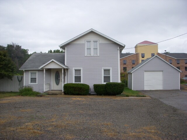
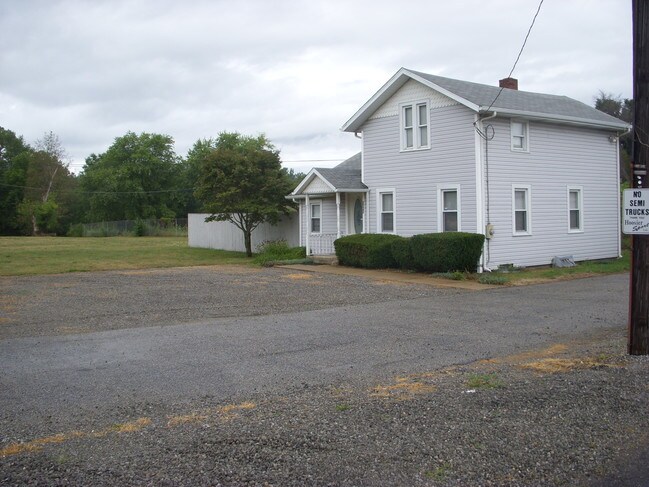
Property Record
20047 Kern Rd, South Bend, IN 46614

NEARBY LISTINGS FOR SALE OR LEASE
-
-
View all South Bend listings for sale on LoopNet.com
Property Detail
20047 Kern Rd
71-08-35-476-014.000-001
305 N SIDE KERN RD. X 132 BEG 198 W OF SE COR SE SEC 35-37-2E .92 AC
Commercialacreage
St Joseph
X
Indiana
18141C0307D
0.13 AC
2023
Outlying St Joseph County
2024
South Bend/Mishawaka
011804
South Bend-Mishawaka, IN-MI
1,872 SF
DEMOGRAPHICS near 20047 Kern Rd
1 Mile
3 Mile
5 Mile
2024 Total Population
3,871
23,251
79,473
2029 Population
3,810
22,926
79,494
Pop Growth 2024-2029
(1.58%)
(1.40%)
+ 0.03%
Average Age
44
42
38
2024 Total Households
1,575
9,748
31,744
HH Growth 2024-2029
(1.65%)
(1.48%)
(0.05%)
Median Household Inc
$81,489
$67,187
$50,065
Avg Household Size
2.40
2.30
2.40
2024 Avg HH Vehicles
2.00
2.00
2.00
Median Home Value
$212,121
$166,884
$129,327
Median Year Built
1971
1966
1957
Nearby Places
Map Layers
Map Styles
 Street
 Aerial
- Restaurants
- Banks
- Shops
- Fitness
- Groceries
PUBLIC TRANSPORTATION
COMMUTER RAIL
South Bend Amtrak Station (Capitol Limited - Amtrak, Lake Shore Limited - Amtrak)
DRIVE
WALK
Distance
South Bend Amtrak Station (Capitol Limited - Amtrak, Lake Shore Limited - Amtrak)
13 min
7.4 mi
South Bend Airport Station (South Shore Line - Northern Indiana Commuter Transportation District (South Shore Line))
DRIVE
WALK
Distance
South Bend Airport Station (South Shore Line - Northern Indiana Commuter Transportation District (South Shore Line))
16 min
9.7 mi
AIRPORT
South Bend International
DRIVE
WALK
Distance
South Bend International
23 min
10.6 mi
Freight Ports
Port Milwaukee
DRIVE
WALK
Distance
Port Milwaukee
222 min
184.8 mi
Nearby Properties
Address
Land Use
TOTAL SIZE
Lot Size
Zoning
Address
Land Use
TOTAL SIZE
Lot Size
Zoning
270,484 SF
131 SF
Address
Land Use
TOTAL SIZE
Lot Size
Zoning
231,450 SF
87 SF
Address
Land Use
TOTAL SIZE
Lot Size
Zoning
25,228 SF
68.61 AC
Address
Land Use
TOTAL SIZE
Lot Size
Zoning
221,887 SF
87 SF
Address
Land Use
TOTAL SIZE
Lot Size
Zoning
174,526 SF
24.37 AC
Address
Land Use
TOTAL SIZE
Lot Size
Zoning
91,091 SF
131 SF
Address
Land Use
TOTAL SIZE
Lot Size
Zoning
136,568 SF
44 SF
Address
Land Use
TOTAL SIZE
Lot Size
Zoning
79,760 SF
13.17 AC
Address
Land Use
TOTAL SIZE
Lot Size
Zoning
123,359 SF
44 SF
Address
Land Use
TOTAL SIZE
Lot Size
Zoning
87,310 SF
44 SF
Address
Land Use
TOTAL SIZE
Lot Size
Zoning
93,530 SF
8.08 AC
Address
Land Use
TOTAL SIZE
Lot Size
Zoning
15,436 SF
174 SF
Address
Land Use
TOTAL SIZE
Lot Size
Zoning
62,834 SF
87 SF
Address
Land Use
TOTAL SIZE
Lot Size
Zoning
4,464 SF
131 SF
Address
Land Use
TOTAL SIZE
Lot Size
Zoning
52,648 SF
2.80 AC
Address
Land Use
TOTAL SIZE
Lot Size
Zoning
93,376 SF
23.93 AC
Address
Land Use
TOTAL SIZE
Lot Size
Zoning
48,204 SF
44 SF
Address
Land Use
TOTAL SIZE
Lot Size
Zoning
52,500 SF
32.50 AC
Address
Land Use
TOTAL SIZE
Lot Size
Zoning
1,418,289 SF
74.42 AC
Address
Land Use
TOTAL SIZE
Lot Size
Zoning
161,462 SF
18 AC
Address
Land Use
TOTAL SIZE
Lot Size
Zoning
322,768 SF
26.46 AC
Address
Land Use
TOTAL SIZE
Lot Size
Zoning
20,277 SF
8.95 AC
Address
Land Use
TOTAL SIZE
Lot Size
Zoning
63,969 SF
9.20 AC
Address
Land Use
TOTAL SIZE
Lot Size
Zoning
35,702 SF
44.52 AC
Address
Land Use
TOTAL SIZE
Lot Size
Zoning
11,581 SF
0.01 AC
Address
Land Use
TOTAL SIZE
Lot Size
Zoning
46,337 SF
87 SF
Address
Land Use
TOTAL SIZE
Lot Size
Zoning
151,556 SF
9.13 AC
Address
Land Use
TOTAL SIZE
Lot Size
Zoning
18,101 SF
1.84 AC
Address
Land Use
TOTAL SIZE
Lot Size
Zoning
68,056 SF
7.16 AC
Address
Land Use
TOTAL SIZE
Lot Size
Zoning
127,520 SF
8.46 AC
The World's #1 Commercial Real Estate Marketplace
Connect with us
© 2026 CoStar Group
The information above has been obtained from sources believed reliable. While we do not doubt its accuracy we have not verified it and make no guarantee, warranty or representation about it. It is your responsibility to independently confirm its accuracy and completeness. Any projections, opinions, assumptions, or estimates used are for example only and do not represent the current or future performance of the property. The value of this transaction to you depends on tax and other factors which should be evaluated by your tax, financial, and legal advisors. You and your advisors should conduct a careful, independent investigation of the property to determine to your satisfaction the suitability of the property for your needs.