Property Record
2005 Cabintown Rd, Bloomington, IL 61701
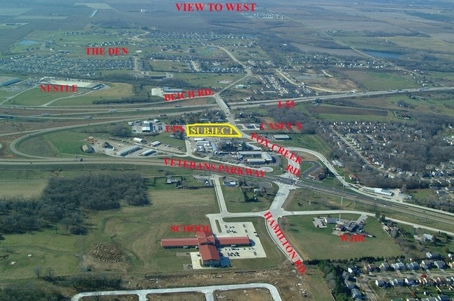

Property Detail
2005 Cabintown Rd
Bloomington, IL
SUB L47 SUB 17-23-2E BEG 304.87, W OF N 1N CABINTOWN RD & W ROW 1N US 66 W125
21-17-302-011
MCLEAN
Commercialnec
Illinois
B and X Area of moderate flood hazard, usually the area between the limits of the 100-year and 500-year floods.
47
2022
2.37 AC
2024
Bloomington/Normal
001404
Other Market Areas
13,336 SF
NEARBY LISTINGS FOR SALE OR LEASE
-
-
No Photo
-
-
View all Bloomington listings for sale on LoopNet.com
DEMOGRAPHICS near 2005 Cabintown Rd
1 mile
3 mile
5 mile
2025 Total Population
5,734
33,782
85,478
2030 Population
5,838
34,260
86,003
Pop Growth 2025-2030
+ 1.81%
+ 1.41%
+ 0.61%
Average Age
40
39
37
2025 Total Households
2,358
15,049
35,712
HH Growth 2025-2030
+ 1.99%
+ 1.49%
+ 0.65%
Median Household Inc
$98,112
$57,131
$60,519
Avg Household Size
2.40
2.10
2.10
2025 Avg HH Vehicles
2.00
2.00
2.00
Median Home Value
$239,478
$155,957
$183,694
Median Year Built
1995
1971
1974
Nearby Places
Map Layers
Map Styles
 Street
 Aerial
Transit
 Traffic
 Biking
Places
Listings with unknown addresses are not visible on the map
- Restaurants
- Banks
- Shops
- Fitness
- Groceries
PUBLIC TRANSPORTATION
COMMUTER RAIL
Drive
Walk
Distance
14 min
5.5 mi
AIRPORT
Central Il Regional/Bloomington-Normal
Drive
Walk
Distance
Central Il Regional/Bloomington-Normal
18 min
7.9 mi
Nearby Properties
Address
Land Use
TOTAL SIZE
Lot Size
Zoning
Address
Land Use
TOTAL SIZE
Lot Size
Zoning
228,378 SF
7.99 AC
Address
Land Use
TOTAL SIZE
Lot Size
Zoning
200,445 SF
8.33 AC
Address
Land Use
TOTAL SIZE
Lot Size
Zoning
275,860 SF
12.17 AC
Address
Land Use
TOTAL SIZE
Lot Size
Zoning
2,907 SF
96.29 AC
Address
Land Use
TOTAL SIZE
Lot Size
Zoning
399,682 SF
18.08 AC
Address
Land Use
TOTAL SIZE
Lot Size
Zoning
118,176 SF
2.30 AC
Address
Land Use
TOTAL SIZE
Lot Size
Zoning
97,514 SF
2.70 AC
Address
Land Use
TOTAL SIZE
Lot Size
Zoning
98,540 SF
6.49 AC
Address
Land Use
TOTAL SIZE
Lot Size
Zoning
770,588 SF
54.24 AC
Address
Land Use
TOTAL SIZE
Lot Size
Zoning
196,500 SF
5.07 AC
Address
Land Use
TOTAL SIZE
Lot Size
Zoning
1,792 SF
31.52 AC
Address
Land Use
TOTAL SIZE
Lot Size
Zoning
34.42 AC
Address
Land Use
TOTAL SIZE
Lot Size
Zoning
3,840 SF
61.03 AC
Address
Land Use
TOTAL SIZE
Lot Size
Zoning
5,569 SF
9.94 AC
Address
Land Use
TOTAL SIZE
Lot Size
Zoning
86,837 SF
1.13 AC
Address
Land Use
TOTAL SIZE
Lot Size
Zoning
180,900 SF
0.36 AC
Address
Land Use
TOTAL SIZE
Lot Size
Zoning
222,094 SF
6.24 AC
Address
Land Use
TOTAL SIZE
Lot Size
Zoning
522,552 SF
7.60 AC
Address
Land Use
TOTAL SIZE
Lot Size
Zoning
17,037 SF
0.70 AC
Address
Land Use
TOTAL SIZE
Lot Size
Zoning
9,433 SF
5.92 AC
Address
Land Use
TOTAL SIZE
Lot Size
Zoning
61,500 SF
3.33 AC
Address
Land Use
TOTAL SIZE
Lot Size
Zoning
139,321 SF
10 AC
Address
Land Use
TOTAL SIZE
Lot Size
Zoning
106,175 SF
4.68 AC
Address
Land Use
TOTAL SIZE
Lot Size
Zoning
122,853 SF
0.75 AC
Address
Land Use
TOTAL SIZE
Lot Size
Zoning
58,308 SF
8.66 AC
Address
Land Use
TOTAL SIZE
Lot Size
Zoning
35.38 AC
Address
Land Use
TOTAL SIZE
Lot Size
Zoning
58,904 SF
2.17 AC
Address
Land Use
TOTAL SIZE
Lot Size
Zoning
55,619 SF
2.27 AC
Address
Land Use
TOTAL SIZE
Lot Size
Zoning
56,828 SF
1.82 AC
The World's #1 Commercial Real Estate Marketplace
Connect with us
© 2026 CoStar Group
The information above has been obtained from sources believed reliable. While we do not doubt its accuracy we have not verified it and make no guarantee, warranty or representation about it. It is your responsibility to independently confirm its accuracy and completeness. Any projections, opinions, assumptions, or estimates used are for example only and do not represent the current or future performance of the property. The value of this transaction to you depends on tax and other factors which should be evaluated by your tax, financial, and legal advisors. You and your advisors should conduct a careful, independent investigation of the property to determine to your satisfaction the suitability of the property for your needs.