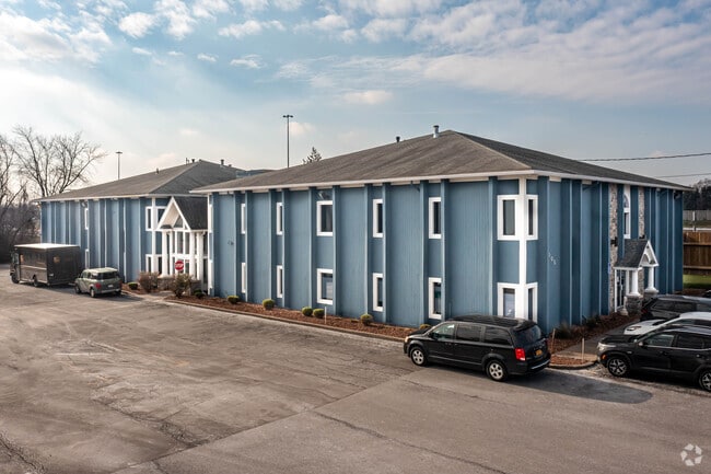
Property Record
2005 Lyell Ave, Rochester, NY 14606


Save to a Folder
{{folder.Name}}
{{folder.ListingIds.length}} Properties
{{folder.ListingIds.length}} Property
Create a New Folder
Current Lease Availabilities
Property Detail
2005 Lyell Ave
262600 104.19-3-10.21
MONROE
Officebuilding
New York
06 - INDUS
10.210
B and X Area of moderate flood hazard, usually the area between the limits of the 100-year and 500-year floods.
1.56 AC
2025
Southwest
2025
Rochester
014302
Rochester, NY
20,781 SF
NEARBY LISTINGS FOR SALE OR LEASE
DEMOGRAPHICS near 2005 Lyell Ave
1 mile
3 mile
5 mile
2025 Total Population
5,129
90,693
249,234
2030 Population
5,049
89,447
246,815
Pop Growth 2025-2030
(1.56%)
(1.37%)
(0.97%)
Average Age
44
39
39
2025 Total Households
2,343
36,461
108,414
HH Growth 2025-2030
(1.58%)
(1.41%)
(0.96%)
Median Household Inc
$52,074
$51,842
$54,170
Avg Household Size
2.20
2.40
2.20
2025 Avg HH Vehicles
2.00
1.00
1.00
Median Home Value
$142,204
$138,579
$155,107
Median Year Built
1962
1951
1955
Nearby Places
Map Layers
Map Styles
 Street
 Aerial
Layers
 Traffic
 Biking
Places
Listings with unknown addresses are not visible on the map
- Restaurants
- Banks
- Shops
- Fitness
- Groceries
PUBLIC TRANSPORTATION
AIRPORT
Frederick Douglass/Greater Rochester International
Drive
Walk
Distance
Frederick Douglass/Greater Rochester International
9 min
5.1 mi
Nearby Properties
Address
Land Use
TOTAL SIZE
Lot Size
Zoning
Address
Land Use
TOTAL SIZE
Lot Size
Zoning
60,300 SF
59.02 AC
06 - INDUS
Address
Land Use
TOTAL SIZE
Lot Size
Zoning
348,895 SF
76.07 AC
06 - INDUS
Address
Land Use
TOTAL SIZE
Lot Size
Zoning
200,000 SF
764.91 AC
Address
Land Use
TOTAL SIZE
Lot Size
Zoning
181,500 SF
57.85 AC
Address
Land Use
TOTAL SIZE
Lot Size
Zoning
64,041 SF
42.66 AC
Address
Land Use
TOTAL SIZE
Lot Size
Zoning
57,550 SF
46.61 AC
05 - COMME
Address
Land Use
TOTAL SIZE
Lot Size
Zoning
11,408 SF
98.28 AC
02 - SINGL
Address
Land Use
TOTAL SIZE
Lot Size
Zoning
13.10 AC
Address
Land Use
TOTAL SIZE
Lot Size
Zoning
540,000 SF
39.70 AC
06 - INDUS
Address
Land Use
TOTAL SIZE
Lot Size
Zoning
119,777 SF
14.38 AC
06 - INDUS
Address
Land Use
TOTAL SIZE
Lot Size
Zoning
201,774 SF
17.17 AC
05 - COMME
Address
Land Use
TOTAL SIZE
Lot Size
Zoning
1.06 AC
Address
Land Use
TOTAL SIZE
Lot Size
Zoning
14,219 SF
2.34 AC
Address
Land Use
TOTAL SIZE
Lot Size
Zoning
83,632 SF
3.48 AC
02 - SINGL
Address
Land Use
TOTAL SIZE
Lot Size
Zoning
5,580 SF
21.86 AC
03 - MULTI
Address
Land Use
TOTAL SIZE
Lot Size
Zoning
149,541 SF
6.10 AC
03 - MULTI
Address
Land Use
TOTAL SIZE
Lot Size
Zoning
2.63 AC
Address
Land Use
TOTAL SIZE
Lot Size
Zoning
0.01 AC
Address
Land Use
TOTAL SIZE
Lot Size
Zoning
274,700 SF
24.79 AC
Address
Land Use
TOTAL SIZE
Lot Size
Zoning
6,617 SF
274.69 AC
Address
Land Use
TOTAL SIZE
Lot Size
Zoning
3,281 SF
17.99 AC
Address
Land Use
TOTAL SIZE
Lot Size
Zoning
391,478 SF
29.27 AC
Address
Land Use
TOTAL SIZE
Lot Size
Zoning
116,193 SF
12.23 AC
05 - COMME
Address
Land Use
TOTAL SIZE
Lot Size
Zoning
250,500 SF
18 AC
Address
Land Use
TOTAL SIZE
Lot Size
Zoning
119,983 SF
17.80 AC
03 - MULTI
Address
Land Use
TOTAL SIZE
Lot Size
Zoning
1,899,594 SF
87.90 AC
Address
Land Use
TOTAL SIZE
Lot Size
Zoning
374,864 SF
25.87 AC
Address
Land Use
TOTAL SIZE
Lot Size
Zoning
8.86 AC
Address
Land Use
TOTAL SIZE
Lot Size
Zoning
9,280 SF
24.89 AC
03 - MULTI
Address
Land Use
TOTAL SIZE
Lot Size
Zoning
67,000 SF
3.86 AC
The World's #1 Commercial Real Estate Marketplace
Connect with us
© 2026 CoStar Group
The information above has been obtained from sources believed reliable. While we do not doubt its accuracy we have not verified it and make no guarantee, warranty or representation about it. It is your responsibility to independently confirm its accuracy and completeness. Any projections, opinions, assumptions, or estimates used are for example only and do not represent the current or future performance of the property. The value of this transaction to you depends on tax and other factors which should be evaluated by your tax, financial, and legal advisors. You and your advisors should conduct a careful, independent investigation of the property to determine to your satisfaction the suitability of the property for your needs.