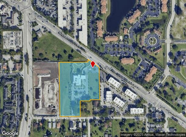
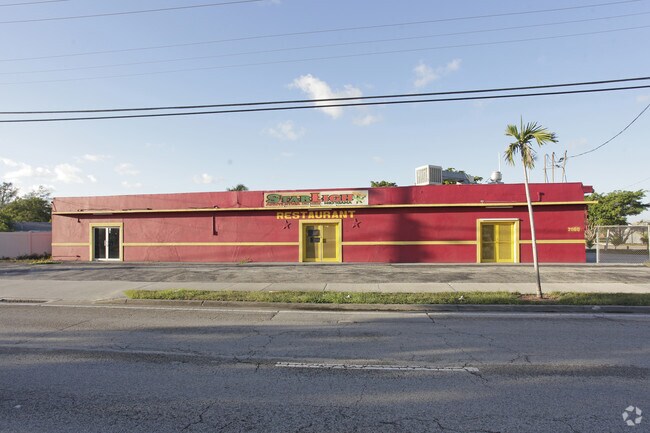
Property Record
2005 Nw 9Th St, Pompano Beach, FL 33069


NEARBY LISTINGS FOR SALE OR LEASE
Property Detail
2005 Nw 9Th St
48-42-34-27-0010
Renteria Inc Plat 166-33 B
Municipalproperty
RENTERIA INC PLAT 166-33 B PARCEL A & B TOG/W N 100 OF S 300 OF W 150 OF E1/2 OF NW1/4 OF SW 1/4 OF NW1/4 OF 34-48-42,& TOG/W POR DESC AS S 200 OF E1/2 OF E1/2 OF NW1/4 OF SW 1/4 OF NW1/4 OF 34-48-42 LESS E 100 & LESS W 15 & LESS S 15 FOR CO RD, & TO
AH
Broward
12011C0357J
Florida
0
5.58 AC
2026
Pompano Beach
030500
South Florida
10,335 SF
Fort Lauderdale-Pompano Beach-Sunrise, FL
DEMOGRAPHICS near 2005 Nw 9Th St
1 Mile
3 Mile
5 Mile
2024 Total Population
10,230
113,749
374,035
2029 Population
10,200
114,566
376,107
Pop Growth 2024-2029
(0.29%)
+ 0.72%
+ 0.55%
Average Age
34
42
43
2024 Total Households
2,751
46,871
156,728
HH Growth 2024-2029
(0.58%)
+ 0.66%
+ 0.63%
Median Household Inc
$42,261
$53,426
$59,495
Avg Household Size
3.00
2.30
2.30
2024 Avg HH Vehicles
2.00
1.00
2.00
Median Home Value
$211,295
$236,321
$302,383
Median Year Built
1985
1978
1976
Nearby Places
Map Layers
Map Styles
 Street
 Aerial
- Restaurants
- Banks
- Shops
- Fitness
- Groceries
PUBLIC TRANSPORTATION
COMMUTER RAIL
Pompano Beach (Tri-County Commuter - South Florida Regional Transportation Authority (Tri-Rail))
DRIVE
WALK
Distance
Pompano Beach (Tri-County Commuter - South Florida Regional Transportation Authority (Tri-Rail))
9 min
3.4 mi
Cypress Creek (Tri-County Commuter - South Florida Regional Transportation Authority (Tri-Rail))
DRIVE
WALK
Distance
Cypress Creek (Tri-County Commuter - South Florida Regional Transportation Authority (Tri-Rail))
8 min
3.6 mi
AIRPORT
Fort Lauderdale/Hollywood International
DRIVE
WALK
Distance
Fort Lauderdale/Hollywood International
24 min
15.2 mi
Palm Beach International
DRIVE
WALK
Distance
Palm Beach International
48 min
36.3 mi
Miami International
DRIVE
WALK
Distance
Miami International
60 min
40.4 mi
Freight Ports
Port Everglades
DRIVE
WALK
Distance
Port Everglades
22 min
14.2 mi
Nearby Properties
Address
Land Use
TOTAL SIZE
Lot Size
Zoning
Address
Land Use
TOTAL SIZE
Lot Size
Zoning
1,724,503 SF
64.97 AC
LAC
Address
Land Use
TOTAL SIZE
Lot Size
Zoning
696,020 SF
31.74 AC
OPC
Address
Land Use
TOTAL SIZE
Lot Size
Zoning
32,538 SF
331.51 AC
P
Address
Land Use
TOTAL SIZE
Lot Size
Zoning
425,379 SF
26.84 AC
RPUD
Address
Land Use
TOTAL SIZE
Lot Size
Zoning
513,748 SF
2.99 AC
TO-EOD
Address
Land Use
TOTAL SIZE
Lot Size
Zoning
561,250 SF
137.82 AC
T
Address
Land Use
TOTAL SIZE
Lot Size
Zoning
467,722 SF
36.71 AC
I-1
Address
Land Use
TOTAL SIZE
Lot Size
Zoning
667,120 SF
12.75 AC
PCD
Address
Land Use
TOTAL SIZE
Lot Size
Zoning
297,289 SF
2.45 AC
UUV-NE
Address
Land Use
TOTAL SIZE
Lot Size
Zoning
365,849 SF
25.66 AC
RM-10
Address
Land Use
TOTAL SIZE
Lot Size
Zoning
649,284 SF
62.54 AC
CF
Address
Land Use
TOTAL SIZE
Lot Size
Zoning
396,092 SF
1.81 AC
TO-DPOD
Address
Land Use
TOTAL SIZE
Lot Size
Zoning
380,866 SF
26.23 AC
O-IP/PCD
Address
Land Use
TOTAL SIZE
Lot Size
Zoning
406,839 SF
1.61 AC
RPUD
Address
Land Use
TOTAL SIZE
Lot Size
Zoning
434,859 SF
38.72 AC
CF
Address
Land Use
TOTAL SIZE
Lot Size
Zoning
548,682 SF
21.63 AC
CF
Address
Land Use
TOTAL SIZE
Lot Size
Zoning
274,772 SF
22.37 AC
PUD
Address
Land Use
TOTAL SIZE
Lot Size
Zoning
769,391 SF
51.52 AC
I-1
Address
Land Use
TOTAL SIZE
Lot Size
Zoning
295,883 SF
21.22 AC
PUD
Address
Land Use
TOTAL SIZE
Lot Size
Zoning
216,533 SF
9.99 AC
RPUD
Address
Land Use
TOTAL SIZE
Lot Size
Zoning
291,908 SF
29.79 AC
B-3
Address
Land Use
TOTAL SIZE
Lot Size
Zoning
283,330 SF
27.02 AC
I-1/PCI
Address
Land Use
TOTAL SIZE
Lot Size
Zoning
276,066 SF
14.32 AC
B-3
Address
Land Use
TOTAL SIZE
Lot Size
Zoning
315,006 SF
3.56 AC
B-3
Address
Land Use
TOTAL SIZE
Lot Size
Zoning
10,315 SF
37.74 AC
PCD
Address
Land Use
TOTAL SIZE
Lot Size
Zoning
224,769 SF
15.48 AC
I-1
Address
Land Use
TOTAL SIZE
Lot Size
Zoning
290,692 SF
36.36 AC
A-1
Address
Land Use
TOTAL SIZE
Lot Size
Zoning
204,173 SF
7.73 AC
RM-45
Address
Land Use
TOTAL SIZE
Lot Size
Zoning
248,274 SF
13.10 AC
RM-20
Address
Land Use
TOTAL SIZE
Lot Size
Zoning
171,306 SF
0.81 AC
TO-EOD
The World's #1 Commercial Real Estate Marketplace
Connect with us
© 2026 CoStar Group
The information above has been obtained from sources believed reliable. While we do not doubt its accuracy we have not verified it and make no guarantee, warranty or representation about it. It is your responsibility to independently confirm its accuracy and completeness. Any projections, opinions, assumptions, or estimates used are for example only and do not represent the current or future performance of the property. The value of this transaction to you depends on tax and other factors which should be evaluated by your tax, financial, and legal advisors. You and your advisors should conduct a careful, independent investigation of the property to determine to your satisfaction the suitability of the property for your needs.