Property Record
2005 Se Cove Rd, Stuart, FL 34997

Save to a Folder
{{folder.Name}}
{{folder.ListingIds.length}} Properties
{{folder.ListingIds.length}} Property
Create a New Folder
Property Detail
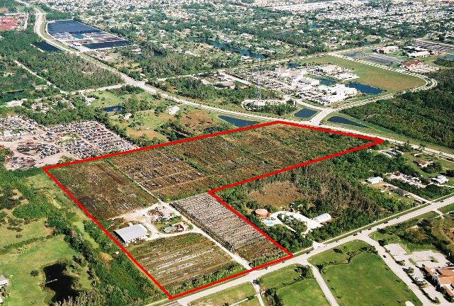
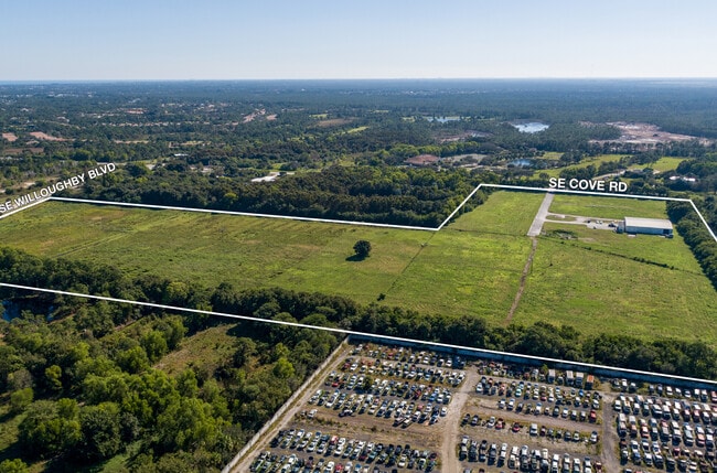
2005 Se Cove Rd
55-38-41-000-066-00010-7
TRACTS 1 2 3 AND 6 BLOCK 66 SAINT LUCIE INLET FARMS ACCORDING TO THE PLAT THEREOF RECORDED IN PLAT BOOK 1 PAGE 98 PUBLIC RECORDS PALM BEACH NOW MARTIN COUNTY FLORIDA LESS AND EXCEPT THOSE LANDS DESCRIBED IN OR 3005/1136 1492/2143 1492/2140 AND 947/39
Pasture
Martin
A1A
Florida
B and X Area of moderate flood hazard, usually the area between the limits of the 100-year and 500-year floods.
1
2024
35.04 AC
2025
Martin
001107
Port St Lucie/Fort Pierce
10,652 SF
Port St. Lucie, FL
NEARBY LISTINGS FOR SALE OR LEASE
DEMOGRAPHICS near 2005 Se Cove Rd
1 mile
3 mile
5 mile
2025 Total Population
2,609
40,573
87,975
2030 Population
2,678
41,972
91,067
Pop Growth 2025-2030
+ 2.64%
+ 3.45%
+ 3.51%
Average Age
48
48
49
2025 Total Households
1,045
17,304
38,944
HH Growth 2025-2030
+ 2.30%
+ 3.36%
+ 3.49%
Median Household Inc
$68,541
$71,051
$71,909
Avg Household Size
2.30
2.20
2.20
2025 Avg HH Vehicles
2.00
2.00
2.00
Median Home Value
$411,163
$396,849
$411,247
Median Year Built
1985
1988
1986
Nearby Places
Map Layers
Map Styles
 Street
 Aerial
Layers
 Traffic
 Biking
Places
Listings with unknown addresses are not visible on the map
- Restaurants
- Banks
- Shops
- Fitness
- Groceries
Nearby Properties
Address
Land Use
TOTAL SIZE
Lot Size
Zoning
Address
Land Use
TOTAL SIZE
Lot Size
Zoning
309,276 SF
13.73 AC
CPUD
Address
Land Use
TOTAL SIZE
Lot Size
Zoning
232,042 SF
30.99 AC
PUDR
Address
Land Use
TOTAL SIZE
Lot Size
Zoning
13.62 AC
R2
Address
Land Use
TOTAL SIZE
Lot Size
Zoning
118,989 SF
12.43 AC
PUDC
Address
Land Use
TOTAL SIZE
Lot Size
Zoning
15.79 AC
Address
Land Use
TOTAL SIZE
Lot Size
Zoning
200,686 SF
9.98 AC
RPUD
Address
Land Use
TOTAL SIZE
Lot Size
Zoning
85,872 SF
7.91 AC
CPUD
Address
Land Use
TOTAL SIZE
Lot Size
Zoning
126,304 SF
36 AC
R2
Address
Land Use
TOTAL SIZE
Lot Size
Zoning
334,117 SF
54 AC
RPUD
Address
Land Use
TOTAL SIZE
Lot Size
Zoning
307,010 SF
33.70 AC
CPUD
Address
Land Use
TOTAL SIZE
Lot Size
Zoning
182,982 SF
28.90 AC
PUDR
Address
Land Use
TOTAL SIZE
Lot Size
Zoning
45,029 SF
11.80 AC
PUDC
Address
Land Use
TOTAL SIZE
Lot Size
Zoning
136,749 SF
14.90 AC
GC
Address
Land Use
TOTAL SIZE
Lot Size
Zoning
212,454 SF
33.77 AC
CPUD
Address
Land Use
TOTAL SIZE
Lot Size
Zoning
136,615 SF
21.72 AC
Address
Land Use
TOTAL SIZE
Lot Size
Zoning
48,450 SF
7.94 AC
Address
Land Use
TOTAL SIZE
Lot Size
Zoning
30,423 SF
13.74 AC
WGC
Address
Land Use
TOTAL SIZE
Lot Size
Zoning
59,023 SF
12.31 AC
Address
Land Use
TOTAL SIZE
Lot Size
Zoning
106,105 SF
7.41 AC
PUDR
Address
Land Use
TOTAL SIZE
Lot Size
Zoning
102,843 SF
9.03 AC
Address
Land Use
TOTAL SIZE
Lot Size
Zoning
39,801 SF
8.50 AC
LI
Address
Land Use
TOTAL SIZE
Lot Size
Zoning
153,260 SF
13.50 AC
PS
Address
Land Use
TOTAL SIZE
Lot Size
Zoning
105,716 SF
10.13 AC
R5
Address
Land Use
TOTAL SIZE
Lot Size
Zoning
56,281 SF
28.86 AC
LI
Address
Land Use
TOTAL SIZE
Lot Size
Zoning
192,772 SF
18.80 AC
M1
Address
Land Use
TOTAL SIZE
Lot Size
Zoning
50,773 SF
9.40 AC
COR2
Address
Land Use
TOTAL SIZE
Lot Size
Zoning
69,133 SF
6 AC
PUDC
Address
Land Use
TOTAL SIZE
Lot Size
Zoning
100,318 SF
14.98 AC
CPUD
Address
Land Use
TOTAL SIZE
Lot Size
Zoning
131,383 SF
8.80 AC
R3A
Address
Land Use
TOTAL SIZE
Lot Size
Zoning
63,133 SF
19.65 AC
A1
The World's #1 Commercial Real Estate Marketplace
Connect with us
© 2026 CoStar Group
The information above has been obtained from sources believed reliable. While we do not doubt its accuracy we have not verified it and make no guarantee, warranty or representation about it. It is your responsibility to independently confirm its accuracy and completeness. Any projections, opinions, assumptions, or estimates used are for example only and do not represent the current or future performance of the property. The value of this transaction to you depends on tax and other factors which should be evaluated by your tax, financial, and legal advisors. You and your advisors should conduct a careful, independent investigation of the property to determine to your satisfaction the suitability of the property for your needs.