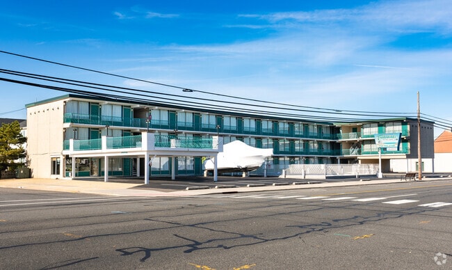
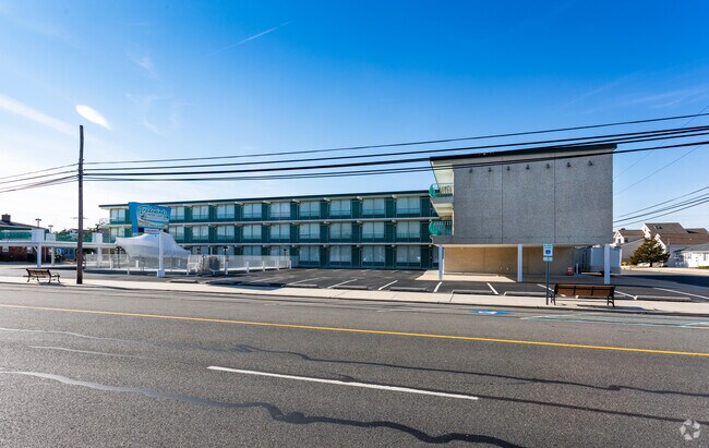
Property Record
2006 Gr Central Ave, Lavallette, NJ 08735
NEARBY LISTINGS FOR SALE OR LEASE
Property Detail
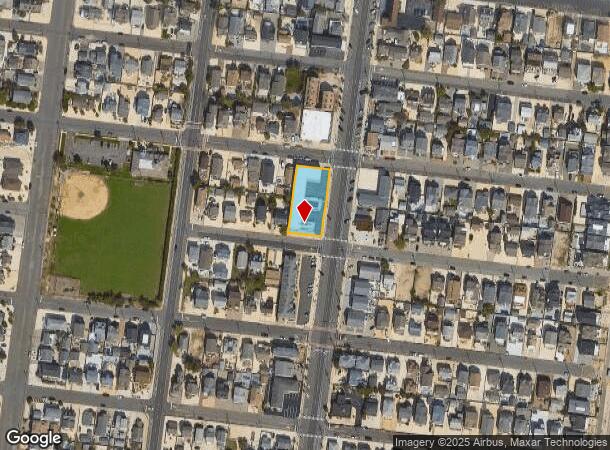
2006 Gr Central Ave
Lakewood-New Brunswick, NJ
Lavallette By The Sea
16-00047-01-00004
200X100 1,2,3
Commercialnec
Ocean
AE
New Jersey
34029C0329F
4
2024
0.46 AC
2025
North Shore
722500
Northern New Jersey
18,680 SF
DEMOGRAPHICS near 2006 Gr Central Ave
1 Mile
3 Mile
5 Mile
2024 Total Population
8,003
27,576
76,052
2029 Population
9,486
32,248
84,730
Pop Growth 2024-2029
+ 18.53%
+ 16.94%
+ 11.41%
Average Age
53
51
45
2024 Total Households
3,960
13,511
32,169
HH Growth 2024-2029
+ 18.28%
+ 17.06%
+ 11.97%
Median Household Inc
$96,909
$70,766
$85,174
Avg Household Size
1.90
2.00
2.30
2024 Avg HH Vehicles
2.00
2.00
2.00
Median Home Value
$682,930
$616,551
$438,576
Median Year Built
1982
1971
1973
Nearby Places
Map Layers
Map Styles
 Street
 Aerial
- Restaurants
- Banks
- Shops
- Fitness
- Groceries
PUBLIC TRANSPORTATION
COMMUTER RAIL
Bay Head (North Jersey Coast Line - NJ Transit Commuter Rail (NJ Transit))
DRIVE
WALK
Distance
Bay Head (North Jersey Coast Line - NJ Transit Commuter Rail (NJ Transit))
17 min
8.1 mi
Point Pleasant Beach (North Jersey Coast Line - NJ Transit Commuter Rail (NJ Transit))
DRIVE
WALK
Distance
Point Pleasant Beach (North Jersey Coast Line - NJ Transit Commuter Rail (NJ Transit))
19 min
9.4 mi
Freight Ports
New York Container Terminal
DRIVE
WALK
Distance
New York Container Terminal
82 min
58.8 mi
Nearby Properties
Address
Land Use
TOTAL SIZE
Lot Size
Zoning
Address
Land Use
TOTAL SIZE
Lot Size
Zoning
1.27 AC
P
Address
Land Use
TOTAL SIZE
Lot Size
Zoning
744 SF
0.69 AC
RB
Address
Land Use
TOTAL SIZE
Lot Size
Zoning
44,768 SF
0.62 AC
RRA
Address
Land Use
TOTAL SIZE
Lot Size
Zoning
Address
Land Use
TOTAL SIZE
Lot Size
Zoning
2.67 AC
SMF
Address
Land Use
TOTAL SIZE
Lot Size
Zoning
2,636 SF
2.90 AC
RRA
Address
Land Use
TOTAL SIZE
Lot Size
Zoning
12,520 SF
1.81 AC
RB
Address
Land Use
TOTAL SIZE
Lot Size
Zoning
39,331 SF
0.52 AC
RR
Address
Land Use
TOTAL SIZE
Lot Size
Zoning
4,563 SF
2.50 AC
RR
Address
Land Use
TOTAL SIZE
Lot Size
Zoning
1.19 AC
RB
Address
Land Use
TOTAL SIZE
Lot Size
Zoning
0.97 AC
RB
Address
Land Use
TOTAL SIZE
Lot Size
Zoning
12.70 AC
PUB
Address
Land Use
TOTAL SIZE
Lot Size
Zoning
0.82 AC
RB
Address
Land Use
TOTAL SIZE
Lot Size
Zoning
1.37 AC
RRS
Address
Land Use
TOTAL SIZE
Lot Size
Zoning
6.16 AC
MF16
Address
Land Use
TOTAL SIZE
Lot Size
Zoning
1.30 AC
RR
Address
Land Use
TOTAL SIZE
Lot Size
Zoning
0.75 AC
RR
Address
Land Use
TOTAL SIZE
Lot Size
Zoning
20,271 SF
0.96 AC
PUB
Address
Land Use
TOTAL SIZE
Lot Size
Zoning
3,209 SF
7.40 AC
GB
Address
Land Use
TOTAL SIZE
Lot Size
Zoning
1.36 AC
PUB
Address
Land Use
TOTAL SIZE
Lot Size
Zoning
8.78 AC
P
Address
Land Use
TOTAL SIZE
Lot Size
Zoning
Address
Land Use
TOTAL SIZE
Lot Size
Zoning
2.50 AC
RR
Address
Land Use
TOTAL SIZE
Lot Size
Zoning
1,344 SF
0.20 AC
RR
Address
Land Use
TOTAL SIZE
Lot Size
Zoning
8.19 AC
P
Address
Land Use
TOTAL SIZE
Lot Size
Zoning
12,008 SF
0.53 AC
RB
Address
Land Use
TOTAL SIZE
Lot Size
Zoning
29,422 SF
1.30 AC
Address
Land Use
TOTAL SIZE
Lot Size
Zoning
1.29 AC
Address
Land Use
TOTAL SIZE
Lot Size
Zoning
2.04 AC
LDR
Address
Land Use
TOTAL SIZE
Lot Size
Zoning
12.01 AC
P
The World's #1 Commercial Real Estate Marketplace
Connect with us
© 2026 CoStar Group
The information above has been obtained from sources believed reliable. While we do not doubt its accuracy we have not verified it and make no guarantee, warranty or representation about it. It is your responsibility to independently confirm its accuracy and completeness. Any projections, opinions, assumptions, or estimates used are for example only and do not represent the current or future performance of the property. The value of this transaction to you depends on tax and other factors which should be evaluated by your tax, financial, and legal advisors. You and your advisors should conduct a careful, independent investigation of the property to determine to your satisfaction the suitability of the property for your needs.