Property Record
2006 Highway 218 W, Indian Trail, NC 28079


NEARBY LISTINGS FOR SALE OR LEASE
-
-
View all Indian Trail listings for sale on LoopNet.com
Property Detail
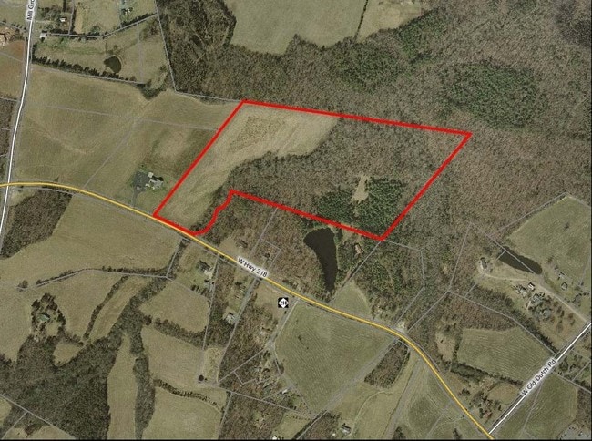
2006 Highway 218 W
08-282-019-D
#1 - #3 OPCP359
Agriculturalland
Union
AE
North Carolina
3710553100J
35.12 AC
2025
Union County
2025
Charlotte
020203
Charlotte-Concord-Gastonia, NC-SC
DEMOGRAPHICS near 2006 Highway 218 W
1 Mile
3 Mile
5 Mile
2024 Total Population
339
7,398
31,957
2029 Population
381
8,102
35,128
Pop Growth 2024-2029
+ 12.39%
+ 9.52%
+ 9.92%
Average Age
44
43
41
2024 Total Households
125
2,709
11,271
HH Growth 2024-2029
+ 12.00%
+ 9.67%
+ 9.94%
Median Household Inc
$71,249
$97,563
$102,353
Avg Household Size
2.70
2.70
2.80
2024 Avg HH Vehicles
2.00
3.00
2.00
Median Home Value
$375,757
$382,392
$364,876
Median Year Built
1990
1994
1996
Nearby Places
Map Layers
Map Styles
 Street
 Aerial
- Restaurants
- Banks
- Shops
- Fitness
- Groceries
PUBLIC TRANSPORTATION
AIRPORT
Concord-Padgett Regional
DRIVE
WALK
Distance
Concord-Padgett Regional
28 min
21.5 mi
Charlotte/Douglas International
DRIVE
WALK
Distance
Charlotte/Douglas International
43 min
24.9 mi
Freight Ports
North Charleston Terminal
DRIVE
WALK
Distance
North Charleston Terminal
241 min
198.6 mi
Nearby Properties
Address
Land Use
TOTAL SIZE
Lot Size
Zoning
Address
Land Use
TOTAL SIZE
Lot Size
Zoning
44,941 SF
66.62 AC
RA-40 FAIR
Address
Land Use
TOTAL SIZE
Lot Size
Zoning
83,934 SF
49.40 AC
RA-40 FAIR
Address
Land Use
TOTAL SIZE
Lot Size
Zoning
9,762 SF
134.77 AC
R-15 STALL
Address
Land Use
TOTAL SIZE
Lot Size
Zoning
21,001 SF
20.22 AC
R
Address
Land Use
TOTAL SIZE
Lot Size
Zoning
313.72 AC
RA-40 FAIR
Address
Land Use
TOTAL SIZE
Lot Size
Zoning
10,491 SF
14.38 AC
RA-40 FAIR
Address
Land Use
TOTAL SIZE
Lot Size
Zoning
15,192 SF
9.82 AC
RA-40 FAIR
Address
Land Use
TOTAL SIZE
Lot Size
Zoning
4,500 SF
133.78 AC
RA-40 FAIR
Address
Land Use
TOTAL SIZE
Lot Size
Zoning
21,916 SF
3 AC
R
Address
Land Use
TOTAL SIZE
Lot Size
Zoning
17.23 AC
R-20 UNION
Address
Land Use
TOTAL SIZE
Lot Size
Zoning
10,159 SF
5.17 AC
R
Address
Land Use
TOTAL SIZE
Lot Size
Zoning
53.40 AC
RA-40 FAIR
Address
Land Use
TOTAL SIZE
Lot Size
Zoning
17,943 SF
7.63 AC
RA-40 FAIR
Address
Land Use
TOTAL SIZE
Lot Size
Zoning
111.37 AC
RA-40 FAIR
Address
Land Use
TOTAL SIZE
Lot Size
Zoning
8.81 AC
RA-40 UNIO
Address
Land Use
TOTAL SIZE
Lot Size
Zoning
16,000 SF
20 AC
B-4 FAIRVI
Address
Land Use
TOTAL SIZE
Lot Size
Zoning
46.22 AC
RA-40 UNIO
Address
Land Use
TOTAL SIZE
Lot Size
Zoning
3.97 AC
RA-40 FAIR
Address
Land Use
TOTAL SIZE
Lot Size
Zoning
9.31 AC
RA-40 FAIR
Address
Land Use
TOTAL SIZE
Lot Size
Zoning
75.87 AC
RA-40 UNIO
Address
Land Use
TOTAL SIZE
Lot Size
Zoning
3.19 AC
RA-20 UNIO
Address
Land Use
TOTAL SIZE
Lot Size
Zoning
8.18 AC
RA-40 FAIR
Address
Land Use
TOTAL SIZE
Lot Size
Zoning
3.07 AC
RA-40 FAIR
Address
Land Use
TOTAL SIZE
Lot Size
Zoning
4.49 AC
RA-40 FAIR
Address
Land Use
TOTAL SIZE
Lot Size
Zoning
7.65 AC
RA-40 FAIR
Address
Land Use
TOTAL SIZE
Lot Size
Zoning
21,600 SF
10.85 AC
LI FAIRVIE
Address
Land Use
TOTAL SIZE
Lot Size
Zoning
3.36 AC
RA-40 UNIO
Address
Land Use
TOTAL SIZE
Lot Size
Zoning
17.63 AC
RA-40 FAIR
Address
Land Use
TOTAL SIZE
Lot Size
Zoning
150.10 AC
RA-40 UNIO
Address
Land Use
TOTAL SIZE
Lot Size
Zoning
4.03 AC
RA-40 FAIR
The World's #1 Commercial Real Estate Marketplace
Connect with us
© 2026 CoStar Group
The information above has been obtained from sources believed reliable. While we do not doubt its accuracy we have not verified it and make no guarantee, warranty or representation about it. It is your responsibility to independently confirm its accuracy and completeness. Any projections, opinions, assumptions, or estimates used are for example only and do not represent the current or future performance of the property. The value of this transaction to you depends on tax and other factors which should be evaluated by your tax, financial, and legal advisors. You and your advisors should conduct a careful, independent investigation of the property to determine to your satisfaction the suitability of the property for your needs.